Halifax Topo Map Virginia
To zoom in, hover over the map of Halifax
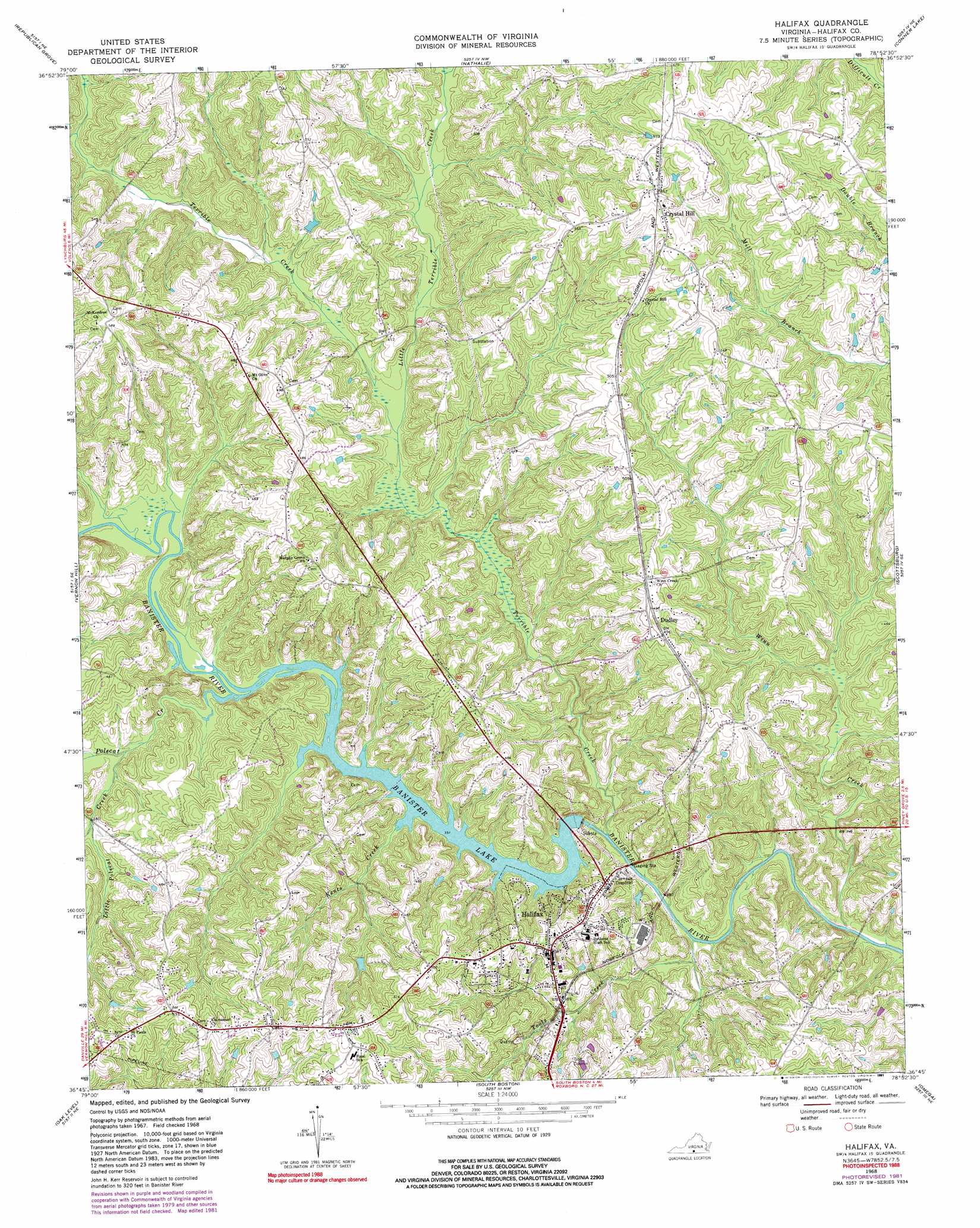
USGS Topo Quad 36078g8 - 1:24,000 scale
| Topo Map Name: | Halifax |
| USGS Topo Quad ID: | 36078g8 |
| Print Size: | ca. 21 1/4" wide x 27" high |
| Southeast Coordinates: | 36.75° N latitude / 78.875° W longitude |
| Map Center Coordinates: | 36.8125° N latitude / 78.9375° W longitude |
| U.S. State: | VA |
| Filename: | o36078g8.jpg |
| Download Map JPG Image: | Halifax topo map 1:24,000 scale |
| Map Type: | Topographic |
| Topo Series: | 7.5´ |
| Map Scale: | 1:24,000 |
| Source of Map Images: | United States Geological Survey (USGS) |
| Alternate Map Versions: |
Halifax VA 1968, updated 1972 Download PDF Buy paper map Halifax VA 1968, updated 1981 Download PDF Buy paper map Halifax VA 1968, updated 1991 Download PDF Buy paper map Halifax VA 2010 Download PDF Buy paper map Halifax VA 2013 Download PDF Buy paper map Halifax VA 2016 Download PDF Buy paper map |
1:24,000 Topo Quads surrounding Halifax
Straightstone |
Long Island |
Brookneal |
Aspen |
Charlotte Court House |
Mount Airy |
Republican Grove |
Nathalie |
Conner Lake |
Saxe |
Java |
Vernon Hill |
Halifax |
Scottsburg |
Clover |
Ingram |
Oak Level |
South Boston |
Omega |
Buffalo Springs |
Milton |
Alton |
Cluster Springs |
Virgilina |
Nelson |
> Back to 36078e1 at 1:100,000 scale
> Back to 36078a1 at 1:250,000 scale
> Back to U.S. Topo Maps home
Halifax topo map: Gazetteer
Halifax: Dams
Banister Dam elevation 111m 364′Halifax: Parks
Mountain Road Historic District elevation 144m 472′Halifax: Populated Places
Banister Town elevation 124m 406′Canterbury Estates elevation 117m 383′
Crystal Hill elevation 171m 561′
Dudley elevation 152m 498′
Halifax elevation 141m 462′
McKendree elevation 181m 593′
Mountain Road elevation 162m 531′
Riverview Heights elevation 114m 374′
Youngers Store elevation 152m 498′
Halifax: Reservoirs
Banister Lake elevation 111m 364′Halifax: Streams
Kents Creek elevation 119m 390′Little Polecat Creek elevation 123m 403′
Little Terrible Creek elevation 111m 364′
Polecat Creek elevation 125m 410′
Terrible Creek elevation 105m 344′
Toots Creek elevation 100m 328′
Winn Creek elevation 113m 370′
Halifax digital topo map on disk
Buy this Halifax topo map showing relief, roads, GPS coordinates and other geographical features, as a high-resolution digital map file on DVD:
Western Virginia & Southern West Virginia
Buy digital topo maps: Western Virginia & Southern West Virginia