Sonora Topo Map Arkansas
To zoom in, hover over the map of Sonora
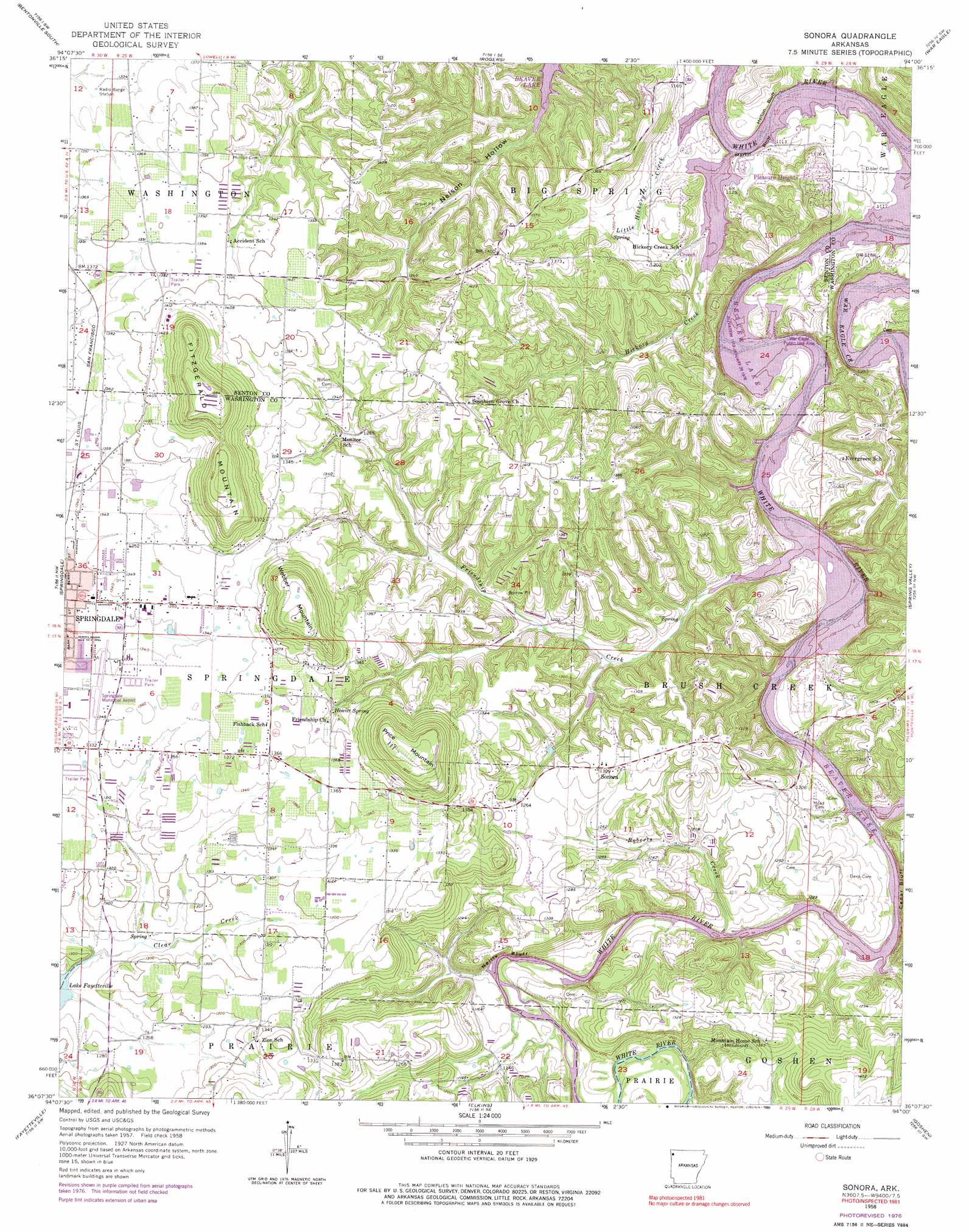
USGS Topo Quad 36094b1 - 1:24,000 scale
| Topo Map Name: | Sonora |
| USGS Topo Quad ID: | 36094b1 |
| Print Size: | ca. 21 1/4" wide x 27" high |
| Southeast Coordinates: | 36.125° N latitude / 94° W longitude |
| Map Center Coordinates: | 36.1875° N latitude / 94.0625° W longitude |
| U.S. State: | AR |
| Filename: | o36094b1.jpg |
| Download Map JPG Image: | Sonora topo map 1:24,000 scale |
| Map Type: | Topographic |
| Topo Series: | 7.5´ |
| Map Scale: | 1:24,000 |
| Source of Map Images: | United States Geological Survey (USGS) |
| Alternate Map Versions: |
Sonora AR 1958, updated 1959 Download PDF Buy paper map Sonora AR 1958, updated 1965 Download PDF Buy paper map Sonora AR 1958, updated 1977 Download PDF Buy paper map Sonora AR 1958, updated 1990 Download PDF Buy paper map Sonora AR 1994, updated 1998 Download PDF Buy paper map Sonora AR 2011 Download PDF Buy paper map Sonora AR 2014 Download PDF Buy paper map |
1:24,000 Topo Quads surrounding Sonora
Hiwasse |
Bentonville North |
Pea Ridge |
Garfield |
Beaver |
Centerton |
Bentonville South |
Rogers |
War Eagle |
Sandstone Mountain |
Robinson |
Springdale |
Sonora |
Spring Valley |
Hindsville |
Wheeler |
Fayettville |
Elkins |
Goshen |
Hartwell |
Prairie Grove |
West Fork |
Sulphur City |
Durham |
Japton |
> Back to 36094a1 at 1:100,000 scale
> Back to 36094a1 at 1:250,000 scale
> Back to U.S. Topo Maps home
Sonora topo map: Gazetteer
Sonora: Airports
Circle S Farms Airport elevation 361m 1184′Springdale Municipal Airport elevation 411m 1348′
Sonora: Cliffs
Cedar Bluff elevation 342m 1122′Helton Bluff elevation 348m 1141′
Martin Bluff elevation 344m 1128′
Neills Bluff elevation 376m 1233′
Sonora: Crossings
Bland Ferry (historical) elevation 342m 1122′Gibson Ford (historical) elevation 342m 1122′
Head Ford (historical) elevation 342m 1122′
Helton Ford (historical) elevation 344m 1128′
Neills Bluff Ford (historical) elevation 342m 1122′
Sonora: Dams
Tenenbaum Lake Dam elevation 370m 1213′Sonora: Parks
Blue Springs Use Area elevation 351m 1151′Bobby Hopper Park elevation 413m 1354′
Lake Fayetteville Park elevation 381m 1250′
War Eagle Public Use Area elevation 347m 1138′
Sonora: Populated Places
Accident elevation 420m 1377′Beau-O-Rama elevation 381m 1250′
Blue Springs Village elevation 356m 1167′
Creech elevation 357m 1171′
Pleasure Heights elevation 382m 1253′
Rochelle Riviera elevation 381m 1250′
Sonora elevation 399m 1309′
Sonora: Reservoirs
Tenenbaum Lake elevation 370m 1213′Sonora: Springs
Blue Springs elevation 354m 1161′Hewitt Spring elevation 400m 1312′
Sonora: Streams
Friendship Creek elevation 342m 1122′Hickory Creek elevation 342m 1122′
Little Hickory Creek elevation 345m 1131′
Roberts Creek elevation 343m 1125′
Sonora: Summits
Fitzgerald Mountain elevation 497m 1630′Harp Mountain elevation 435m 1427′
Price Mountain elevation 492m 1614′
Webber Mountain elevation 477m 1564′
Sonora: Valleys
Mill Hollow elevation 343m 1125′Sonora digital topo map on disk
Buy this Sonora topo map showing relief, roads, GPS coordinates and other geographical features, as a high-resolution digital map file on DVD: