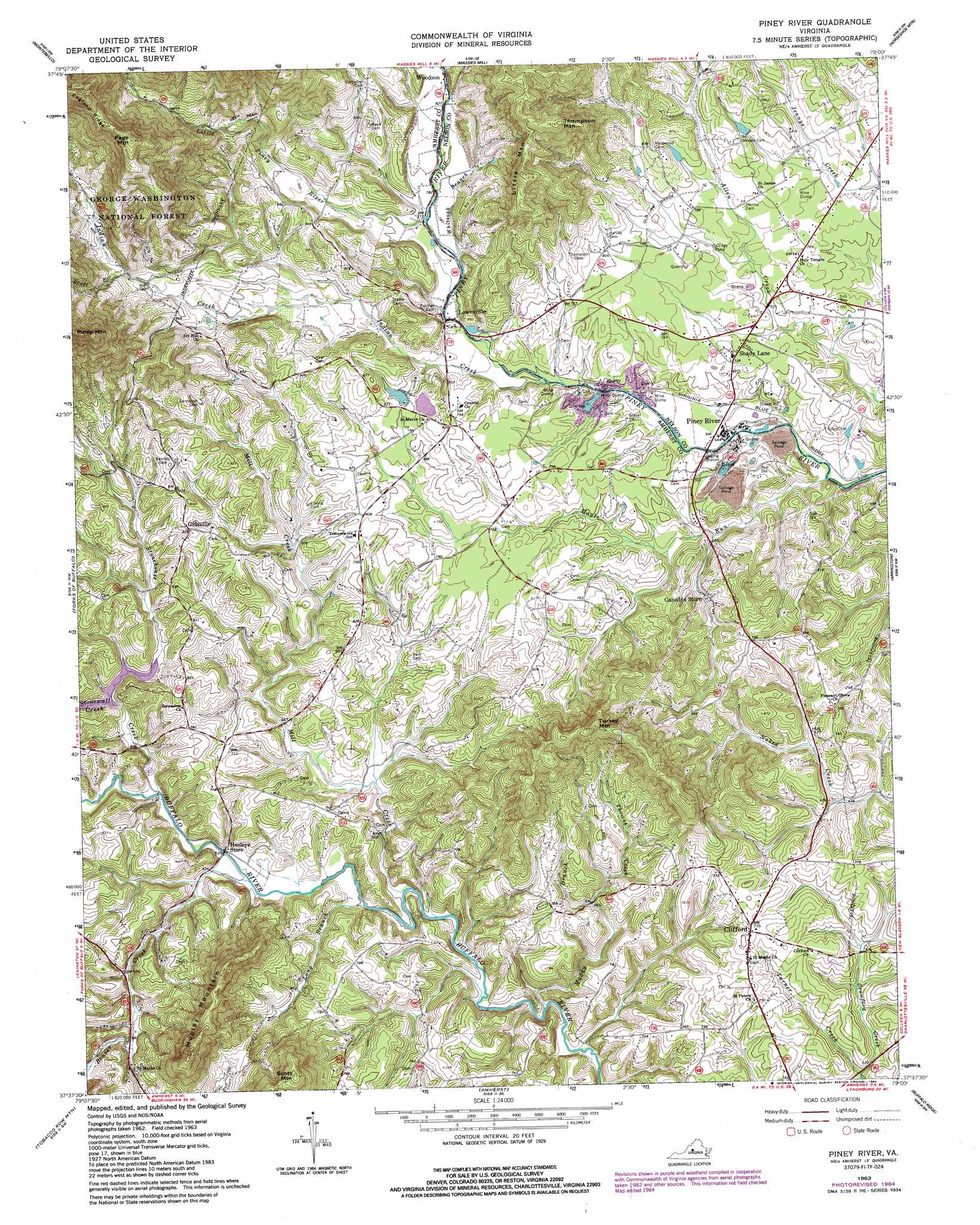
Piney River Topo Map Virginia
To zoom in, hover over the map of Piney River
USGS Topo Quad 37079f1 - 1:24,000 scale
| Topo Map Name: | Piney River |
| USGS Topo Quad ID: | 37079f1 |
| Print Size: | ca. 21 1/4" wide x 27" high |
| Southeast Coordinates: | 37.625° N latitude / 79° W longitude |
| Map Center Coordinates: | 37.6875° N latitude / 79.0625° W longitude |
| U.S. State: | VA |
| Filename: | o37079f1.jpg |
| Download Map JPG Image: | Piney River topo map 1:24,000 scale |
| Map Type: | Topographic |
| Topo Series: | 7.5´ |
| Map Scale: | 1:24,000 |
| Source of Map Images: | United States Geological Survey (USGS) |
| Alternate Map Versions: |
Piney River VA 1963, updated 1965 Download PDF Buy paper map Piney River VA 1963, updated 1984 Download PDF Buy paper map Piney River VA 2011 Download PDF Buy paper map Piney River VA 2013 Download PDF Buy paper map Piney River VA 2016 Download PDF Buy paper map |
| FStopo: | US Forest Service topo Piney River is available: Download FStopo PDF Download FStopo TIF |
1:24,000 Topo Quads surrounding Piney River
Brownsburg |
Vesuvius |
Big Levels |
Sherando |
Greenfield |
Cornwall |
Montebello |
Massies Mill |
Horseshoe Mountain |
Lovingston |
Buena Vista |
Forks Of Buffalo |
Piney River |
Arrington |
Shipman |
Big Island |
Tobacco Row Mountain |
Amherst |
Buffalo Ridge |
Gladstone |
Boonsboro |
Lynchburg |
Kelly |
Stonewall |
Vera |
> Back to 37079e1 at 1:100,000 scale
> Back to 37078a1 at 1:250,000 scale
> Back to U.S. Topo Maps home
Piney River topo map: Gazetteer
Piney River: Dams
Buffalo River Dam Number Three elevation 210m 688′Winton Country Club Dam elevation 207m 679′
Piney River: Populated Places
Clifford elevation 237m 777′Gidsville elevation 261m 856′
Lowesville elevation 224m 734′
Piney River elevation 194m 636′
Shady Lane elevation 224m 734′
Piney River: Ridges
England Ridge elevation 643m 2109′Piney River: Streams
Beaver Creek elevation 189m 620′Crawford Creek elevation 188m 616′
Indian Creek elevation 213m 698′
Little Piney River elevation 233m 764′
Long Branch elevation 181m 593′
Maple Run elevation 186m 610′
Mill Creek elevation 178m 583′
Muddy Branch elevation 175m 574′
Scott Branch elevation 317m 1040′
Stonehouse Creek elevation 192m 629′
Stonewall Creek elevation 221m 725′
Thomas Creek elevation 204m 669′
Whiteoak Branch elevation 230m 754′
Piney River: Summits
Little Mountain elevation 395m 1295′Mobley Mountain elevation 383m 1256′
Page Mountain elevation 603m 1978′
Scott Mountain elevation 401m 1315′
Thompson Mountain elevation 428m 1404′
Turkey Mountain elevation 384m 1259′
Piney River digital topo map on disk
Buy this Piney River topo map showing relief, roads, GPS coordinates and other geographical features, as a high-resolution digital map file on DVD:
Western Virginia & Southern West Virginia
Buy digital topo maps: Western Virginia & Southern West Virginia