Lynchburg Topo Map Virginia
To zoom in, hover over the map of Lynchburg
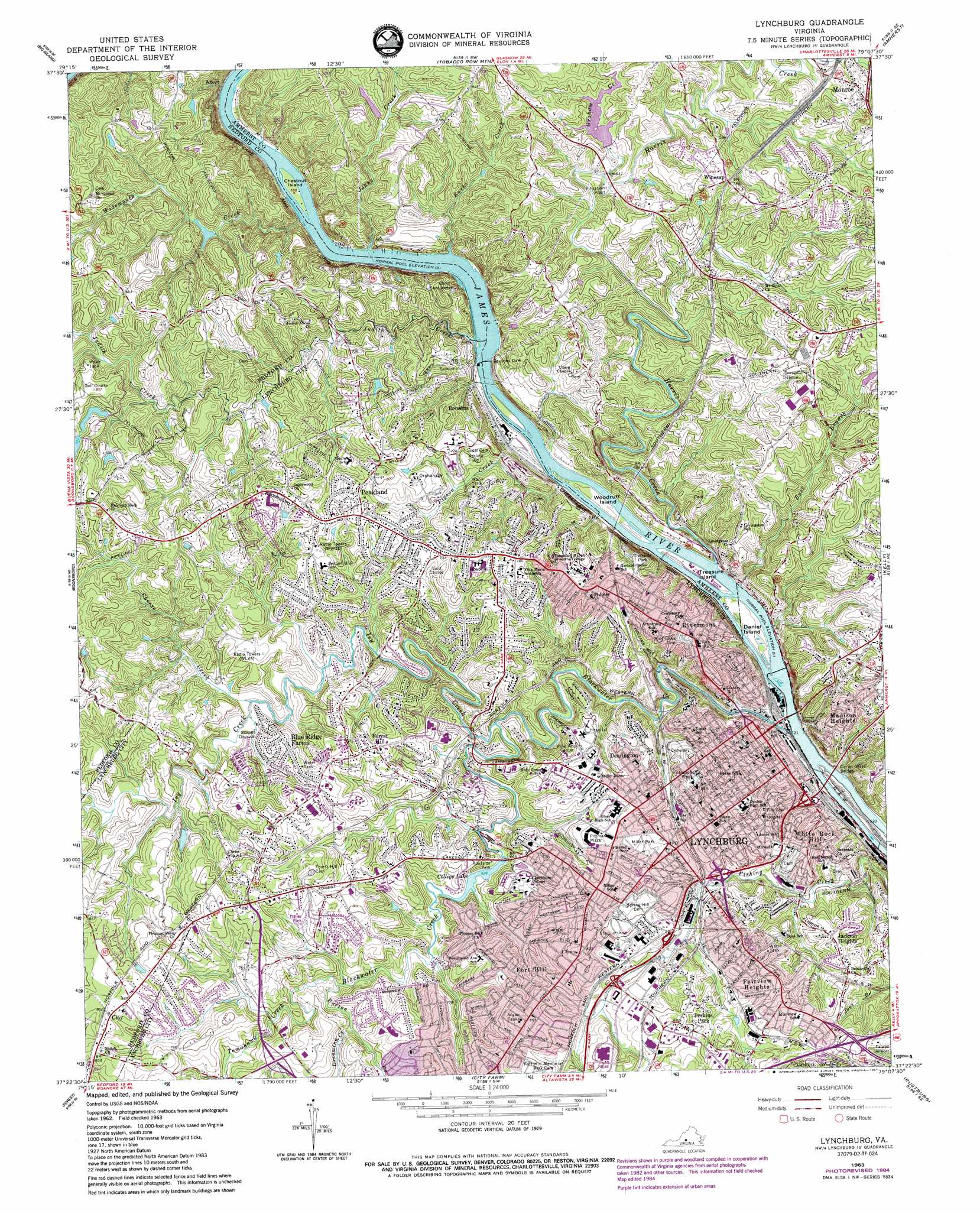
USGS Topo Quad 37079d2 - 1:24,000 scale
| Topo Map Name: | Lynchburg |
| USGS Topo Quad ID: | 37079d2 |
| Print Size: | ca. 21 1/4" wide x 27" high |
| Southeast Coordinates: | 37.375° N latitude / 79.125° W longitude |
| Map Center Coordinates: | 37.4375° N latitude / 79.1875° W longitude |
| U.S. State: | VA |
| Filename: | o37079d2.jpg |
| Download Map JPG Image: | Lynchburg topo map 1:24,000 scale |
| Map Type: | Topographic |
| Topo Series: | 7.5´ |
| Map Scale: | 1:24,000 |
| Source of Map Images: | United States Geological Survey (USGS) |
| Alternate Map Versions: |
Lynchburg VA 1963, updated 1965 Download PDF Buy paper map Lynchburg VA 1963, updated 1969 Download PDF Buy paper map Lynchburg VA 1963, updated 1978 Download PDF Buy paper map Lynchburg VA 1963, updated 1984 Download PDF Buy paper map Lynchburg VA 1963, updated 1987 Download PDF Buy paper map Lynchburg VA 1977, updated 1983 Download PDF Buy paper map Lynchburg VA 2011 Download PDF Buy paper map Lynchburg VA 2013 Download PDF Buy paper map Lynchburg VA 2016 Download PDF Buy paper map |
1:24,000 Topo Quads surrounding Lynchburg
Glasgow |
Buena Vista |
Forks Of Buffalo |
Piney River |
Arrington |
Snowden |
Big Island |
Tobacco Row Mountain |
Amherst |
Buffalo Ridge |
Sedalia |
Boonsboro |
Lynchburg |
Kelly |
Stonewall |
Goode |
Forest |
City Farm |
Rustburg |
Concord |
Huddleston |
Lynch Station |
Castle Craig |
Gladys |
Mike |
> Back to 37079a1 at 1:100,000 scale
> Back to 37078a1 at 1:250,000 scale
> Back to U.S. Topo Maps home
Lynchburg topo map: Gazetteer
Lynchburg: Airports
L G Hospital Heliport elevation 214m 702′Virginia Baptist Hospital Heliport elevation 230m 754′
Lynchburg: Bridges
Carter Glass Bridge elevation 148m 485′Rivermont Bridge elevation 162m 531′
Sixth Street Bridge elevation 157m 515′
Lynchburg: Dams
College Lake Dam elevation 198m 649′Elon Water Works Dam elevation 202m 662′
Harrington Dam elevation 196m 643′
Horners Dam elevation 238m 780′
Lassiters Dam elevation 241m 790′
Reusens Dam elevation 167m 547′
Reusens Dam elevation 167m 547′
Scots Mill Dam elevation 156m 511′
Lynchburg: Islands
Chestnut Island elevation 168m 551′Daniel Island elevation 158m 518′
Percivals Island elevation 160m 524′
Treasure Island elevation 158m 518′
Woodruff Island elevation 158m 518′
Lynchburg: Parks
Blackwater Creek Natural Area elevation 195m 639′Blackwater Park elevation 188m 616′
College Hill Recreation Center elevation 216m 708′
College Park elevation 218m 715′
Daniels Hill Historic District elevation 208m 682′
Daniels Hill Recreation Center elevation 206m 675′
Diamond Hill Historic District elevation 210m 688′
Diamond Hill Recreation Center elevation 227m 744′
Fairview Heights Recreation Center elevation 256m 839′
Federal Hill Historic District elevation 210m 688′
Fisher Recreation Center elevation 237m 777′
Fox Field elevation 209m 685′
Friendship Circle elevation 239m 784′
Garland Hill Historic District elevation 234m 767′
Guggenheimer Memorial Park elevation 221m 725′
Jackson Heights Park elevation 228m 748′
Jackson Heights Recreation Center elevation 236m 774′
Jefferson Park elevation 209m 685′
Jefferson Park Recreation Center elevation 210m 688′
John Warwick Daniel Statue elevation 243m 797′
Lower Basin Historic District elevation 179m 587′
Lynchburg Stadium elevation 246m 807′
Miller Park elevation 226m 741′
Peaks View Park elevation 210m 688′
Perrymont Park elevation 232m 761′
Point of Honor Monument elevation 182m 597′
Reservoir Park elevation 230m 754′
Riverside Park elevation 229m 751′
Sandusky Park elevation 195m 639′
Shellenberger Field elevation 229m 751′
Yoder Recreation Center elevation 205m 672′
Younger Park elevation 232m 761′
Lynchburg: Pillars
Lynchburg Boulder elevation 153m 501′Lynchburg: Populated Places
Abert elevation 172m 564′Black Rock Farm elevation 244m 800′
Blue Ridge Farms elevation 227m 744′
Bluemont Estates elevation 241m 790′
Brandywine elevation 225m 738′
Clay elevation 262m 859′
College Hill elevation 235m 770′
Court House Hill elevation 206m 675′
Daniels Hill elevation 208m 682′
Dearington elevation 227m 744′
Diamond Hill elevation 216m 708′
Fairview Heights elevation 250m 820′
Federal Hill elevation 210m 688′
Forest Brook Hills elevation 233m 764′
Forest Hill elevation 238m 780′
Fort Hill elevation 245m 803′
Garland Hill elevation 215m 705′
Ivanhoe Forest elevation 252m 826′
Jackson Heights elevation 229m 751′
Keystone Forest elevation 224m 734′
Lavino Village elevation 205m 672′
Long Meadows elevation 236m 774′
Lynchburg elevation 192m 629′
Maple Hill elevation 219m 718′
Mayfield elevation 241m 790′
Meadowview Hills elevation 243m 797′
Merry Moor elevation 234m 767′
Panorama Hills elevation 227m 744′
Peakland elevation 243m 797′
Perkins Park elevation 249m 816′
Reusens elevation 210m 688′
Rivermont elevation 230m 754′
Ruritan elevation 257m 843′
Three Fountains elevation 224m 734′
West Briar elevation 246m 807′
West Lynchburg elevation 226m 741′
Westbrook elevation 238m 780′
Westview elevation 254m 833′
White Rock Hill elevation 227m 744′
Winesap elevation 233m 764′
Woodbine Village elevation 217m 711′
Lynchburg: Post Offices
Lynchburg Post Office elevation 197m 646′Madison Heights Post Office elevation 226m 741′
Miller Park Station Lynchburg Post Office elevation 231m 757′
Rivermont Station Lynchburg Post Office elevation 227m 744′
Lynchburg: Reservoirs
Clay Street Reservoir elevation 220m 721′College Hill Reservoir elevation 245m 803′
College Lake elevation 198m 649′
Elon Water Works Reservoir elevation 202m 662′
Reusens Reservoir elevation 167m 547′
Lynchburg: Streams
Blackwater Creek elevation 151m 495′Buck Branch elevation 159m 521′
Burks Creek elevation 169m 554′
Burton Creek elevation 194m 636′
Cheese Creek elevation 171m 561′
Dreaming Creek elevation 200m 656′
Graham Creek elevation 189m 620′
Harris Creek elevation 156m 511′
Ivy Creek elevation 173m 567′
Johns Creek elevation 168m 551′
Judith Creek elevation 168m 551′
Muddy Creek elevation 198m 649′
Pigeon Creek elevation 156m 511′
Tomahawk Creek elevation 195m 639′
Widemouth Creek elevation 168m 551′
Lynchburg: Summits
Lookout Point elevation 231m 757′Lynchburg: Tunnels
Jefferson Street Tunnel elevation 164m 538′Lynchburg digital topo map on disk
Buy this Lynchburg topo map showing relief, roads, GPS coordinates and other geographical features, as a high-resolution digital map file on DVD:
Western Virginia & Southern West Virginia
Buy digital topo maps: Western Virginia & Southern West Virginia