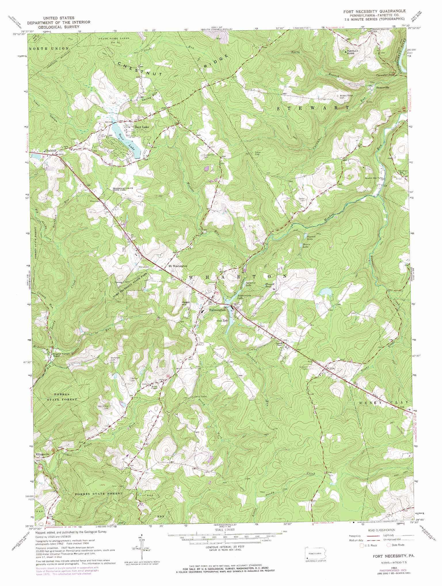
Fort Necessity Topo Map Pennsylvania
To zoom in, hover over the map of Fort Necessity
USGS Topo Quad 39079g5 - 1:24,000 scale
| Topo Map Name: | Fort Necessity |
| USGS Topo Quad ID: | 39079g5 |
| Print Size: | ca. 21 1/4" wide x 27" high |
| Southeast Coordinates: | 39.75° N latitude / 79.5° W longitude |
| Map Center Coordinates: | 39.8125° N latitude / 79.5625° W longitude |
| U.S. State: | PA |
| Filename: | o39079g5.jpg |
| Download Map JPG Image: | Fort Necessity topo map 1:24,000 scale |
| Map Type: | Topographic |
| Topo Series: | 7.5´ |
| Map Scale: | 1:24,000 |
| Source of Map Images: | United States Geological Survey (USGS) |
| Alternate Map Versions: |
Fort Necessity PA 1964, updated 1965 Download PDF Buy paper map Fort Necessity PA 1964, updated 1973 Download PDF Buy paper map Fort Necessity PA 2010 Download PDF Buy paper map Fort Necessity PA 2013 Download PDF Buy paper map Fort Necessity PA 2016 Download PDF Buy paper map |
1:24,000 Topo Quads surrounding Fort Necessity
Fayette City |
Saint Clairsville |
Connellsville |
Donegal |
Seven Springs |
New Salem |
Uniontown |
South Connellsville |
Mill Run |
Kingwood |
Smithfield |
Brownfield |
Fort Necessity |
Ohiopyle |
Confluence |
Lake Lynn |
Bruceton Mills |
Brandonville |
Friendsville |
Accident |
Masontown |
Valley Point |
Cuzzart |
Sang Run |
Mchenry |
> Back to 39079e1 at 1:100,000 scale
> Back to 39078a1 at 1:250,000 scale
> Back to U.S. Topo Maps home
Fort Necessity topo map: Gazetteer
Fort Necessity: Airports
Hager Airstrip elevation 548m 1797′Nemacolin Airport elevation 614m 2014′
Fort Necessity: Dams
Deer Lake Dam elevation 588m 1929′Heritage Reservation Dam elevation 622m 2040′
Lake George Dam elevation 524m 1719′
Oak Lake Dam elevation 528m 1732′
Fort Necessity: Falls
Cucumber Falls elevation 374m 1227′Fort Necessity: Lakes
Surprise Lake elevation 523m 1715′Fort Necessity: Parks
Braddock Grave State Park elevation 584m 1916′Fort Necessity National Battlefield elevation 596m 1955′
Fort Necessity State Park elevation 568m 1863′
Fort Necessity: Populated Places
Chalkhill elevation 631m 2070′Deer Lake elevation 602m 1975′
Farmington elevation 560m 1837′
Fayette Springs elevation 581m 1906′
Mount Washington elevation 558m 1830′
Stonerville elevation 403m 1322′
Fort Necessity: Reservoirs
Alanconnie Lake elevation 523m 1715′Bluegill Pond elevation 591m 1938′
Deer Lake elevation 585m 1919′
Heritage Lake elevation 622m 2040′
Lake George elevation 524m 1719′
Oak Lake elevation 528m 1732′
Peters Lake elevation 537m 1761′
Russell Lake elevation 518m 1699′
Fort Necessity: Streams
Beaver Creek elevation 464m 1522′Braddock Run elevation 501m 1643′
Chaney Run elevation 491m 1610′
Cucumber Run elevation 348m 1141′
Deadman Run elevation 517m 1696′
Great Meadow Run elevation 529m 1735′
McIntire Run elevation 484m 1587′
Noahs Glade elevation 555m 1820′
North Branch Cucumber Run elevation 397m 1302′
Scotts Run elevation 486m 1594′
Smiley Run elevation 593m 1945′
Stony Fork elevation 477m 1564′
Fort Necessity: Summits
Hager Hill elevation 630m 2066′Kentuck Knob elevation 622m 2040′
Fort Necessity: Trails
Great Gorge Trail elevation 376m 1233′Fort Necessity: Valleys
Trout Hollow elevation 590m 1935′Fort Necessity digital topo map on disk
Buy this Fort Necessity topo map showing relief, roads, GPS coordinates and other geographical features, as a high-resolution digital map file on DVD:
 map DVD")