Hundred Topo Map West Virginia
To zoom in, hover over the map of Hundred
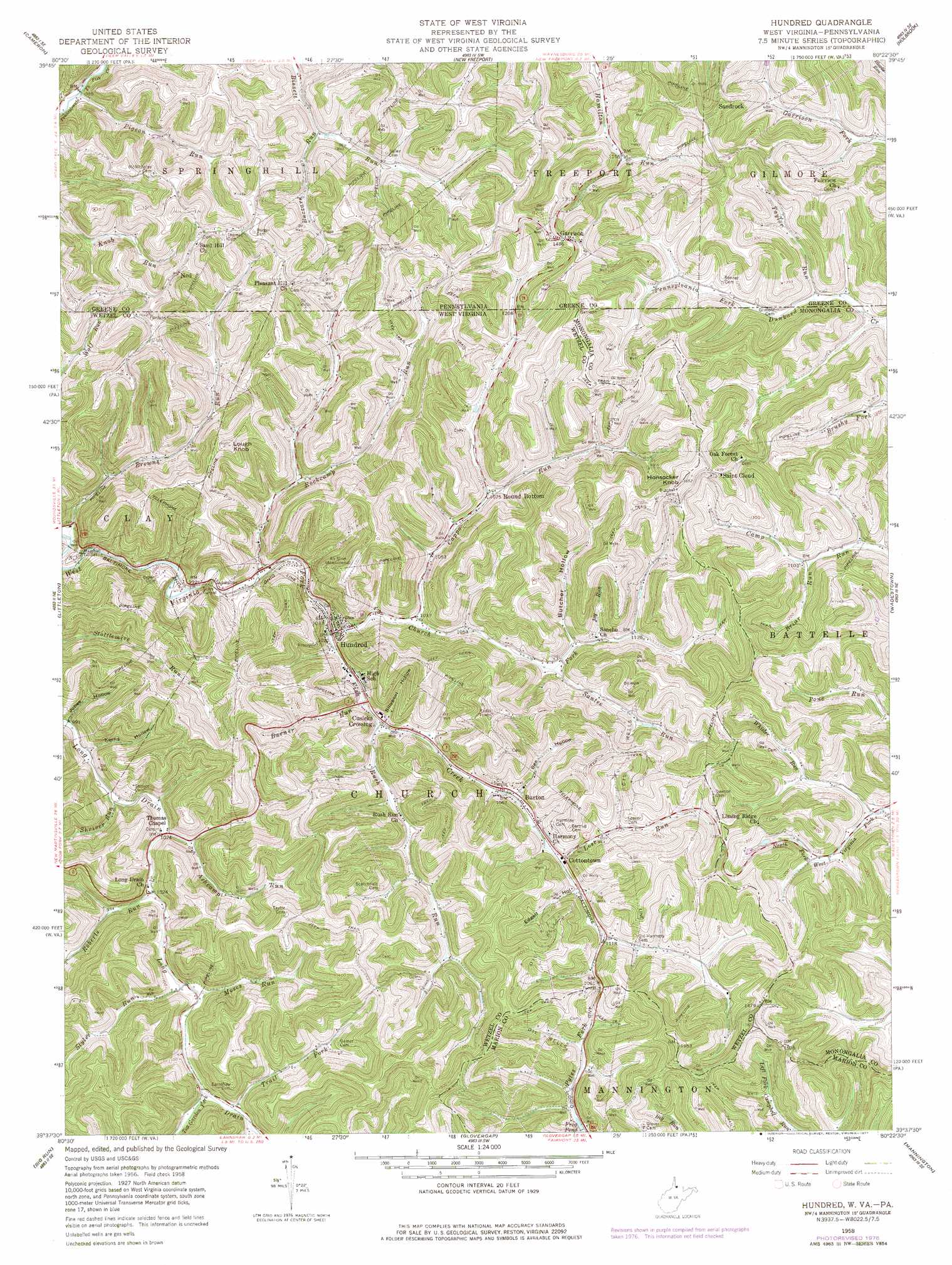
USGS Topo Quad 39080f4 - 1:24,000 scale
| Topo Map Name: | Hundred |
| USGS Topo Quad ID: | 39080f4 |
| Print Size: | ca. 21 1/4" wide x 27" high |
| Southeast Coordinates: | 39.625° N latitude / 80.375° W longitude |
| Map Center Coordinates: | 39.6875° N latitude / 80.4375° W longitude |
| U.S. States: | WV, PA |
| Filename: | o39080f4.jpg |
| Download Map JPG Image: | Hundred topo map 1:24,000 scale |
| Map Type: | Topographic |
| Topo Series: | 7.5´ |
| Map Scale: | 1:24,000 |
| Source of Map Images: | United States Geological Survey (USGS) |
| Alternate Map Versions: |
Hundred WV 1958, updated 1960 Download PDF Buy paper map Hundred WV 1958, updated 1972 Download PDF Buy paper map Hundred WV 1958, updated 1977 Download PDF Buy paper map Hundred WV 1998, updated 2000 Download PDF Buy paper map Hundred WV 2011 Download PDF Buy paper map Hundred WV 2014 Download PDF Buy paper map Hundred WV 2016 Download PDF Buy paper map |
1:24,000 Topo Quads surrounding Hundred
Moundsville |
Majorsville |
Wind Ridge |
Rogersville |
Waynesburg |
Glen Easton |
Cameron |
New Freeport |
Holbrook |
Oak Forest |
Wileyville |
Littleton |
Hundred |
Wadestown |
Blacksville |
Pine Grove |
Big Run |
Glover Gap |
Mannington |
Grant Town |
Center Point |
Folsom |
Wallace |
Shinnston |
Fairmont West |
> Back to 39080e1 at 1:100,000 scale
> Back to 39080a1 at 1:250,000 scale
> Back to U.S. Topo Maps home
Hundred topo map: Gazetteer
Hundred: Bridges
Fish Creek Covered Bridge elevation 314m 1030′Hundred: Populated Places
Burton elevation 327m 1072′Cottontown elevation 330m 1082′
Cusicks Crossing elevation 317m 1040′
Garrison elevation 459m 1505′
Hundred elevation 313m 1026′
Ned elevation 456m 1496′
Round Bottom elevation 330m 1082′
Saint Cloud elevation 456m 1496′
Sandrock elevation 468m 1535′
Hundred: Reservoirs
Frog Pond elevation 331m 1085′Hundred: Streams
Ashcamp Run elevation 308m 1010′Briar Run elevation 334m 1095′
Browns Run elevation 288m 944′
Browns Run elevation 288m 944′
Burner Run elevation 314m 1030′
Butcher Fork elevation 329m 1079′
Buzzard Run elevation 326m 1069′
Cappo Run elevation 317m 1040′
Church Fork elevation 310m 1017′
Joy Run elevation 334m 1095′
Lost Run elevation 329m 1079′
Moses Run elevation 313m 1026′
Pigeon Run elevation 299m 980′
Roberts Run elevation 309m 1013′
Rockcamp Run elevation 303m 994′
Rockcamp Run elevation 305m 1000′
Rush Run elevation 315m 1033′
Santee Run elevation 326m 1069′
Shriver Run elevation 306m 1003′
Styles Run elevation 312m 1023′
Taylor Run elevation 327m 1072′
Tea Garden Fork elevation 318m 1043′
Trail Fork elevation 327m 1072′
Whisler Run elevation 325m 1066′
Hundred: Summits
Honsocker Knob elevation 493m 1617′Lough Knob elevation 484m 1587′
Hundred: Tunnels
Marshall Tunnel elevation 310m 1017′Soles Tunnel elevation 310m 1017′
Hundred: Valleys
Bee Hollow elevation 328m 1076′Billygoat Hollow elevation 320m 1049′
Butcher Hollow elevation 333m 1092′
Edgell Hollow elevation 335m 1099′
Jobes Hollow elevation 302m 990′
Kerns Hollow elevation 304m 997′
Hundred digital topo map on disk
Buy this Hundred topo map showing relief, roads, GPS coordinates and other geographical features, as a high-resolution digital map file on DVD:
 map DVD")