Vail Pass Topo Map Colorado
To zoom in, hover over the map of Vail Pass
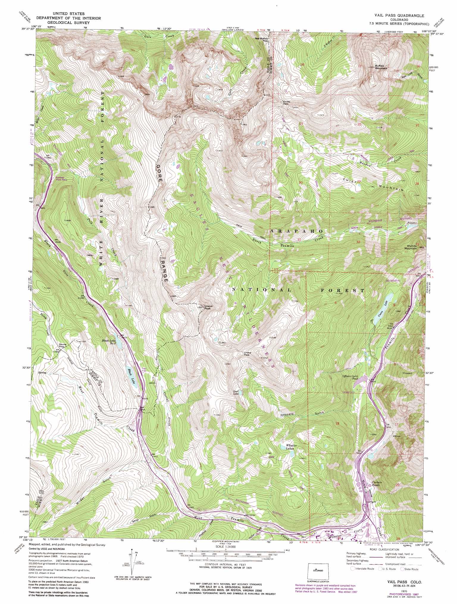
USGS Topo Quad 39106e2 - 1:24,000 scale
| Topo Map Name: | Vail Pass |
| USGS Topo Quad ID: | 39106e2 |
| Print Size: | ca. 21 1/4" wide x 27" high |
| Southeast Coordinates: | 39.5° N latitude / 106.125° W longitude |
| Map Center Coordinates: | 39.5625° N latitude / 106.1875° W longitude |
| U.S. State: | CO |
| Filename: | o39106e2.jpg |
| Download Map JPG Image: | Vail Pass topo map 1:24,000 scale |
| Map Type: | Topographic |
| Topo Series: | 7.5´ |
| Map Scale: | 1:24,000 |
| Source of Map Images: | United States Geological Survey (USGS) |
| Alternate Map Versions: |
Vail Pass CO 1970, updated 1973 Download PDF Buy paper map Vail Pass CO 1970, updated 1973 Download PDF Buy paper map Vail Pass CO 1970, updated 1980 Download PDF Buy paper map Vail Pass CO 1970, updated 1988 Download PDF Buy paper map Vail Pass CO 2011 Download PDF Buy paper map Vail Pass CO 2013 Download PDF Buy paper map Vail Pass CO 2016 Download PDF Buy paper map |
| FStopo: | US Forest Service topo Vail Pass is available: Download FStopo PDF Download FStopo TIF |
1:24,000 Topo Quads surrounding Vail Pass
Piney Peak |
Mount Powell |
Squaw Creek |
Ute Peak |
Byers Peak |
Vail West |
Vail East |
Willow Lakes |
Dillon |
Loveland Pass |
Minturn |
Red Cliff |
Vail Pass |
Frisco |
Keystone |
Mount Of The Holy Cross |
Pando |
Copper Mountain |
Breckenridge |
Boreas Pass |
Homestake Reservoir |
Leadville North |
Climax |
Alma |
Como |
> Back to 39106e1 at 1:100,000 scale
> Back to 39106a1 at 1:250,000 scale
> Back to U.S. Topo Maps home
Vail Pass topo map: Gazetteer
Vail Pass: Dams
Black Lake Number 1 Dam elevation 3240m 10629′Black Lake Number 2 Dam elevation 3164m 10380′
Vail Pass: Flats
Wheeler Flats elevation 2964m 9724′Vail Pass: Gaps
Eccles Pass elevation 3625m 11893′Red Buffalo Pass elevation 3577m 11735′
Shrine Pass elevation 3379m 11085′
Uneva Pass elevation 3634m 11922′
Vail Pass elevation 3236m 10616′
Vail Pass: Lakes
Curtain Ponds elevation 2948m 9671′Lost Lake elevation 3535m 11597′
Officers Gulch Pond elevation 2881m 9452′
Wheeler Lakes elevation 3377m 11079′
Vail Pass: Mines
Eagle Number One Mine elevation 3361m 11026′Vail Pass Mine elevation 3213m 10541′
Vail Pass: Populated Places
Copper Mountain elevation 2955m 9694′Wheeler Junction elevation 2956m 9698′
Vail Pass: Reservoirs
Black Lake elevation 3204m 10511′Black Lake Number 1 Reservoir elevation 3240m 10629′
Black Lake Number 2 elevation 3164m 10380′
Uneva Lake elevation 2931m 9616′
Vail Pass: Streams
Corral Creek elevation 3132m 10275′Guller Creek elevation 3035m 9957′
Polk Creek elevation 2887m 9471′
Stafford Creek elevation 3073m 10082′
West Tenmile Creek elevation 2952m 9685′
Vail Pass: Summits
Buffalo Mountain elevation 3886m 12749′Chief Mountain elevation 3466m 11371′
Uneva Peak elevation 3819m 12529′
Wichita Mountain elevation 3307m 10849′
Vail Pass: Trails
Wheeler Dillion Trail elevation 3424m 11233′Vail Pass: Valleys
Officers Gulch elevation 2889m 9478′Smith Gulch elevation 3122m 10242′
Wilder Gulch elevation 3161m 10370′
Vail Pass digital topo map on disk
Buy this Vail Pass topo map showing relief, roads, GPS coordinates and other geographical features, as a high-resolution digital map file on DVD: