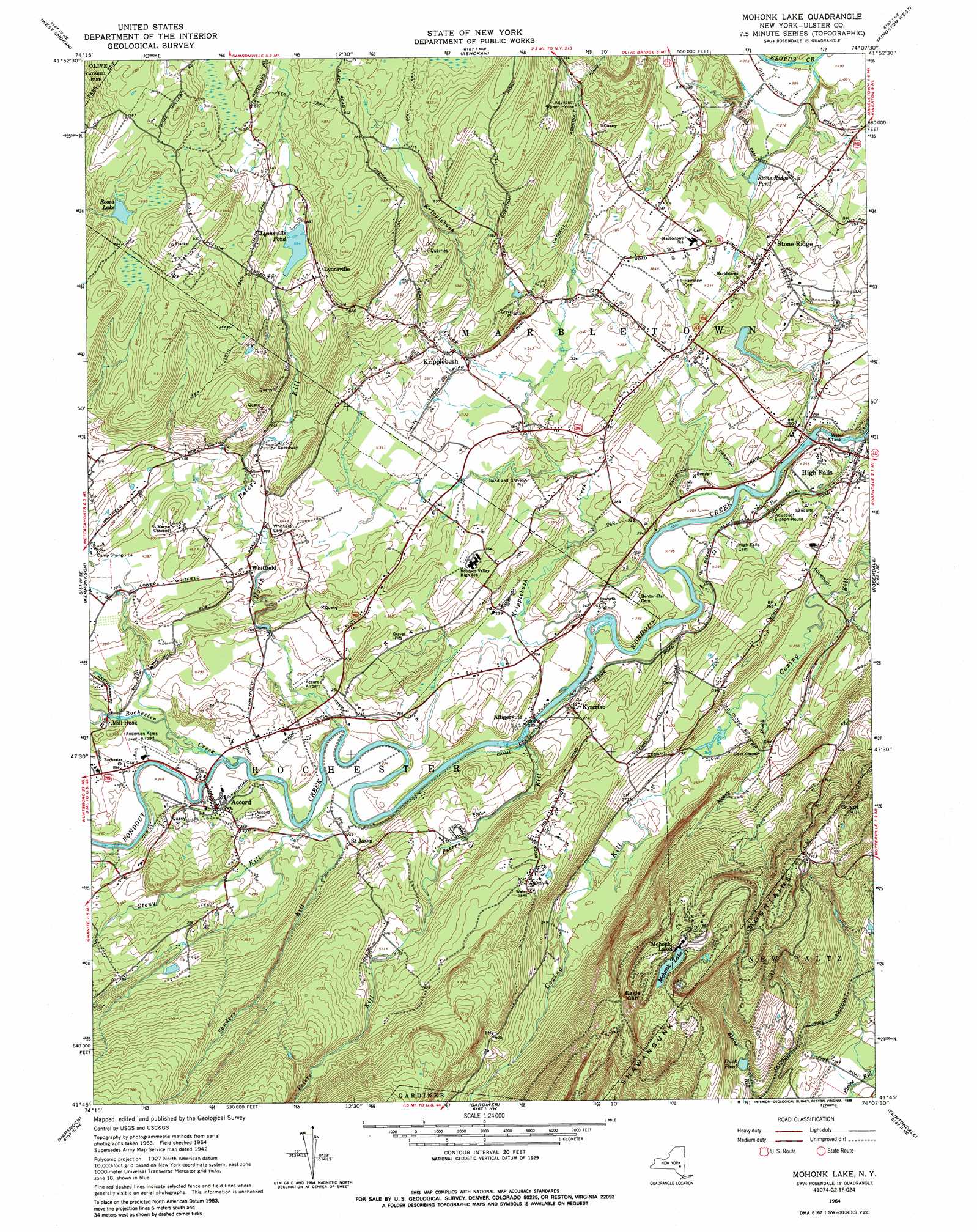
Mohonk Lake Topo Map New York
To zoom in, hover over the map of Mohonk Lake
USGS Topo Quad 41074g2 - 1:24,000 scale
| Topo Map Name: | Mohonk Lake |
| USGS Topo Quad ID: | 41074g2 |
| Print Size: | ca. 21 1/4" wide x 27" high |
| Southeast Coordinates: | 41.75° N latitude / 74.125° W longitude |
| Map Center Coordinates: | 41.8125° N latitude / 74.1875° W longitude |
| U.S. State: | NY |
| Filename: | o41074g2.jpg |
| Download Map JPG Image: | Mohonk Lake topo map 1:24,000 scale |
| Map Type: | Topographic |
| Topo Series: | 7.5´ |
| Map Scale: | 1:24,000 |
| Source of Map Images: | United States Geological Survey (USGS) |
| Alternate Map Versions: |
Mohonk Lake NY 1942, updated 1959 Download PDF Buy paper map Mohonk Lake NY 1964, updated 1966 Download PDF Buy paper map Mohonk Lake NY 1964, updated 1988 Download PDF Buy paper map Mohonk Lake NY 1964, updated 1988 Download PDF Buy paper map Mohonk Lake NY 2010 Download PDF Buy paper map Mohonk Lake NY 2013 Download PDF Buy paper map Mohonk Lake NY 2016 Download PDF Buy paper map |
1:24,000 Topo Quads surrounding Mohonk Lake
Shandaken |
Phoenicia |
Bearsville |
Woodstock |
Saugerties |
Peekamoose Mountain |
West Shokan |
Ashokan |
Kingston West |
Kingston East |
Rondout Reservoir |
Kerhonkson |
Mohonk Lake |
Rosendale |
Hyde Park |
Ellenville |
Napanoch |
Gardiner |
Clintondale |
Poughkeepsie |
Wurtsboro |
Pine Bush |
Walden |
Newburgh |
Wappingers Falls |
> Back to 41074e1 at 1:100,000 scale
> Back to 41074a1 at 1:250,000 scale
> Back to U.S. Topo Maps home
Mohonk Lake topo map: Gazetteer
Mohonk Lake: Airports
Benbyre Farm Heliport elevation 80m 262′Sheeleys Farm Airport elevation 79m 259′
Mohonk Lake: Cliffs
Eagle Cliff elevation 416m 1364′Mohonk Lake: Lakes
Duck Pond elevation 182m 597′Mohonk Lake elevation 382m 1253′
Roosa Lake elevation 261m 856′
Mohonk Lake: Populated Places
Accord elevation 77m 252′Alligerville elevation 67m 219′
High Falls elevation 49m 160′
Kripplebush elevation 115m 377′
Kyserike elevation 67m 219′
Lyonsville elevation 217m 711′
Mill Hook elevation 84m 275′
Mohonk Lake elevation 381m 1250′
Saint Josen elevation 82m 269′
Stone Ridge elevation 111m 364′
Whitfield elevation 116m 380′
Mohonk Lake: Reservoirs
Lyonsville Pond elevation 202m 662′Stone Ridge Pond elevation 66m 216′
Mohonk Lake: Streams
Kripplebush Creek elevation 49m 160′Mill Brook elevation 79m 259′
Moosy Brook elevation 78m 255′
North Peters Kill elevation 67m 219′
Peters Kill elevation 55m 180′
Rochester Creek elevation 61m 200′
Sanders Kill elevation 67m 219′
Stony Kill elevation 66m 216′
Mohonk Lake: Summits
Guyot Hill elevation 383m 1256′Mohonk Lake digital topo map on disk
Buy this Mohonk Lake topo map showing relief, roads, GPS coordinates and other geographical features, as a high-resolution digital map file on DVD:
New York, Vermont, Connecticut & Western Massachusetts
Buy digital topo maps: New York, Vermont, Connecticut & Western Massachusetts