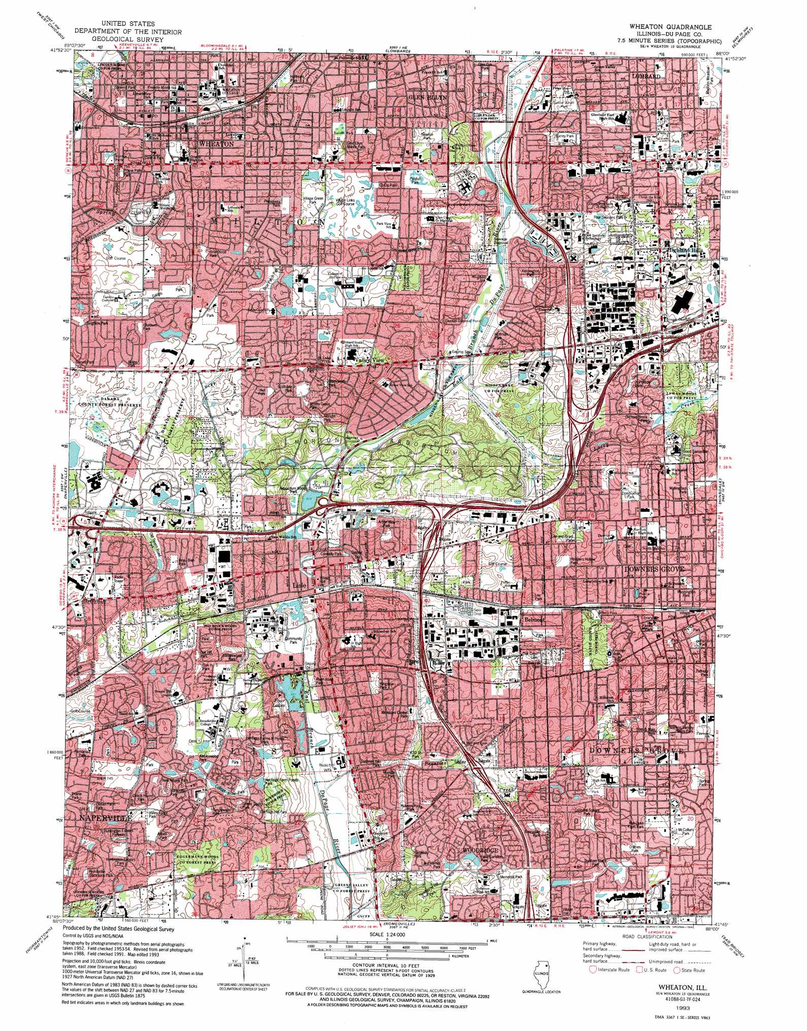
Wheaton Topo Map Illinois
To zoom in, hover over the map of Wheaton
USGS Topo Quad 41088g1 - 1:24,000 scale
| Topo Map Name: | Wheaton |
| USGS Topo Quad ID: | 41088g1 |
| Print Size: | ca. 21 1/4" wide x 27" high |
| Southeast Coordinates: | 41.75° N latitude / 88° W longitude |
| Map Center Coordinates: | 41.8125° N latitude / 88.0625° W longitude |
| U.S. State: | IL |
| Filename: | o41088g1.jpg |
| Download Map JPG Image: | Wheaton topo map 1:24,000 scale |
| Map Type: | Topographic |
| Topo Series: | 7.5´ |
| Map Scale: | 1:24,000 |
| Source of Map Images: | United States Geological Survey (USGS) |
| Alternate Map Versions: |
Wheaton IL 1954, updated 1955 Download PDF Buy paper map Wheaton IL 1962, updated 1964 Download PDF Buy paper map Wheaton IL 1962, updated 1973 Download PDF Buy paper map Wheaton IL 1962, updated 1981 Download PDF Buy paper map Wheaton IL 1962, updated 1984 Download PDF Buy paper map Wheaton IL 1993, updated 1994 Download PDF Buy paper map Wheaton IL 1998, updated 2002 Download PDF Buy paper map Wheaton IL 2012 Download PDF Buy paper map Wheaton IL 2015 Download PDF Buy paper map |
1:24,000 Topo Quads surrounding Wheaton
Elgin |
Streamwood |
Palatine |
Arlington Heights |
Park Ridge |
Geneva |
West Chicago |
Lombard |
Elmhurst |
River Forest |
Aurora North |
Naperville |
Wheaton |
Hinsdale |
Berwyn |
Aurora South |
Normantown |
Romeoville |
Sag Bridge |
Palos Park |
Yorkville Se |
Plainfield |
Joliet |
Mokena |
Tinley Park |
> Back to 41088e1 at 1:100,000 scale
> Back to 41088a1 at 1:250,000 scale
> Back to U.S. Topo Maps home
Wheaton topo map: Gazetteer
Wheaton: Airports
Corporetum Office Campus Heliport elevation 207m 679′Darien-Woodridge Fire Department Heliport elevation 235m 770′
Global Fire Protection Heliport elevation 220m 721′
Lombard Airport (historical) elevation 225m 738′
Wheaton: Forests
Maple Grove County Forest Preserve elevation 217m 711′Wheaton: Lakes
Four Lakes elevation 200m 656′Lake Marmo elevation 206m 675′
Meadow Lake elevation 204m 669′
Prince Lake elevation 216m 708′
Sterling Pond elevation 209m 685′
Wheaton: Parks
Abbeywood Park elevation 225m 738′Adams Park elevation 233m 764′
Adams Park elevation 234m 767′
Albright Park elevation 225m 738′
Appleby Park elevation 232m 761′
Arbor View Park elevation 217m 711′
Arboretum Woods Park elevation 204m 669′
Aspen Park elevation 232m 761′
Barkridge Park elevation 219m 718′
Beau Bien Park elevation 225m 738′
Belmont Prairie Nature Preserve elevation 222m 728′
Blacksmith Park elevation 233m 764′
Breckenridge Park elevation 227m 744′
Briar Knoll Park elevation 226m 741′
Briar Patch Park elevation 232m 761′
Brighton Park elevation 231m 757′
Candlewood Park elevation 223m 731′
Carriage Hill Park elevation 219m 718′
Carroll Park elevation 229m 751′
Central Park elevation 222m 728′
Chathum Park elevation 231m 757′
Clydesdale Park elevation 234m 767′
Coach House Park elevation 227m 744′
College Road Park elevation 224m 734′
Community Park elevation 203m 666′
Concord Square Park elevation 227m 744′
Connelly Park elevation 207m 679′
Co-Op Park elevation 228m 748′
Danada County Forest Preserve elevation 227m 744′
Doerhoefer Park elevation 225m 738′
Dorset Park elevation 227m 744′
Dunham Place Park elevation 231m 757′
Eggerman Woods County Forest Preserve elevation 235m 770′
Fiftyninth and Main Park elevation 234m 767′
Fisher Park elevation 219m 718′
Four Seasons Park elevation 226m 741′
Gastaldo Park elevation 223m 731′
Gilbert Park elevation 213m 698′
Glen Ellyn Manor Park elevation 232m 761′
Glen Oak County Forest Preserve elevation 210m 688′
Glen Oak Park elevation 212m 695′
Green Trails Park elevation 226m 741′
Green Valley County Forest Preserve elevation 198m 649′
Hampshire Park elevation 225m 738′
Hawthorne Hill Park elevation 217m 711′
Heritage Farm Ponds Park elevation 214m 702′
Heritage Farms N Ponds Park elevation 212m 695′
Hidden Lake County Forest Preserve elevation 214m 702′
Hitchcock Woods County Forest Preserve elevation 212m 695′
Hobson Pool Park elevation 225m 738′
Hoffman Park elevation 231m 757′
Hoffman Park elevation 207m 679′
Hoopers Hollow Park elevation 225m 738′
Hoopers Hollow Park elevation 229m 751′
Hull Park elevation 234m 767′
Huntington Estates Park elevation 226m 741′
Huntington Estates Parkway elevation 220m 721′
Kelly Park elevation 228m 748′
Kensington Park elevation 211m 692′
Kingston Park elevation 224m 734′
Lake Carleton Park elevation 222m 728′
Lake Harriet Park elevation 222m 728′
Lee and Grant Park elevation 225m 738′
Lincoln Marsh County Forest Preserve elevation 221m 725′
Lincoln Park elevation 234m 767′
Loy Park elevation 216m 708′
Lyman Woods County Forest Preserve elevation 215m 705′
Madison Meadow Park elevation 224m 734′
Mar-Duke Farm Park elevation 232m 761′
McCollum Park elevation 231m 757′
Meadows Center Park elevation 222m 728′
Memorial Park elevation 232m 761′
Memorial Park elevation 229m 751′
Memorial Park elevation 223m 731′
Methodist Park elevation 231m 757′
Milness Famey Memorial Park elevation 235m 770′
Morton Arboretum elevation 218m 715′
New Albany Park elevation 226m 741′
Newton Park elevation 236m 774′
Northside Park elevation 224m 734′
Oak Hill Park elevation 221m 725′
Oak Hill South Park elevation 223m 731′
O'Brien Park elevation 232m 761′
Old Tavern Road Park elevation 221m 725′
Olesen Farm Park elevation 221m 725′
Orchard Brook Park elevation 212m 695′
Panfish Park elevation 231m 757′
Patriots Park elevation 219m 718′
Pembroke Commons Park elevation 216m 708′
Pembroke Park elevation 230m 754′
Pennywood Park elevation 220m 721′
Prairie Garden elevation 225m 738′
Prairie Park elevation 226m 741′
Prairie Path Park elevation 224m 734′
Presidents Park elevation 231m 757′
Prince Park elevation 216m 708′
Randall Park elevation 223m 731′
Rathje Park elevation 229m 751′
Ridge Park elevation 230m 754′
River Road Park elevation 201m 659′
Scottdale Park elevation 235m 770′
Scotts Grove Park elevation 234m 767′
Seven Gables Park elevation 231m 757′
Sixtythird Street Park elevation 206m 675′
South Side Park elevation 238m 780′
Spring Hill Park elevation 215m 705′
Spring Park elevation 228m 748′
Summer Hill Park elevation 204m 669′
Sun Valley Park elevation 231m 757′
Sunnydale Park elevation 233m 764′
Sunnyside Park elevation 232m 761′
Sunset Knoll Park elevation 223m 731′
Sunset Park elevation 231m 757′
Surrey Park elevation 216m 708′
Surrey Ridge Park elevation 225m 738′
Surrey Ridge Sports Complex elevation 225m 738′
Tanglewood Park elevation 231m 757′
Tate Woods Park elevation 219m 718′
Timber Park elevation 224m 734′
Triangle Park elevation 208m 682′
Triangle Park elevation 229m 751′
Valley Forge Park elevation 222m 728′
Village Green Park elevation 234m 767′
W W Stevens Park elevation 228m 748′
Wallingford Park elevation 225m 738′
Washington Park elevation 219m 718′
Willowbrook County Forest Preserve elevation 224m 734′
Woodridge County Forest Preserve elevation 209m 685′
Wheaton: Populated Places
Arboretum Estates elevation 229m 751′Belmont elevation 211m 692′
Downers Grove elevation 226m 741′
Flowerfield elevation 212m 695′
Foxcroft elevation 232m 761′
Highland Hills elevation 227m 744′
Lisle elevation 205m 672′
Valley View elevation 231m 757′
Wheaton elevation 231m 757′
Wheaton: Post Offices
Downers Grove Post Office elevation 219m 718′Lombard Post Office elevation 228m 748′
Wheaton Post Office elevation 230m 754′
Woodridge Post Office elevation 226m 741′
Wheaton: Reservoirs
Lake Saint Benedict elevation 225m 738′Lambert Lake elevation 229m 751′
Wheaton: Streams
Lacey Creek elevation 205m 672′Prentiss Creek elevation 198m 649′
Saint Joseph Creek elevation 201m 659′
Willoway Brook elevation 204m 669′
Wheaton digital topo map on disk
Buy this Wheaton topo map showing relief, roads, GPS coordinates and other geographical features, as a high-resolution digital map file on DVD:
Northern Illinois, Northern Indiana & Southwestern Michigan
Buy digital topo maps: Northern Illinois, Northern Indiana & Southwestern Michigan