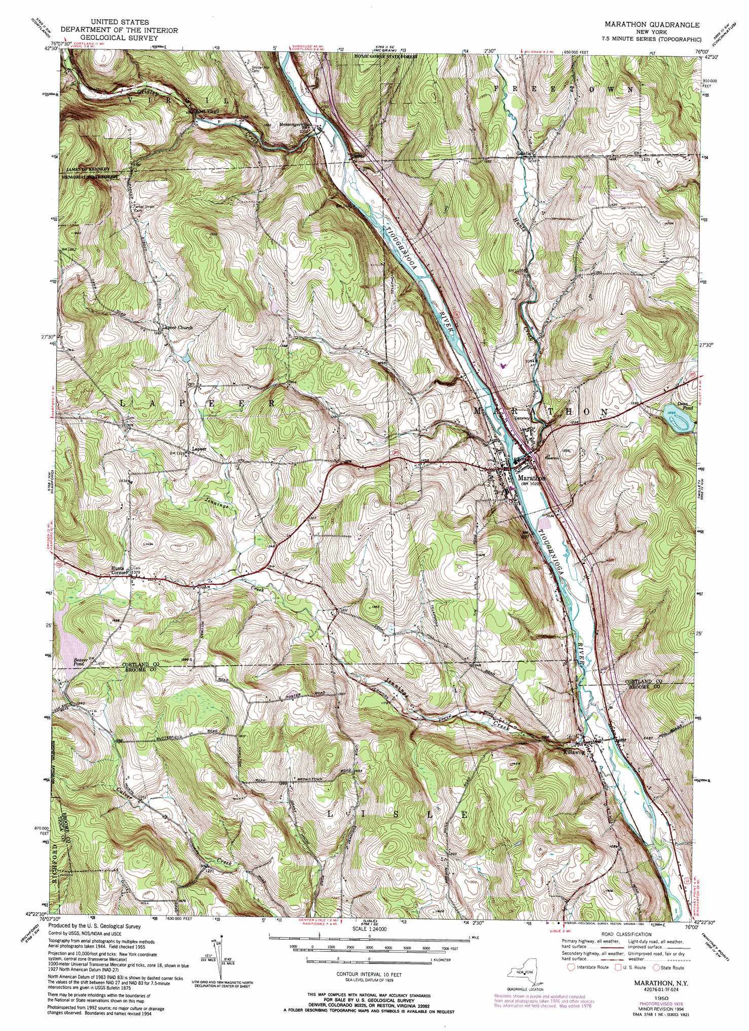
Marathon Topo Map New York
To zoom in, hover over the map of Marathon
USGS Topo Quad 42076d1 - 1:24,000 scale
| Topo Map Name: | Marathon |
| USGS Topo Quad ID: | 42076d1 |
| Print Size: | ca. 21 1/4" wide x 27" high |
| Southeast Coordinates: | 42.375° N latitude / 76° W longitude |
| Map Center Coordinates: | 42.4375° N latitude / 76.0625° W longitude |
| U.S. State: | NY |
| Filename: | o42076d1.jpg |
| Download Map JPG Image: | Marathon topo map 1:24,000 scale |
| Map Type: | Topographic |
| Topo Series: | 7.5´ |
| Map Scale: | 1:24,000 |
| Source of Map Images: | United States Geological Survey (USGS) |
| Alternate Map Versions: |
Marathon NY 1950, updated 1952 Download PDF Buy paper map Marathon NY 1950, updated 1964 Download PDF Buy paper map Marathon NY 1950, updated 1969 Download PDF Buy paper map Marathon NY 1950, updated 1979 Download PDF Buy paper map Marathon NY 1950, updated 1994 Download PDF Buy paper map Marathon NY 2010 Download PDF Buy paper map Marathon NY 2013 Download PDF Buy paper map Marathon NY 2016 Download PDF Buy paper map |
1:24,000 Topo Quads surrounding Marathon
Sempronius |
Homer |
Truxton |
Cuyler |
South Otselic |
Groton |
Cortland |
Mcgraw |
Cincinnatus |
Pitcher |
Dryden |
Harford |
Marathon |
Willet |
Smithville Flats |
Speedsville |
Richford |
Lisle |
Whitney Point |
Greene |
Candor |
Newark Valley |
Maine |
Castle Creek |
Chenango Forks |
> Back to 42076a1 at 1:100,000 scale
> Back to 42076a1 at 1:250,000 scale
> Back to U.S. Topo Maps home
Marathon topo map: Gazetteer
Marathon: Airports
Lapeer Flyer Airport elevation 390m 1279′Marathon: Lakes
Dean Pond elevation 382m 1253′Marathon: Populated Places
East Virgil elevation 360m 1181′Galatia elevation 374m 1227′
Hunts Corners elevation 421m 1381′
Killawog elevation 307m 1007′
Lapeer elevation 405m 1328′
Marathon elevation 312m 1023′
Messengerville elevation 321m 1053′
Riverside Manor elevation 320m 1049′
Marathon: Reservoirs
Beaver Pond elevation 411m 1348′Marathon: Streams
Gridley Creek elevation 321m 1053′Hunts Creek elevation 307m 1007′
Jennings Creek elevation 298m 977′
Marathon digital topo map on disk
Buy this Marathon topo map showing relief, roads, GPS coordinates and other geographical features, as a high-resolution digital map file on DVD:
New York, Vermont, Connecticut & Western Massachusetts
Buy digital topo maps: New York, Vermont, Connecticut & Western Massachusetts