Maine Topo Map New York
To zoom in, hover over the map of Maine
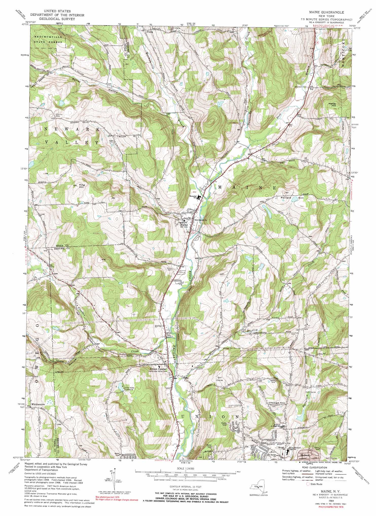
USGS Topo Quad 42076b1 - 1:24,000 scale
| Topo Map Name: | Maine |
| USGS Topo Quad ID: | 42076b1 |
| Print Size: | ca. 21 1/4" wide x 27" high |
| Southeast Coordinates: | 42.125° N latitude / 76° W longitude |
| Map Center Coordinates: | 42.1875° N latitude / 76.0625° W longitude |
| U.S. State: | NY |
| Filename: | o42076b1.jpg |
| Download Map JPG Image: | Maine topo map 1:24,000 scale |
| Map Type: | Topographic |
| Topo Series: | 7.5´ |
| Map Scale: | 1:24,000 |
| Source of Map Images: | United States Geological Survey (USGS) |
| Alternate Map Versions: |
Maine NY 1956, updated 1958 Download PDF Buy paper map Maine NY 1956, updated 1967 Download PDF Buy paper map Maine NY 1969, updated 1971 Download PDF Buy paper map Maine NY 1969, updated 1972 Download PDF Buy paper map Maine NY 1969, updated 1990 Download PDF Buy paper map Maine NY 2010 Download PDF Buy paper map Maine NY 2013 Download PDF Buy paper map Maine NY 2016 Download PDF Buy paper map |
1:24,000 Topo Quads surrounding Maine
Dryden |
Harford |
Marathon |
Willet |
Smithville Flats |
Speedsville |
Richford |
Lisle |
Whitney Point |
Greene |
Candor |
Newark Valley |
Maine |
Castle Creek |
Chenango Forks |
Owego |
Apalachin |
Endicott |
Binghamton West |
Binghamton East |
Windham |
Little Meadows |
Friendsville |
Laurel Lake |
Franklin Forks |
> Back to 42076a1 at 1:100,000 scale
> Back to 42076a1 at 1:250,000 scale
> Back to U.S. Topo Maps home
Maine topo map: Gazetteer
Maine: Forests
Ketchumville State Forest elevation 434m 1423′Maine: Populated Places
Maine elevation 278m 912′Maine Mobile Park elevation 269m 882′
Oakwoods Mobile Home Court elevation 278m 912′
Quick Mobile Home Park elevation 427m 1400′
Tiona elevation 352m 1154′
Twining Trailer Park elevation 277m 908′
Union Center elevation 273m 895′
Whittemore elevation 426m 1397′
Maine: Streams
Bradley Creek elevation 258m 846′Crocker Creek elevation 345m 1131′
East Branch Nanticoke Creek elevation 283m 928′
Ketchumville Branch elevation 272m 892′
Maine: Summits
Hardy Hill elevation 424m 1391′King Hill elevation 464m 1522′
Pollard Hill elevation 461m 1512′
Maine: Valleys
Bailey Hollow elevation 310m 1017′Cornell Hollow elevation 295m 967′
Maine digital topo map on disk
Buy this Maine topo map showing relief, roads, GPS coordinates and other geographical features, as a high-resolution digital map file on DVD:
New York, Vermont, Connecticut & Western Massachusetts
Buy digital topo maps: New York, Vermont, Connecticut & Western Massachusetts