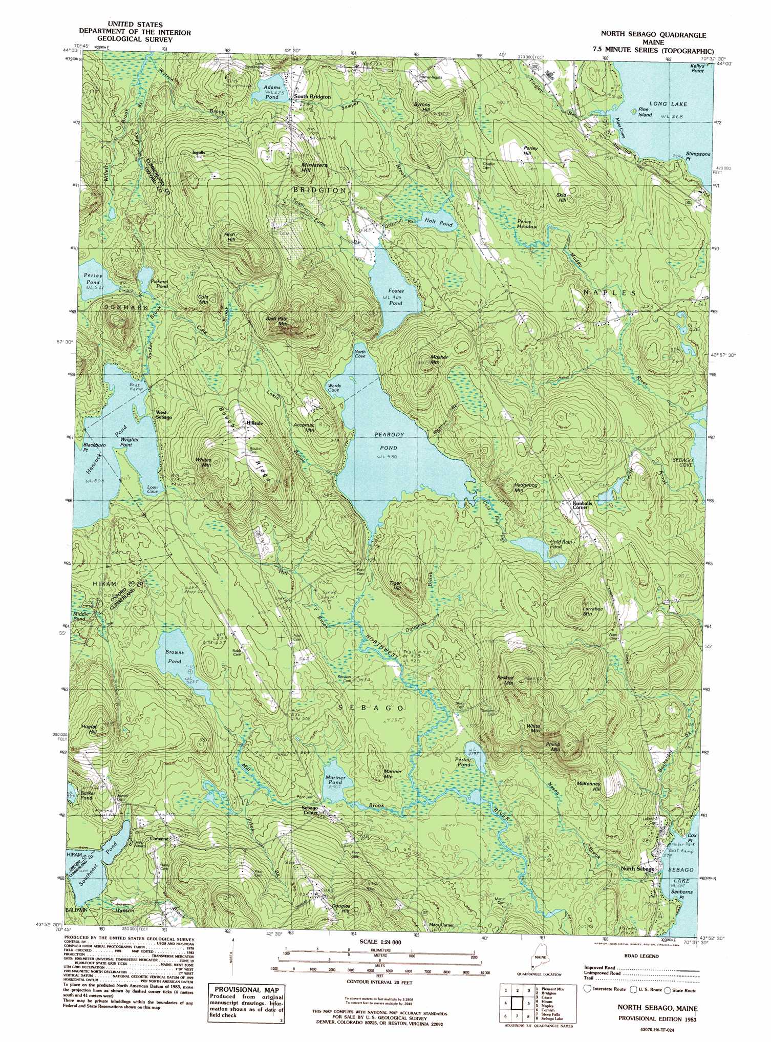
North Sebago Topo Map Maine
To zoom in, hover over the map of North Sebago
USGS Topo Quad 43070h6 - 1:24,000 scale
| Topo Map Name: | North Sebago |
| USGS Topo Quad ID: | 43070h6 |
| Print Size: | ca. 21 1/4" wide x 27" high |
| Southeast Coordinates: | 43.875° N latitude / 70.625° W longitude |
| Map Center Coordinates: | 43.9375° N latitude / 70.6875° W longitude |
| U.S. State: | ME |
| Filename: | o43070h6.jpg |
| Download Map JPG Image: | North Sebago topo map 1:24,000 scale |
| Map Type: | Topographic |
| Topo Series: | 7.5´ |
| Map Scale: | 1:24,000 |
| Source of Map Images: | United States Geological Survey (USGS) |
| Alternate Map Versions: |
North Sebago ME 1983, updated 1984 Download PDF Buy paper map North Sebago ME 1983, updated 1984 Download PDF Buy paper map North Sebago ME 1983, updated 1984 Download PDF Buy paper map North Sebago ME 2011 Download PDF Buy paper map North Sebago ME 2014 Download PDF Buy paper map |
1:24,000 Topo Quads surrounding North Sebago
Center Lovell |
North Waterford |
Ralph |
Norway |
Oxford |
Fryeburg |
Pleasant Mountain |
Bridgton |
Casco |
Mechanic Falls |
Brownfield |
Hiram |
North Sebago |
Naples |
Raymond |
Kezar Falls |
Cornish |
Steep Falls |
Sebago Lake |
North Windham |
West Newfield |
Limerick |
Limington |
Standish |
Gorham |
> Back to 43070e1 at 1:100,000 scale
> Back to 43070a1 at 1:250,000 scale
> Back to U.S. Topo Maps home
North Sebago topo map: Gazetteer
North Sebago: Bays
Loon Cove elevation 153m 501′Mast Cove elevation 82m 269′
North Cove elevation 146m 479′
Wards Cove elevation 146m 479′
North Sebago: Capes
Blackburn Point elevation 153m 501′Cox Point elevation 82m 269′
Sanborns Point elevation 81m 265′
Stimpsons Point elevation 82m 269′
Wrights Point elevation 153m 501′
North Sebago: Dams
Adams Pond Dam elevation 191m 626′Peabody Lake Mill Dam elevation 146m 479′
North Sebago: Islands
Pine Island elevation 82m 269′North Sebago: Lakes
Browns Pond elevation 160m 524′Cold Rain Pond elevation 155m 508′
Foster Pond elevation 143m 469′
Holt Pond elevation 126m 413′
Mariner Pond elevation 128m 419′
Perley Pond elevation 159m 521′
Perley Pond elevation 128m 419′
Southeast Pond elevation 151m 495′
North Sebago: Populated Places
Convene elevation 202m 662′Douglas Hill elevation 283m 928′
Hillside elevation 250m 820′
Ingalls elevation 250m 820′
Kimballs Corner elevation 192m 629′
Macs Corner elevation 217m 711′
North Sebago elevation 85m 278′
Sebago Center elevation 139m 456′
South Bridgton elevation 201m 659′
West Sebago elevation 158m 518′
North Sebago: Reservoirs
Adams Pond elevation 191m 626′Peabody Pond elevation 146m 479′
Pickerel Pond elevation 159m 521′
North Sebago: Ridges
Beech Ridge elevation 275m 902′North Sebago: Streams
Bachelder Brook elevation 81m 265′Cole Brook elevation 228m 748′
Douglass Brook elevation 131m 429′
Gristmill Brook elevation 143m 469′
Hanson Brook elevation 152m 498′
Hill Brook elevation 131m 429′
Lakin Brook elevation 164m 538′
Mill Brook elevation 125m 410′
Muddy River elevation 81m 265′
Nason Brook elevation 81m 265′
Sucker Brook elevation 153m 501′
Sucker Brook elevation 157m 515′
Tingley Brook elevation 82m 269′
Town Farm Brook elevation 143m 469′
Weeman Brook elevation 146m 479′
North Sebago: Summits
Accomac Mountain elevation 214m 702′Bald Pate Mountain elevation 339m 1112′
Byrons Hill elevation 209m 685′
Cole Mountain elevation 211m 692′
Fitch Hill elevation 338m 1108′
Hogfat Hill elevation 284m 931′
Larrabee Mountain elevation 269m 882′
Mariner Mountain elevation 166m 544′
Ministers Hill elevation 260m 853′
Mosher Mountain elevation 152m 498′
Peaked Mountain elevation 330m 1082′
Perley Hill elevation 175m 574′
Philip Mountain elevation 305m 1000′
Poors Hill elevation 299m 980′
Skid Hill elevation 183m 600′
Tiger Hill elevation 224m 734′
White Mountain elevation 319m 1046′
Whites Mountain elevation 305m 1000′
North Sebago: Swamps
Perley Meadow elevation 132m 433′North Sebago digital topo map on disk
Buy this North Sebago topo map showing relief, roads, GPS coordinates and other geographical features, as a high-resolution digital map file on DVD:
Maine, New Hampshire, Rhode Island & Eastern Massachusetts
Buy digital topo maps: Maine, New Hampshire, Rhode Island & Eastern Massachusetts