Steep Falls Topo Map Maine
To zoom in, hover over the map of Steep Falls
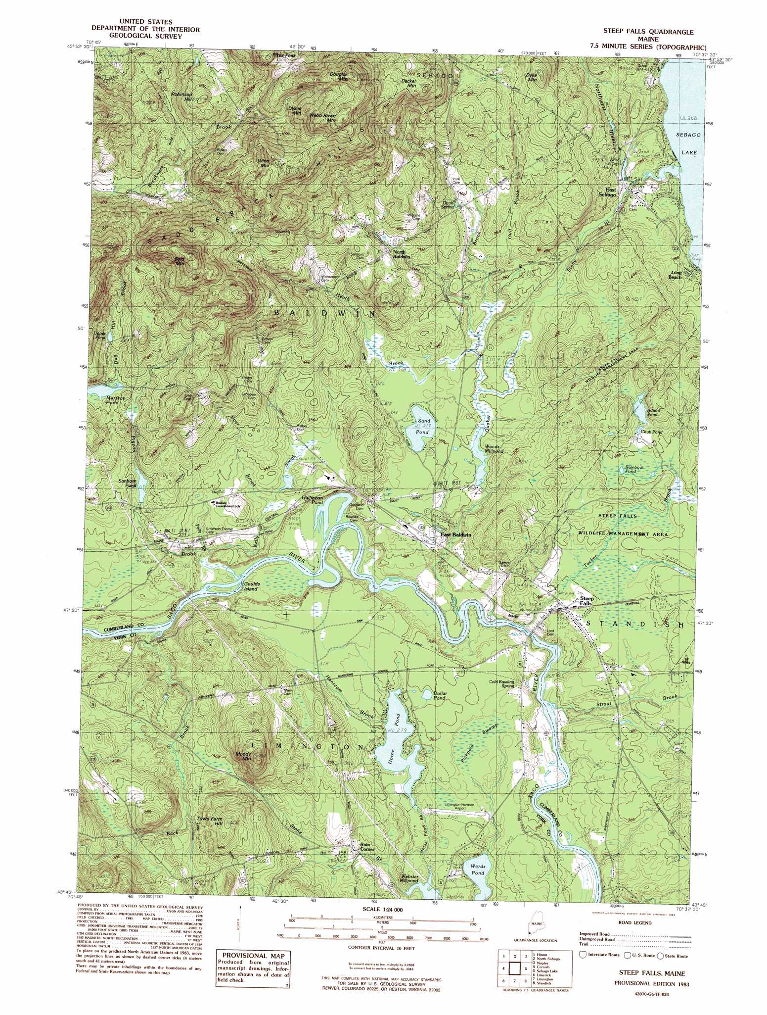
USGS Topo Quad 43070g6 - 1:24,000 scale
| Topo Map Name: | Steep Falls |
| USGS Topo Quad ID: | 43070g6 |
| Print Size: | ca. 21 1/4" wide x 27" high |
| Southeast Coordinates: | 43.75° N latitude / 70.625° W longitude |
| Map Center Coordinates: | 43.8125° N latitude / 70.6875° W longitude |
| U.S. State: | ME |
| Filename: | o43070g6.jpg |
| Download Map JPG Image: | Steep Falls topo map 1:24,000 scale |
| Map Type: | Topographic |
| Topo Series: | 7.5´ |
| Map Scale: | 1:24,000 |
| Source of Map Images: | United States Geological Survey (USGS) |
| Alternate Map Versions: |
Steep Falls ME 1983, updated 1984 Download PDF Buy paper map Steep Falls ME 1983, updated 1984 Download PDF Buy paper map Steep Falls ME 2011 Download PDF Buy paper map Steep Falls ME 2014 Download PDF Buy paper map |
1:24,000 Topo Quads surrounding Steep Falls
Fryeburg |
Pleasant Mountain |
Bridgton |
Casco |
Mechanic Falls |
Brownfield |
Hiram |
North Sebago |
Naples |
Raymond |
Kezar Falls |
Cornish |
Steep Falls |
Sebago Lake |
North Windham |
West Newfield |
Limerick |
Limington |
Standish |
Gorham |
Great East Lake |
Mousam Lake |
Waterboro |
Bar Mills |
Old Orchard Beach |
> Back to 43070e1 at 1:100,000 scale
> Back to 43070a1 at 1:250,000 scale
> Back to U.S. Topo Maps home
Steep Falls topo map: Gazetteer
Steep Falls: Airports
Limington-Harmon Airport elevation 84m 275′Steep Falls: Dams
Dam Number One elevation 88m 288′Pequawket Dam elevation 85m 278′
Steep Falls: Islands
Goulds Island elevation 81m 265′Steep Falls: Lakes
Adams Pond elevation 95m 311′Dollar Pond elevation 90m 295′
Halfmoon Pond elevation 80m 262′
Rainbow Pond elevation 124m 406′
Sand Pond elevation 96m 314′
Wards Pond elevation 71m 232′
Steep Falls: Populated Places
East Baldwin Mattocks Station elevation 95m 311′East Sebago elevation 90m 295′
North Baldwin elevation 156m 511′
Ruin Corner elevation 97m 318′
Steep Falls elevation 90m 295′
Steep Falls: Reservoirs
Chub Pond elevation 94m 308′Fitch Mill Pond elevation 88m 288′
Horne Pond elevation 85m 278′
Sanborn Pond elevation 114m 374′
Upper Pond elevation 197m 646′
Woods Millpond elevation 89m 291′
Steep Falls: Ridges
Saddleback Hills elevation 325m 1066′Steep Falls: Springs
Cold Bowling Spring elevation 73m 239′Davis Spring elevation 122m 400′
Steep Falls: Streams
Back Brook elevation 79m 259′Heath Brook elevation 90m 295′
Heath Brook elevation 91m 298′
Northwest River elevation 81m 265′
Pigeon Brook elevation 81m 265′
Quaker Brook elevation 75m 246′
Strout Brook elevation 71m 232′
Tucker Brook elevation 73m 239′
Steep Falls: Summits
Bald Mountain elevation 374m 1227′Decker Mountain elevation 284m 931′
Douglas Mountain elevation 417m 1368′
Dyke Mountain elevation 217m 711′
Dykes Mountain elevation 350m 1148′
Moody Mountain elevation 211m 692′
Robinson Hill elevation 261m 856′
Town Farm Hill elevation 196m 643′
Webb Rowe Mountain elevation 405m 1328′
Winn Mountain elevation 381m 1250′
Steep Falls: Swamps
Pickpole Swamp elevation 83m 272′Pickpole Swamp elevation 84m 275′
Steep Falls digital topo map on disk
Buy this Steep Falls topo map showing relief, roads, GPS coordinates and other geographical features, as a high-resolution digital map file on DVD:
Maine, New Hampshire, Rhode Island & Eastern Massachusetts
Buy digital topo maps: Maine, New Hampshire, Rhode Island & Eastern Massachusetts