Bridge Topo Map Oregon
To zoom in, hover over the map of Bridge
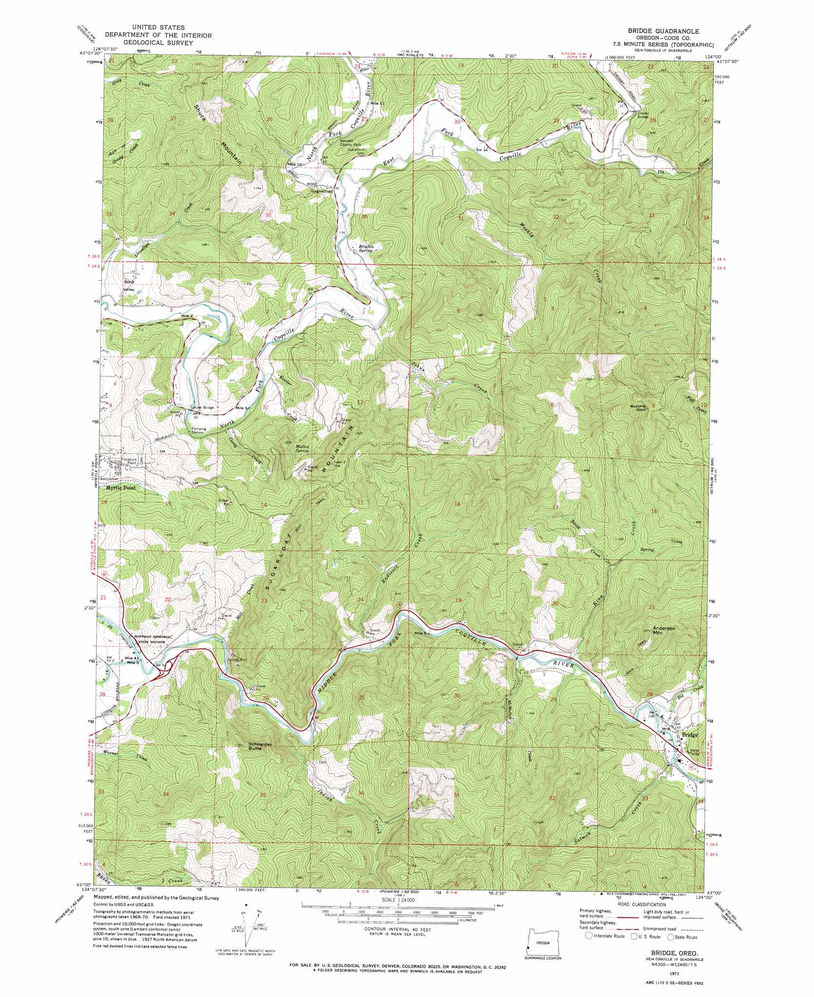
USGS Topo Quad 43124a1 - 1:24,000 scale
| Topo Map Name: | Bridge |
| USGS Topo Quad ID: | 43124a1 |
| Print Size: | ca. 21 1/4" wide x 27" high |
| Southeast Coordinates: | 43° N latitude / 124° W longitude |
| Map Center Coordinates: | 43.0625° N latitude / 124.0625° W longitude |
| U.S. State: | OR |
| Filename: | o43124a1.jpg |
| Download Map JPG Image: | Bridge topo map 1:24,000 scale |
| Map Type: | Topographic |
| Topo Series: | 7.5´ |
| Map Scale: | 1:24,000 |
| Source of Map Images: | United States Geological Survey (USGS) |
| Alternate Map Versions: |
Bridge OR 1971, updated 1973 Download PDF Buy paper map Bridge OR 2011 Download PDF Buy paper map Bridge OR 2014 Download PDF Buy paper map |
1:24,000 Topo Quads surrounding Bridge
Charleston |
Coos Bay |
Daniels Creek |
Coos Mountain |
Tioga |
Riverton |
Coquille |
Mckinley |
Dora |
Sitkum |
Bill Peak |
Myrtle Point |
Bridge |
Remote |
Kenyon Mountain |
Calf Ranch Mountain |
Dement Creek |
Powers |
Rasler Creek |
Bone Mountain |
Mount Butler |
Barklow Mountain |
China Flat |
Eden Ridge Valley |
Mount Bolivar |
> Back to 43124a1 at 1:100,000 scale
> Back to 43124a1 at 1:250,000 scale
> Back to U.S. Topo Maps home
Bridge topo map: Gazetteer
Bridge: Bridges
Cooper Bridge elevation 10m 32′Crosby Bridge elevation 12m 39′
Bridge: Parks
Bennett County Park elevation 21m 68′Hoffman Memorial State Park elevation 18m 59′
Bridge: Pillars
Buzzard Rock elevation 493m 1617′Bridge: Populated Places
Bridge elevation 47m 154′Gravelford elevation 17m 55′
Bridge: Post Offices
Angora Post Office (historical) elevation 45m 147′Bridge Post Office (historical) elevation 47m 154′
Enchanted Prairie Post Office (historical) elevation 43m 141′
Gravelford Post Office (historical) elevation 17m 55′
Hermansville Post Office (historical) elevation 12m 39′
Oak Post Office (historical) elevation 43m 141′
Bridge: Springs
Brights Spring elevation 28m 91′Mullen Spring elevation 200m 656′
Bridge: Streams
Big Creek elevation 33m 108′Carey Creek elevation 14m 45′
East Fork Coquille River elevation 13m 42′
Elk Creek elevation 12m 39′
Endicott Creek elevation 24m 78′
Indian Creek elevation 16m 52′
Johns Creek elevation 13m 42′
Kessler Creek elevation 13m 42′
King Creek elevation 26m 85′
McMullen Creek elevation 26m 85′
Middle Fork Coquille River elevation 8m 26′
Mill Creek elevation 9m 29′
Salmon Creek elevation 37m 121′
Smith Creek elevation 59m 193′
Spring Creek elevation 70m 229′
Weekly Creek elevation 14m 45′
Wimer Creek elevation 14m 45′
Yankee Run elevation 16m 52′
Bridge: Summits
Anderson Mountain elevation 427m 1400′Schneider Butte elevation 346m 1135′
Sugarloaf Mountain elevation 446m 1463′
Bridge: Valleys
Echo Valley elevation 13m 42′Bridge digital topo map on disk
Buy this Bridge topo map showing relief, roads, GPS coordinates and other geographical features, as a high-resolution digital map file on DVD: