Red Ives Peak Topo Map Idaho
To zoom in, hover over the map of Red Ives Peak
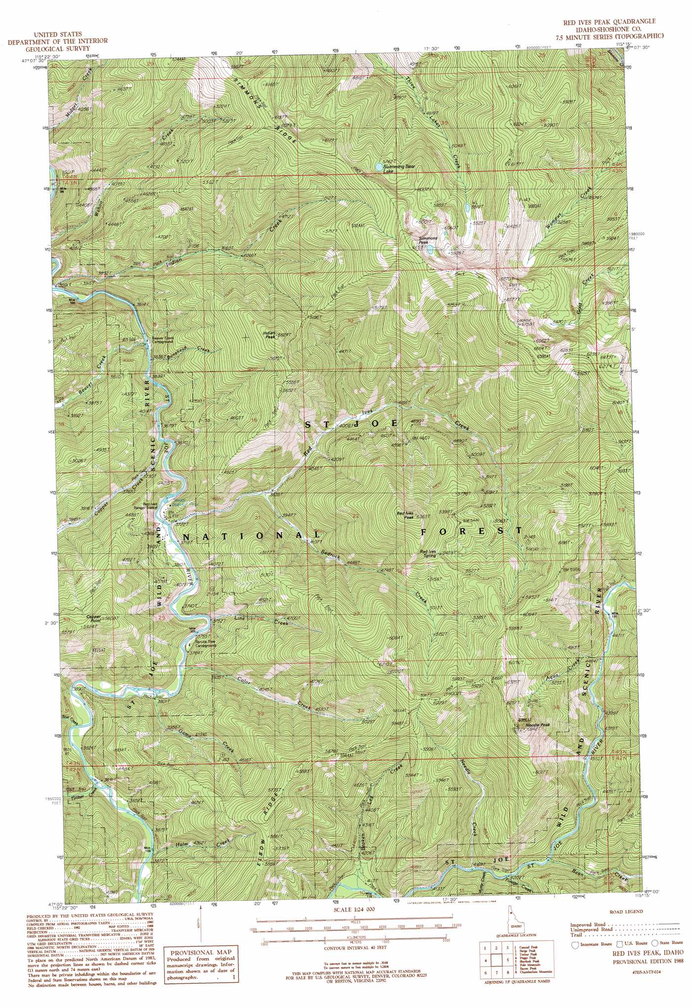
USGS Topo Quad 47115a3 - 1:24,000 scale
| Topo Map Name: | Red Ives Peak |
| USGS Topo Quad ID: | 47115a3 |
| Print Size: | ca. 21 1/4" wide x 27" high |
| Southeast Coordinates: | 47° N latitude / 115.25° W longitude |
| Map Center Coordinates: | 47.0625° N latitude / 115.3125° W longitude |
| U.S. State: | ID |
| Filename: | o47115a3.jpg |
| Download Map JPG Image: | Red Ives Peak topo map 1:24,000 scale |
| Map Type: | Topographic |
| Topo Series: | 7.5´ |
| Map Scale: | 1:24,000 |
| Source of Map Images: | United States Geological Survey (USGS) |
| Alternate Map Versions: |
Red Ives Peak ID 1988, updated 1988 Download PDF Buy paper map Red Ives Peak ID 1995, updated 1997 Download PDF Buy paper map Red Ives Peak ID 2011 Download PDF Buy paper map Red Ives Peak ID 2013 Download PDF Buy paper map |
| FStopo: | US Forest Service topo Red Ives Peak is available: Download FStopo PDF Download FStopo TIF |
1:24,000 Topo Quads surrounding Red Ives Peak
Adair |
Mcgee Peak |
Deborgia South |
Boyd Mountain |
Saint Regis |
Thor Mountain |
Conrad Peak |
Berge Peak |
Torino Peak |
Wilson Gulch |
Bathtub Mountain |
Peggy Peak |
Red Ives Peak |
Sherlock Peak |
Illinois Peak |
Mallard Peak |
Pole Mountain |
Bacon Peak |
Chamberlain Mountain |
Hoodoo Pass |
Sheep Mountain |
The Nub |
Elizabeth Lake |
Moose Mountain |
Osier Ridge |
> Back to 47115a1 at 1:100,000 scale
> Back to 47114a1 at 1:250,000 scale
> Back to U.S. Topo Maps home
Red Ives Peak topo map: Gazetteer
Red Ives Peak: Lakes
Swimming Bear Lake elevation 1737m 5698′Red Ives Peak: Parks
Saint Joe Wild and Scenic River elevation 1242m 4074′Red Ives Peak: Ridges
Elbow Ridge elevation 1697m 5567′Red Ives Peak: Springs
Red Ives Spring elevation 1686m 5531′Red Ives Peak: Streams
Aqua Creek elevation 1359m 4458′Bean Creek elevation 1369m 4491′
Beaver Creek elevation 1103m 3618′
Bedrock Creek elevation 1169m 3835′
Bonehead Creek elevation 1107m 3631′
Broken Leg Creek elevation 1250m 4101′
Color Creek elevation 1151m 3776′
Copper Creek elevation 1119m 3671′
Forage Creek elevation 1331m 4366′
Game Creek elevation 1155m 3789′
Halm Creek elevation 1176m 3858′
Indian Creek elevation 1095m 3592′
Line Creek elevation 1154m 3786′
Myrtle Creek elevation 1341m 4399′
Needle Creek elevation 1348m 4422′
Red Ives Creek elevation 1133m 3717′
Scat Creek elevation 1170m 3838′
Timber Creek elevation 1172m 3845′
Red Ives Peak: Summits
Copper Point elevation 1710m 5610′Indian Peak elevation 1754m 5754′
Needle Peak elevation 1956m 6417′
Red Ives Peak elevation 1920m 6299′
Simmons Peak elevation 2027m 6650′
Red Ives Peak digital topo map on disk
Buy this Red Ives Peak topo map showing relief, roads, GPS coordinates and other geographical features, as a high-resolution digital map file on DVD: