Cumberland Topo Map Washington
To zoom in, hover over the map of Cumberland
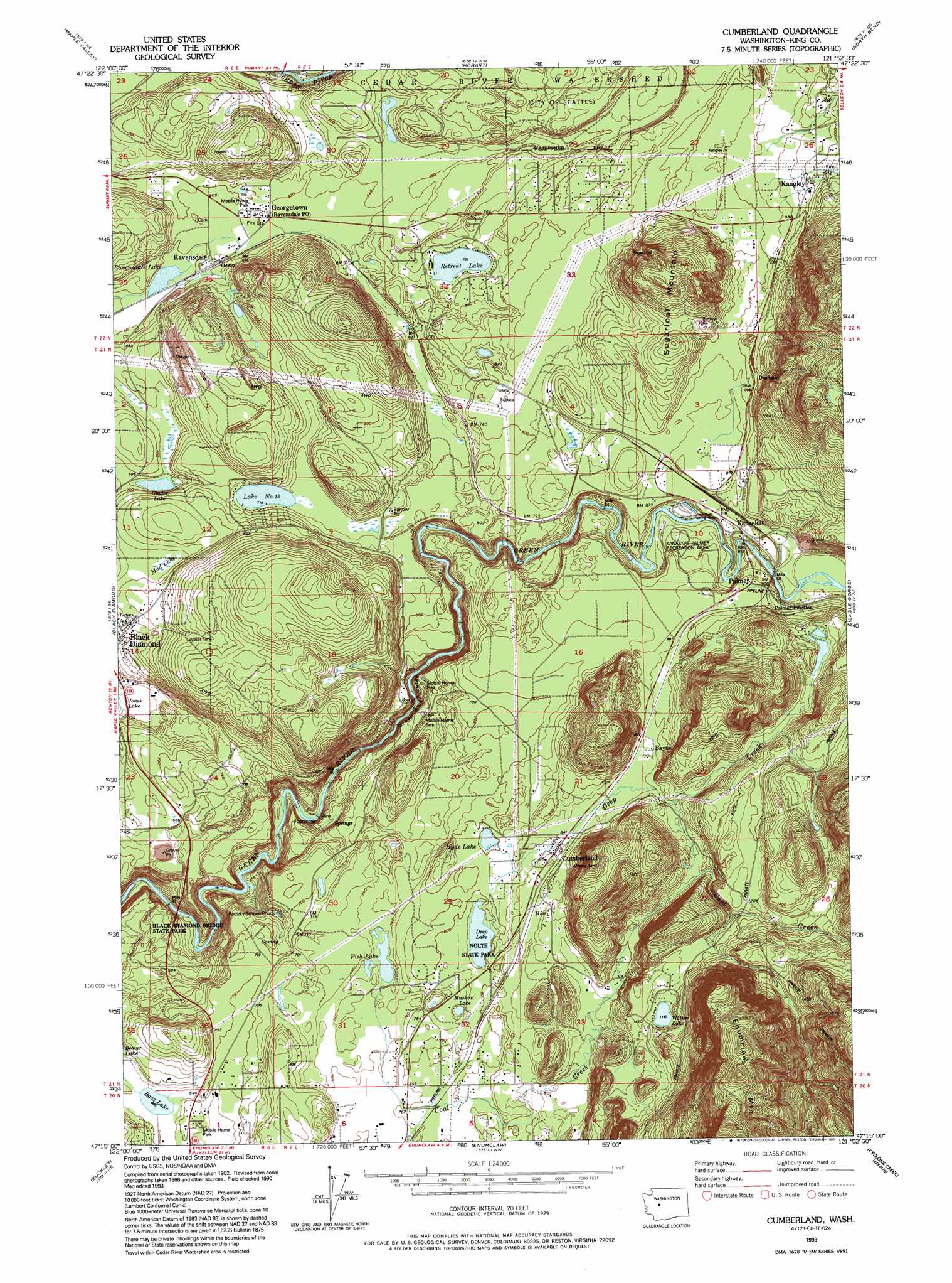
USGS Topo Quad 47121c8 - 1:24,000 scale
| Topo Map Name: | Cumberland |
| USGS Topo Quad ID: | 47121c8 |
| Print Size: | ca. 21 1/4" wide x 27" high |
| Southeast Coordinates: | 47.25° N latitude / 121.875° W longitude |
| Map Center Coordinates: | 47.3125° N latitude / 121.9375° W longitude |
| U.S. State: | WA |
| Filename: | o47121c8.jpg |
| Download Map JPG Image: | Cumberland topo map 1:24,000 scale |
| Map Type: | Topographic |
| Topo Series: | 7.5´ |
| Map Scale: | 1:24,000 |
| Source of Map Images: | United States Geological Survey (USGS) |
| Alternate Map Versions: |
Cumberland WA 1953, updated 1955 Download PDF Buy paper map Cumberland WA 1953, updated 1967 Download PDF Buy paper map Cumberland WA 1953, updated 1969 Download PDF Buy paper map Cumberland WA 1953, updated 1976 Download PDF Buy paper map Cumberland WA 1993, updated 1993 Download PDF Buy paper map Cumberland WA 2011 Download PDF Buy paper map Cumberland WA 2014 Download PDF Buy paper map |
1:24,000 Topo Quads surrounding Cumberland
Issaquah |
Fall City |
Snoqualmie |
Mount Si |
|
Renton |
Maple Valley |
Hobart |
North Bend |
Chester Morse Lake |
Auburn |
Black Diamond |
Cumberland |
Eagle Gorge |
Cougar Mountain |
Sumner |
Buckley |
Enumclaw |
Cyclone Creek |
Greenwater |
Orting |
Wilkeson |
Old Baldy Mountain |
Bearhead Mountain |
Clear West Peak |
> Back to 47121a1 at 1:100,000 scale
> Back to 47120a1 at 1:250,000 scale
> Back to U.S. Topo Maps home
Cumberland topo map: Gazetteer
Cumberland: Dams
Green River Rearing Pond Dam elevation 231m 757′Ravensdale Pit Dam elevation 182m 597′
Cumberland: Lakes
Bass Lake elevation 204m 669′Deep Lake elevation 236m 774′
Fish Lake elevation 217m 711′
Ginder Lake elevation 207m 679′
Hyde Lake elevation 243m 797′
Lake Number Twelve elevation 220m 721′
Little Retreat Lake elevation 205m 672′
Mud Lake elevation 230m 754′
Muskrat Lake elevation 224m 734′
Ravensdale Lake elevation 181m 593′
Retreat Lake elevation 224m 734′
Walker Lake elevation 349m 1145′
Cumberland: Parks
Green River Gorge Conservation Area elevation 151m 495′Green River Gorge State Park elevation 138m 452′
Kanaskat-Palmer Recreation Area elevation 255m 836′
Kanaskat-Palmer State Park elevation 245m 803′
Nolte State Park elevation 240m 787′
Cumberland: Populated Places
Bayne elevation 268m 879′Bayne Junction elevation 271m 889′
Cumberland elevation 259m 849′
Durham elevation 288m 944′
Franklin elevation 186m 610′
Georgetown elevation 190m 623′
Kanaskat elevation 253m 830′
Kanaskat Junction elevation 281m 921′
Kangley elevation 308m 1010′
Landsburg elevation 159m 521′
Naco elevation 262m 859′
Palmer elevation 270m 885′
Palmer Junction elevation 274m 898′
Ravensdale elevation 190m 623′
Cumberland: Post Offices
Ravensdale Post Office elevation 190m 623′Cumberland: Reservoirs
Green River Rearing Pond elevation 231m 757′Green River Rearing Ponds elevation 238m 780′
Pautzky Salmon Ponds elevation 210m 688′
Ravensdale Pit elevation 182m 597′
Cumberland: Streams
Coal Creek elevation 219m 718′Deep Creek elevation 236m 774′
Franklin Creek elevation 145m 475′
Green River Gorge elevation 116m 380′
Cumberland: Summits
Enumclaw Mountain elevation 849m 2785′Sugarloaf Mountain elevation 451m 1479′
Cumberland digital topo map on disk
Buy this Cumberland topo map showing relief, roads, GPS coordinates and other geographical features, as a high-resolution digital map file on DVD: