Indiana topographic maps
These topographic index maps for Indiana state are provided by the U.S. Geological Survey (USGS) for map sheet identification. To locate the USGS topo quad in Indiana that you are trying to find, look at the index map of the appropriate map scale.
1:24,000 scale Indiana topo quads
The index map below is for Indiana topo quads at 1:24,000 scale. It is zoomable, and you can find the name of the 1:24,000 scale map (sometimes abbreviated as "24k") written diagonally across rectangular boxes that define the borders of the individual 24k map sheets.
Note that a rare few of the 1:24,000 scale (aka 7.5 minute) maps in Indiana state might actually be at 1:25,000 scale, which is a very minor difference in map scale. Some of these 1:25,000 scale maps also cover a larger area than regular 7.5 minute maps. Those maps are 7.5´x15´ topo quads, and can be identified on the index map below by a larger sized rectangle that is twice as wide as usual (covers twice the longitude). The map names for these sheets are labelled horizontally, not diagonally.
Indiana Topo Index Map: 1:24,000

Hover over the index map to the left to view detailed zoom.
You can also download this index map here:
Indiana topo index map at 1:24,000 Scale
24k IN topographic maps:
(This is a small selection to get you started. Use the complete list of 250k or 100k maps further below to drill down to your area of choice.)
41087f4 Whiting, IN
41087f2 Ogden Dunes, IN
41087f1 Dune Acres, IN
41086f8 Michigan City West, IN
41086f7 Michigan City East, IN
41086f6 Springville, IN
41086f5 New Carlisle, IN
41086f4 Lydick, IN
41086f3 South Bend West, IN
41086f2 South Bend East, IN
41086f1 Osceola, IN
41085f8 Elkhart, IN
41085f7 Bristol, IN
41085f6 Middlebury, IN
41085f5 Shipshewana, IN
41085f4 Lagrange, IN
41085f3 Mongo, IN
41085f2 Orland, IN
41085f1 Angola West, IN
41084f8 Angola East, IN
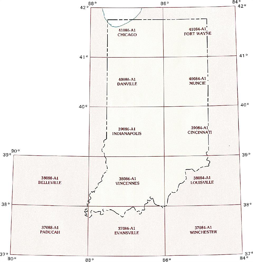
1:250,000 scale Indiana topo maps
Below you can find the 1:250,000 index map for Indiana state. These topo maps give a general overview of an area and cover a large area: 1° latitude by 2° longitude. A list of all Indiana topo map sheets at 250k follows on the right.
Indiana Topo Index Map: 1:250,000
Hover over the index map to the left to view detailed zoom.
You can also download this index map here:
Indiana topo index map at 1:250,000 Scale
250k IN topographic maps:
41086a1 Chicago, IN
41084a1 Ft Wayne, IN
40086a1 Danville, IN
40084a1 Muncie, IN
39086a1 Indianapolis, IN
39084a1 Cincinnati, IN
38086a1 Vincennes, IN
38084a1 Louisville, IN
37088a1 Paducah, IN
37086a1 Evansville, IN
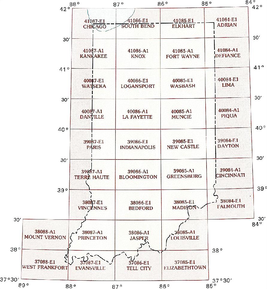
1:100,000 scale Indiana topo maps
Below you can find the 1:100,000 index map for Indiana state. These topo maps give a more detailed overview of an area and cover a medium-sized area: 0.5° latitude by 1° longitude. A list of all Indiana topo map sheets at 100k follows on the right.
Indiana Topo Index Map: 1:100,000
Hover over the index map to the left to view detailed zoom.
You can also download this index map here:
Indiana topo index map at 1:100,000 Scale
100k IN topographic maps:
41087e1 Chicago, IN
41086e1 South Bend, IN
41085e1 Elkhart, IN
41084e1 Adrian, IN
41087a1 Kankakee, IN
41086a1 Knox, IN
41085a1 Fort Wayne, IN
41084a1 Defiance, IN
40087e1 Watseka, IN
40086e1 Logansport, IN
40085e1 Wabash, IN
40084e1 Lima, IN
40087a1 Danville, IN
40086a1 La Fayette, IN
40085a1 Muncie, IN
40084a1 Piqua, IN
39087e1 Paris, IN
39086e1 Indianapolis, IN
39085e1 New Castle, IN
39084e1 Dayton, IN
39087a1 Terre Haute, IN
39086a1 Bloomington, IN
39085a1 Greensburg, IN
39084a1 Cincinnati, IN
38087e1 Vincennes, IN
38086e1 Bedford, IN
38085e1 Madison, IN
38084e1 Falmouth, IN
38088a1 Mount Vernon, IN
38087a1 Princeton, IN
38086a1 Jasper, IN
38085a1 Louisville, IN
37088e1 West Frankfort, IN
37087e1 Evansville, IN
37086e1 Tell City, IN