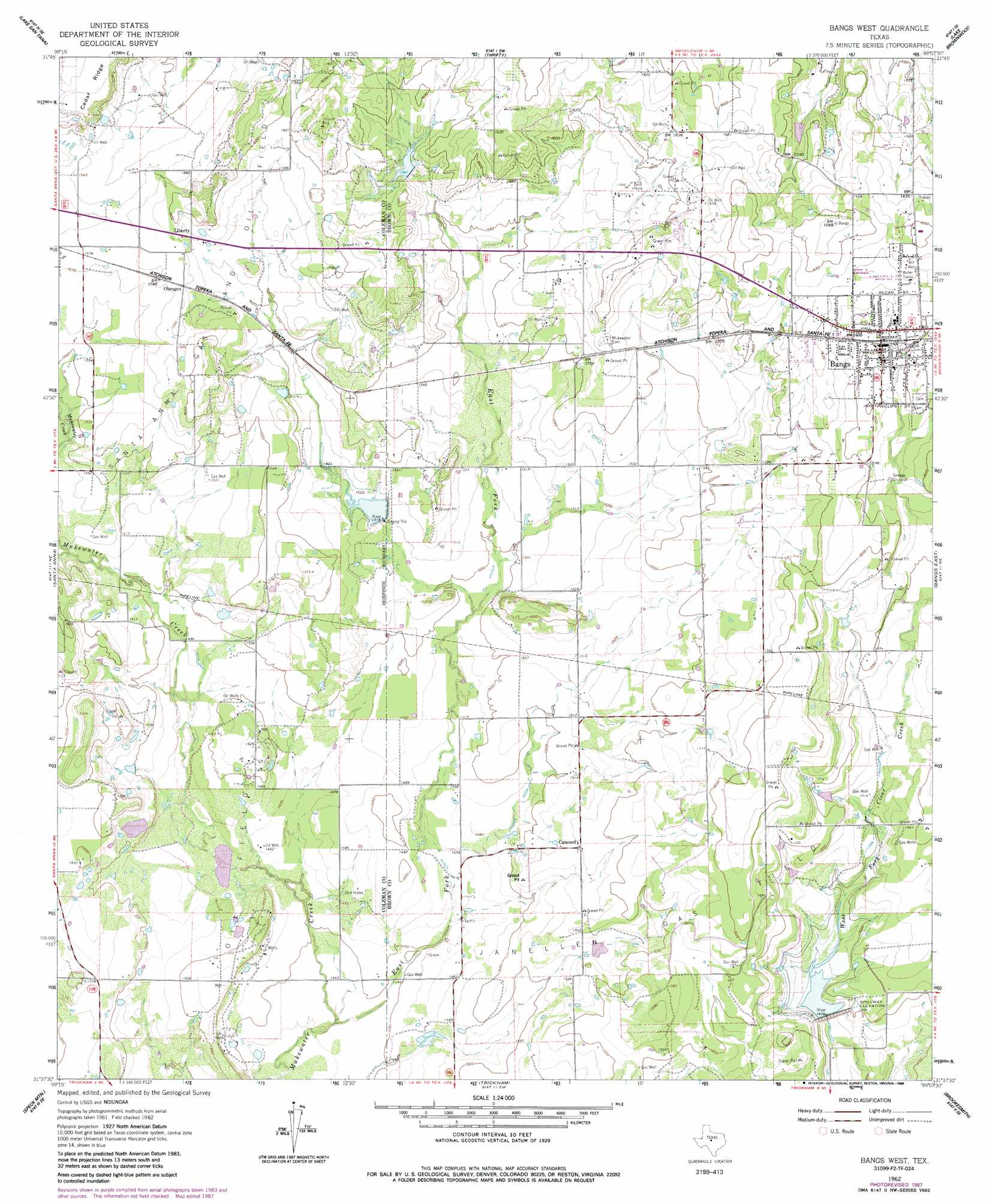
Bangs West Topo Map Texas
To zoom in, hover over the map of Bangs West
USGS Topo Quad 31099f2 - 1:24,000 scale
| Topo Map Name: | Bangs West |
| USGS Topo Quad ID: | 31099f2 |
| Print Size: | ca. 21 1/4" wide x 27" high |
| Southeast Coordinates: | 31.625° N latitude / 99.125° W longitude |
| Map Center Coordinates: | 31.6875° N latitude / 99.1875° W longitude |
| U.S. State: | TX |
| Filename: | o31099f2.jpg |
| Download Map JPG Image: | Bangs West topo map 1:24,000 scale |
| Map Type: | Topographic |
| Topo Series: | 7.5´ |
| Map Scale: | 1:24,000 |
| Source of Map Images: | United States Geological Survey (USGS) |
| Alternate Map Versions: |
Bangs West TX 1962, updated 1964 Download PDF Buy paper map Bangs West TX 1962, updated 1978 Download PDF Buy paper map Bangs West TX 1962, updated 1988 Download PDF Buy paper map Bangs West TX 2010 Download PDF Buy paper map Bangs West TX 2013 Download PDF Buy paper map Bangs West TX 2016 Download PDF Buy paper map |
1:24,000 Topo Quads surrounding Bangs West
Lake Scarborough |
Coleman Ne |
Burkett |
Byrds |
May |
Coleman |
Lake San Tana |
Thrifty |
Lake Brownwood |
Owens |
Fisk |
Santa Anna |
Bangs West |
Bangs East |
Brownwood |
Gouldbusk |
Speck Mountain |
Trickham |
Brookesmith |
Indian Creek |
Fife |
Whon |
Mercury |
Elm Grove |
Bowser |
> Back to 31099e1 at 1:100,000 scale
> Back to 31098a1 at 1:250,000 scale
> Back to U.S. Topo Maps home
Bangs West topo map: Gazetteer
Bangs West: Dams
Owens Lake Dam elevation 468m 1535′Soil Conservation Service Site 10a Dam elevation 446m 1463′
Soil Conservation Service Site 4 Dam elevation 451m 1479′
Soil Conservation Service Site 7 Dam elevation 485m 1591′
Soil Conservation Service Site 9 Dam elevation 466m 1528′
Bangs West: Oilfields
Janellen Gas Field elevation 467m 1532′Santa Anna Gas and Oil Field elevation 477m 1564′
Bangs West: Parks
Dragon Memorial Stadium elevation 493m 1617′Bangs West: Populated Places
Bangs elevation 490m 1607′Liberty elevation 480m 1574′
Obregon elevation 482m 1581′
Bangs West: Reservoirs
Owens Lake elevation 468m 1535′Soil Conservation Service Site 10a Reservoir elevation 446m 1463′
Soil Conservation Service Site 4 Reservoir elevation 451m 1479′
Soil Conservation Service Site 7 Reservoir elevation 485m 1591′
Soil Conservation Service Site 9 Reservoir elevation 466m 1528′
Bangs West: Streams
East Fork Mukewater Creek elevation 437m 1433′Bangs West digital topo map on disk
Buy this Bangs West topo map showing relief, roads, GPS coordinates and other geographical features, as a high-resolution digital map file on DVD: