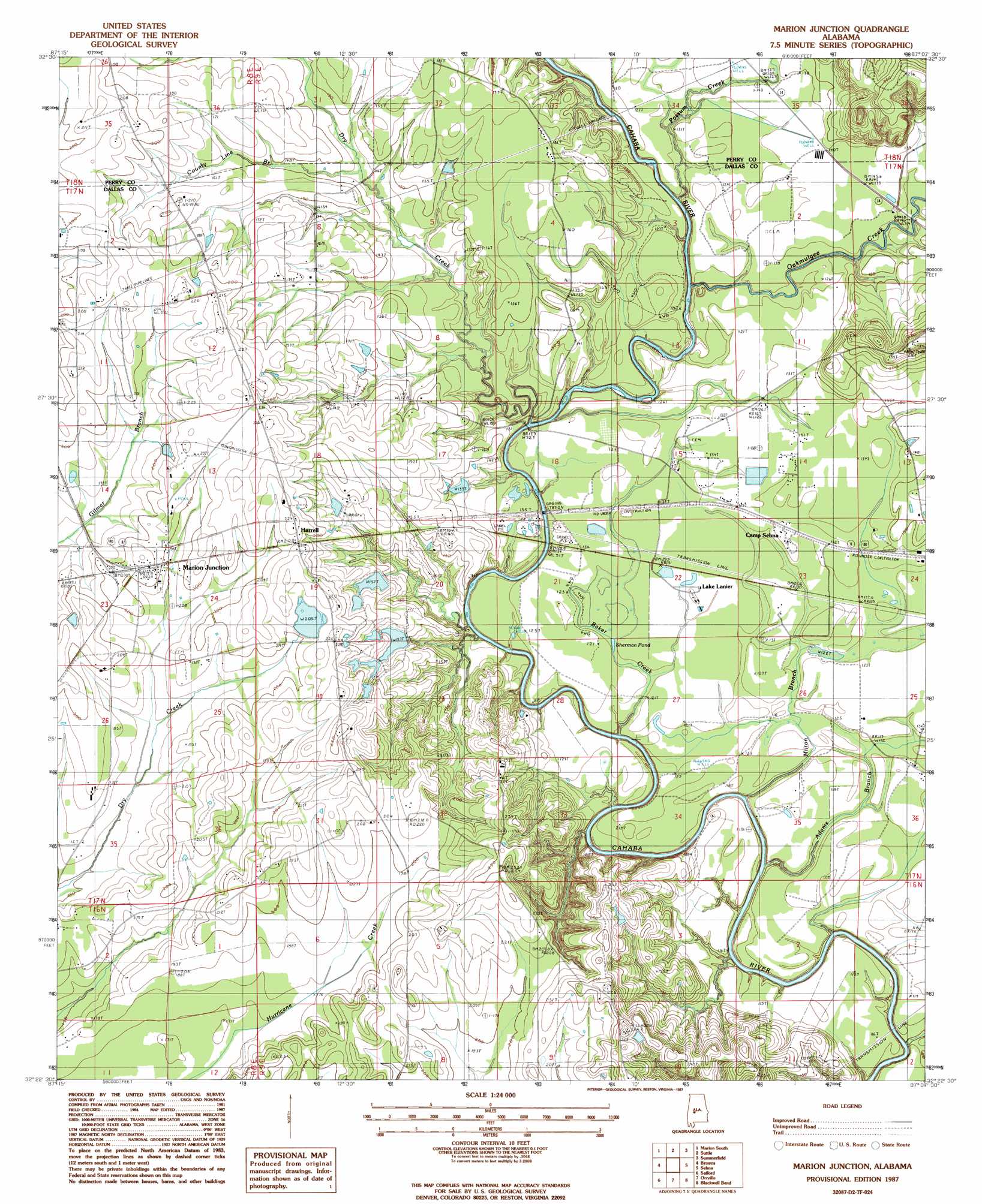
Marion Junction Topo Map Alabama
To zoom in, hover over the map of Marion Junction
USGS Topo Quad 32087d2 - 1:24,000 scale
| Topo Map Name: | Marion Junction |
| USGS Topo Quad ID: | 32087d2 |
| Print Size: | ca. 21 1/4" wide x 27" high |
| Southeast Coordinates: | 32.375° N latitude / 87.125° W longitude |
| Map Center Coordinates: | 32.4375° N latitude / 87.1875° W longitude |
| U.S. State: | AL |
| Filename: | o32087d2.jpg |
| Download Map JPG Image: | Marion Junction topo map 1:24,000 scale |
| Map Type: | Topographic |
| Topo Series: | 7.5´ |
| Map Scale: | 1:24,000 |
| Source of Map Images: | United States Geological Survey (USGS) |
| Alternate Map Versions: |
Selma NW AL 1975, updated 1977 Download PDF Buy paper map Marion Junction AL 1987, updated 1987 Download PDF Buy paper map Marion Junction AL 2011 Download PDF Buy paper map Marion Junction AL 2014 Download PDF Buy paper map |
1:24,000 Topo Quads surrounding Marion Junction
Morgan Springs |
Marion North |
Sprott |
Buck Creek |
Plantersville |
Scott Station |
Marion South |
Suttle |
Summerfield |
Jones |
Uniontown East |
Browns |
Marion Junction |
Selma |
Burnsville |
Central Mills |
Safford |
Orrville |
Blackwell Bend |
Sardis |
Catherine |
Crumptonia |
Tasso |
Elm Bluff |
Pleasant Hill |
> Back to 32087a1 at 1:100,000 scale
> Back to 32086a1 at 1:250,000 scale
> Back to U.S. Topo Maps home
Marion Junction topo map: Gazetteer
Marion Junction: Crossings
Fortune Ferry (historical) elevation 34m 111′Purnells Ferry (historical) elevation 29m 95′
Marion Junction: Dams
J M Gaston Number 1 Dam elevation 55m 180′J M Gaston Number 2 Dam elevation 64m 209′
Marion Junction: Lakes
Lake Lanier elevation 39m 127′Sherman Pond elevation 37m 121′
Marion Junction: Populated Places
Harrell elevation 68m 223′Marion Junction elevation 63m 206′
Pernell elevation 50m 164′
Marion Junction: Post Offices
Marion Junction Post Office elevation 63m 206′Marion Junction: Reservoirs
J M Gaston Number One Lake elevation 55m 180′J M Gaston Number Two Lake elevation 64m 209′
Marion Junction: Streams
Adams Branch elevation 28m 91′Baker Creek elevation 27m 88′
County Line Branch elevation 40m 131′
Dry Creek elevation 30m 98′
Milton Branch elevation 27m 88′
Oakmulgee Creek elevation 36m 118′
Possum Creek elevation 30m 98′
Marion Junction digital topo map on disk
Buy this Marion Junction topo map showing relief, roads, GPS coordinates and other geographical features, as a high-resolution digital map file on DVD:
Gulf Coast (LA, MS, AL, FL) & Southwestern Georgia
Buy digital topo maps: Gulf Coast (LA, MS, AL, FL) & Southwestern Georgia
 & Southwestern Georgia map DVD")