Sandy Springs Topo Map Georgia
To zoom in, hover over the map of Sandy Springs
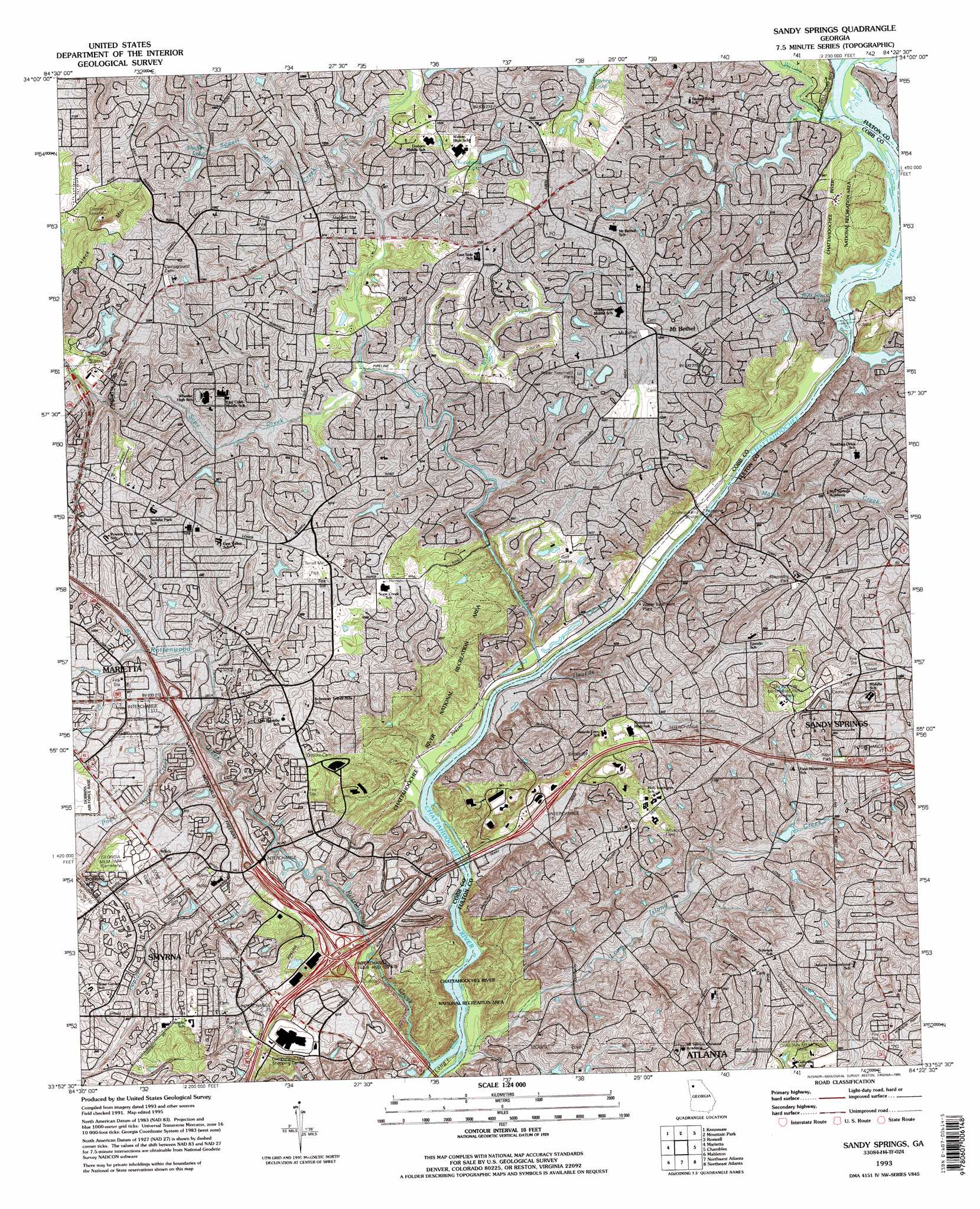
USGS Topo Quad 33084h4 - 1:24,000 scale
| Topo Map Name: | Sandy Springs |
| USGS Topo Quad ID: | 33084h4 |
| Print Size: | ca. 21 1/4" wide x 27" high |
| Southeast Coordinates: | 33.875° N latitude / 84.375° W longitude |
| Map Center Coordinates: | 33.9375° N latitude / 84.4375° W longitude |
| U.S. State: | GA |
| Filename: | o33084h4.jpg |
| Download Map JPG Image: | Sandy Springs topo map 1:24,000 scale |
| Map Type: | Topographic |
| Topo Series: | 7.5´ |
| Map Scale: | 1:24,000 |
| Source of Map Images: | United States Geological Survey (USGS) |
| Alternate Map Versions: |
Sandy Springs GA 1955, updated 1957 Download PDF Buy paper map Sandy Springs GA 1955, updated 1964 Download PDF Buy paper map Sandy Springs GA 1955, updated 1969 Download PDF Buy paper map Sandy Springs GA 1955, updated 1974 Download PDF Buy paper map Sandy Springs GA 1955, updated 1977 Download PDF Buy paper map Sandy Springs GA 1955, updated 1983 Download PDF Buy paper map Sandy Springs GA 1993, updated 1995 Download PDF Buy paper map Sandy Springs GA 1997, updated 1999 Download PDF Buy paper map Sandy Springs GA 2011 Download PDF Buy paper map Sandy Springs GA 2014 Download PDF Buy paper map |
1:24,000 Topo Quads surrounding Sandy Springs
Allatoona Dam |
South Canton |
Canton |
Birmingham |
Cumming |
Acworth |
Kennesaw |
Mountain Park |
Roswell |
Duluth |
Lost Mountain |
Marietta |
Sandy Springs |
Chamblee |
Norcross |
Austell |
Mableton |
Northwest Atlanta |
Northeast Atlanta |
Stone Mountain |
Campbellton |
Ben Hill |
Southwest Atlanta |
Southeast Atlanta |
Redan |
> Back to 33084e1 at 1:100,000 scale
> Back to 33084a1 at 1:250,000 scale
> Back to U.S. Topo Maps home
Sandy Springs topo map: Gazetteer
Sandy Springs: Airports
Galleria Heliport elevation 296m 971′Interstate North Heliport elevation 266m 872′
Parkaire Field (historical) elevation 324m 1062′
Ruffwood Heliport elevation 238m 780′
Sandy Springs: Bars
Chochran Shoals elevation 236m 774′Devils Race Course Shoals elevation 232m 761′
Long Island Shoals elevation 231m 757′
Thornton Shoals elevation 240m 787′
Sandy Springs: Bridges
Johnson Ferry Bridge elevation 242m 793′Sandy Springs: Crossings
Heard Ferry (historical) elevation 239m 784′Interchange 13 elevation 283m 928′
Interchange 14 elevation 274m 898′
Interchange 15 elevation 262m 859′
Interchange 16 elevation 310m 1017′
Interchange 17 elevation 289m 948′
Interchange 78 elevation 295m 967′
Interchange 79 elevation 290m 951′
Johnson Ferry (historical) elevation 242m 793′
Power Ferry (historical) elevation 236m 774′
Sandy Springs: Dams
Berezney and Lee Lake Dam elevation 280m 918′Camp Bert Adams Dam elevation 297m 974′
Elarbee Lake Dam elevation 258m 846′
Hampton Lake Dam elevation 294m 964′
Lake Jackson Dam elevation 263m 862′
Morgan Falls Dam elevation 259m 849′
Morgan Falls Dam elevation 259m 849′
Orkin Lake Dam elevation 255m 836′
Sheffer Lake Dam elevation 308m 1010′
Thompson Lake Dam elevation 296m 971′
Willow Point Lake Dam elevation 278m 912′
Sandy Springs: Parks
Abernathy Park elevation 314m 1030′Allen Park elevation 290m 951′
Fullers Park elevation 293m 961′
Jonquil Park elevation 302m 990′
Lake Forest Park elevation 287m 941′
Mount Bethel Park elevation 319m 1046′
Sewell Park elevation 312m 1023′
Terrell Mill Park elevation 308m 1010′
Sandy Springs: Populated Places
Ashebrook elevation 295m 967′Blakeford elevation 317m 1040′
Cameron Glen elevation 290m 951′
Chattahoochee Heights elevation 312m 1023′
Chattahoochee Plantation elevation 260m 853′
Chimney Trace elevation 311m 1020′
Coldstream elevation 306m 1003′
Country Park elevation 312m 1023′
Countryside at Cumberland elevation 310m 1017′
Crossgate elevation 298m 977′
Cumberland Bridge elevation 295m 967′
Cumberland Hill elevation 291m 954′
East Conway Hill elevation 297m 974′
Farmstead elevation 306m 1003′
Forest Brook elevation 305m 1000′
Glen Errol elevation 293m 961′
Glencastle Estates elevation 260m 853′
Greyfield elevation 321m 1053′
Hampton Farms elevation 306m 1003′
Hampton Lake elevation 311m 1020′
Heritage elevation 298m 977′
Heritage Glen elevation 315m 1033′
Idlewood Vally elevation 273m 895′
Indian Hills elevation 300m 984′
Lake Colony elevation 304m 997′
Lake Island Estates elevation 284m 931′
Laurel Brook elevation 311m 1020′
McIvor (historical) elevation 309m 1013′
Millbrook elevation 304m 997′
Millridge elevation 317m 1040′
Misty Ridge elevation 313m 1026′
Montwicke elevation 315m 1033′
Mount Bethel elevation 320m 1049′
Northwest Park elevation 316m 1036′
Oaks of Cumberland elevation 296m 971′
Post Harbor elevation 258m 846′
Post River elevation 269m 882′
Postwoods elevation 255m 836′
Powers Ferry Vantage elevation 274m 898′
Powers Lane elevation 299m 980′
Princeton Lakes elevation 312m 1023′
Princeton Walk elevation 304m 997′
River Chase elevation 285m 935′
Riverhill elevation 321m 1053′
Riverside elevation 295m 967′
Riverwood elevation 282m 925′
Rose Garden Hills elevation 311m 1020′
Salem Woods elevation 299m 980′
Sandy Springs elevation 334m 1095′
Seborn elevation 316m 1036′
Seven Springs elevation 304m 997′
Shadowwood elevation 300m 984′
Sibley Forest elevation 300m 984′
Stonewall elevation 284m 931′
Sun Valley elevation 295m 967′
Terrell Mill Estates elevation 288m 944′
The Columns elevation 298m 977′
The Courtyards elevation 304m 997′
The Highlands elevation 306m 1003′
The Highlands at Akers elevation 304m 997′
The Oaks elevation 328m 1076′
Treetop elevation 269m 882′
Tuxedo Estates elevation 288m 944′
Valencia Hill elevation 306m 1003′
Villa Chase elevation 316m 1036′
Waterford elevation 294m 964′
Woodmere elevation 279m 915′
Sandy Springs: Post Offices
Akers Mill Post Office elevation 305m 1000′Cumberland Mall Post Office elevation 309m 1013′
Glenridge Post Office elevation 319m 1046′
Merchants Walk Post Office elevation 320m 1049′
Mount Bethel Post Office elevation 317m 1040′
Sandy Springs Post Office elevation 318m 1043′
Sandy Springs: Reservoirs
Berezney and Lee Lake elevation 280m 918′Bull Sluice Lake elevation 242m 793′
Camp Bert Adams Lake elevation 297m 974′
Elarbee Lake elevation 258m 846′
Hampton Lake elevation 294m 964′
Lake Jackson elevation 263m 862′
Morgan Falls Reservoir elevation 259m 849′
Orkin Lake elevation 255m 836′
Sheffer Lake elevation 308m 1010′
Thompson Lake elevation 296m 971′
Thompson Lake elevation 296m 971′
Turtle Lake elevation 288m 944′
Willow Point Lake elevation 278m 912′
Sandy Springs: Streams
Bishop Creek elevation 271m 889′Heards Creek elevation 243m 797′
Long Island Creek elevation 232m 761′
March Creek elevation 245m 803′
Powers Creek elevation 283m 928′
Rottenwood Creek elevation 231m 757′
Sewell Mill Creek elevation 275m 902′
Sope Creek elevation 239m 784′
Willeo Creek elevation 259m 849′
Sandy Springs: Summits
Blackjack Mountain elevation 418m 1371′Sandy Springs digital topo map on disk
Buy this Sandy Springs topo map showing relief, roads, GPS coordinates and other geographical features, as a high-resolution digital map file on DVD: