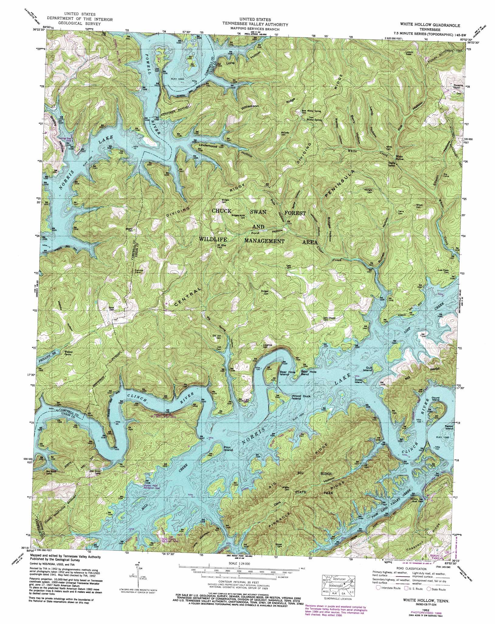
White Hollow Topo Map Tennessee
To zoom in, hover over the map of White Hollow
USGS Topo Quad 36083c8 - 1:24,000 scale
| Topo Map Name: | White Hollow |
| USGS Topo Quad ID: | 36083c8 |
| Print Size: | ca. 21 1/4" wide x 27" high |
| Southeast Coordinates: | 36.25° N latitude / 83.875° W longitude |
| Map Center Coordinates: | 36.3125° N latitude / 83.9375° W longitude |
| U.S. State: | TN |
| Filename: | o36083c8.jpg |
| Download Map JPG Image: | White Hollow topo map 1:24,000 scale |
| Map Type: | Topographic |
| Topo Series: | 7.5´ |
| Map Scale: | 1:24,000 |
| Source of Map Images: | United States Geological Survey (USGS) |
| Alternate Map Versions: |
White Hollow TN 1936 Download PDF Buy paper map White Hollow TN 1941 Download PDF Buy paper map White Hollow TN 1952, updated 1955 Download PDF Buy paper map White Hollow TN 1952, updated 1967 Download PDF Buy paper map White Hollow TN 1952, updated 1974 Download PDF Buy paper map White Hollow TN 1952, updated 1987 Download PDF Buy paper map White Hollow TN 2010 Download PDF Buy paper map White Hollow TN 2013 Download PDF Buy paper map White Hollow TN 2016 Download PDF Buy paper map |
1:24,000 Topo Quads surrounding White Hollow
Jellico West |
Jellico East |
Eagan |
Fork Ridge |
Middlesboro South |
Ivydell |
La Follette |
Well Spring |
Ausmus |
Clouds |
Jacksboro |
Demory |
White Hollow |
Maynardville |
Powder Springs |
Lake City |
Norris |
Big Ridge Park |
Graveston |
Luttrell |
Clinton |
Powell |
Fountain City |
John Sevier |
Mascot |
> Back to 36083a1 at 1:100,000 scale
> Back to 36082a1 at 1:250,000 scale
> Back to U.S. Topo Maps home
White Hollow topo map: Gazetteer
White Hollow: Bends
Bear Hole Bend elevation 317m 1040′White Hollow: Capes
Central Peninsula elevation 458m 1502′White Hollow: Crossings
Cloud Ford (historical) elevation 311m 1020′Heartyars Ferry (historical) elevation 311m 1020′
Sharps Ford (historical) elevation 311m 1020′
Swett Ford (historical) elevation 311m 1020′
White Hollow: Islands
Bear Hole Island elevation 358m 1174′Dollar Island elevation 318m 1043′
Gourd Island elevation 349m 1145′
Gull Island elevation 318m 1043′
Pilot Island elevation 318m 1043′
Wood Duck Island elevation 318m 1043′
White Hollow: Mines
Miller Quarry elevation 311m 1020′Newton Hill Quarry elevation 332m 1089′
Wilson Prospect elevation 327m 1072′
White Hollow: Parks
Chuck Swan Wildlife Management Area elevation 411m 1348′Hemlock Bluff TVA Small Wild Area elevation 394m 1292′
Loyston Point Recreation Area elevation 313m 1026′
White Hollow: Populated Places
Alder elevation 329m 1079′Forkvale (historical) elevation 340m 1115′
Girlton (historical) elevation 343m 1125′
Lost Creek (historical) elevation 329m 1079′
Loyston (historical) elevation 311m 1020′
Mossy Spring elevation 409m 1341′
Powells River (historical) elevation 323m 1059′
Ray (historical) elevation 311m 1020′
Rhodelia (historical) elevation 339m 1112′
Rule (historical) elevation 348m 1141′
Sill (historical) elevation 313m 1026′
Walnut Grove elevation 323m 1059′
White Hollow elevation 334m 1095′
White Hollow: Ridges
Bear Ridge elevation 459m 1505′Dividing elevation 458m 1502′
Pinnacle Ridge elevation 418m 1371′
Williamson Ridge elevation 427m 1400′
White Hollow: Streams
Clear Creek elevation 311m 1020′Lost Creek elevation 311m 1020′
Mill Creek elevation 311m 1020′
Poor Land Valley Creek elevation 311m 1020′
White Hollow: Summits
Weavers sKnob elevation 513m 1683′White Hollow: Valleys
Berry Hollow elevation 353m 1158′Betts Hollow elevation 354m 1161′
Big Spring Hollow elevation 311m 1020′
Brantley Hollow elevation 371m 1217′
Bridges Hollow elevation 320m 1049′
Burnett Hollow elevation 311m 1020′
Dark Hollow elevation 311m 1020′
Dark Hollow elevation 311m 1020′
Ellison Hollow elevation 320m 1049′
Graves Hollow elevation 310m 1017′
Johnson Hollow elevation 321m 1053′
Lamb Hollow elevation 342m 1122′
Lindamood Hollow elevation 311m 1020′
Long Hollow elevation 311m 1020′
Malloby Hollow elevation 324m 1062′
Pole Hollow elevation 349m 1145′
Pond Hollow elevation 349m 1145′
Roe Hollow elevation 334m 1095′
Shelby Hollow elevation 311m 1020′
White Hollow digital topo map on disk
Buy this White Hollow topo map showing relief, roads, GPS coordinates and other geographical features, as a high-resolution digital map file on DVD:
Western Virginia & Southern West Virginia
Buy digital topo maps: Western Virginia & Southern West Virginia