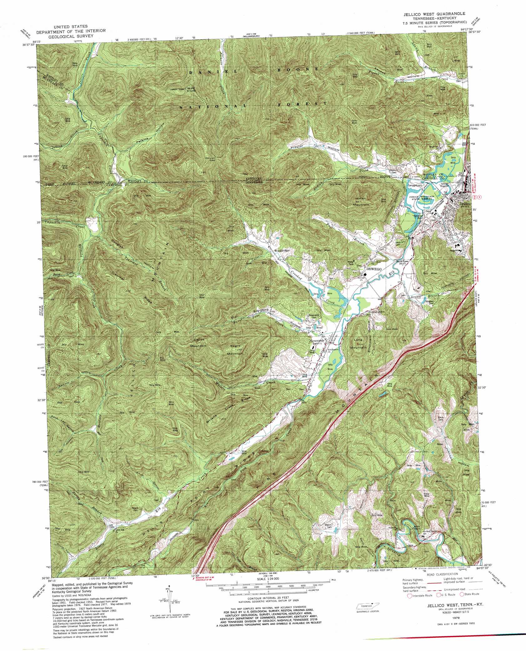
Jellico West Topo Map Tennessee
To zoom in, hover over the map of Jellico West
USGS Topo Quad 36084e2 - 1:24,000 scale
| Topo Map Name: | Jellico West |
| USGS Topo Quad ID: | 36084e2 |
| Print Size: | ca. 21 1/4" wide x 27" high |
| Southeast Coordinates: | 36.5° N latitude / 84.125° W longitude |
| Map Center Coordinates: | 36.5625° N latitude / 84.1875° W longitude |
| U.S. States: | TN, KY |
| Filename: | o36084e2.jpg |
| Download Map JPG Image: | Jellico West topo map 1:24,000 scale |
| Map Type: | Topographic |
| Topo Series: | 7.5´ |
| Map Scale: | 1:24,000 |
| Source of Map Images: | United States Geological Survey (USGS) |
| Alternate Map Versions: |
Jellico West TN 1953, updated 1954 Download PDF Buy paper map Jellico West TN 1953, updated 1959 Download PDF Buy paper map Jellico West TN 1979, updated 1980 Download PDF Buy paper map Jellico West TN 1979, updated 1980 Download PDF Buy paper map Jellico West TN 2011 Download PDF Buy paper map Jellico West TN 2013 Download PDF Buy paper map Jellico West TN 2016 Download PDF Buy paper map |
| FStopo: | US Forest Service topo Jellico West is available: Download FStopo PDF Download FStopo TIF |
1:24,000 Topo Quads surrounding Jellico West
Wiborg |
Cumberland Falls |
Wofford |
Rockholds |
Barbourville |
Whitley City |
Hollyhill |
Williamsburg |
Saxton |
Frakes |
Winfield |
Ketchen |
Jellico West |
Jellico East |
Eagan |
Huntsville |
Pioneer |
Ivydell |
La Follette |
Well Spring |
Norma |
Block |
Jacksboro |
Demory |
White Hollow |
> Back to 36084e1 at 1:100,000 scale
> Back to 36084a1 at 1:250,000 scale
> Back to U.S. Topo Maps home
Jellico West topo map: Gazetteer
Jellico West: Forests
Indian Mountain State Forest elevation 288m 944′Jellico West: Gaps
Ellison Gap elevation 575m 1886′Pit Gap elevation 585m 1919′
Jellico West: Mines
Whistle Creek Mine elevation 441m 1446′Jellico West: Parks
Indian Mountain State Park elevation 289m 948′Jellico West: Populated Places
Coal Mine (historical) elevation 324m 1062′Jellico elevation 298m 977′
Newcomb elevation 297m 974′
Oswego elevation 300m 984′
Stinking Creek elevation 373m 1223′
Wooldridge elevation 314m 1030′
Jellico West: Post Offices
Jellico Post Office elevation 298m 977′Newcomb Post Office elevation 299m 980′
Jellico West: Ridges
Hells Point Ridge elevation 484m 1587′Trammel Ridge elevation 635m 2083′
Whistle Creek Ridge elevation 575m 1886′
Jellico West: Streams
Adams Branch elevation 297m 974′Archer Branch elevation 293m 961′
Baird Creek elevation 333m 1092′
Barley Branch elevation 328m 1076′
Burnt Pone Creek elevation 297m 974′
Capuchin Creek elevation 302m 990′
Crooked Creek elevation 294m 964′
Elk Fork Creek elevation 303m 994′
Fall Branch elevation 293m 961′
Hatfield Creek elevation 318m 1043′
Indian Creek elevation 290m 951′
Indian Creek elevation 289m 948′
Jackson Creek elevation 352m 1154′
Little Elk Creek elevation 303m 994′
Perry Branch elevation 332m 1089′
Trammel Branch elevation 319m 1046′
Whistle Creek elevation 299m 980′
Jellico West: Summits
Calico Mountain elevation 640m 2099′Indian Mountain elevation 579m 1899′
Jellico Mountain elevation 689m 2260′
Long Mountain elevation 445m 1459′
Negro Mountain elevation 661m 2168′
Wolf Knob elevation 644m 2112′
Jellico West: Valleys
Brickplant Hollow elevation 297m 974′Dave Lay Hollow elevation 472m 1548′
Dock Hollow elevation 369m 1210′
Douglas Hollow elevation 319m 1046′
Hoot Owl Hollow elevation 298m 977′
Jeff Hollow elevation 358m 1174′
Joe Hollow elevation 489m 1604′
Johnson Hollow elevation 432m 1417′
Kensee Hollow elevation 299m 980′
Melvin Hollow elevation 404m 1325′
North Hollow elevation 373m 1223′
Old Standard Hollow elevation 302m 990′
Perkins Hollow elevation 310m 1017′
Proctor Hollow elevation 316m 1036′
Pruitt Hollow elevation 344m 1128′
Sawmill Hollow elevation 440m 1443′
Smith Hollow elevation 321m 1053′
Jellico West digital topo map on disk
Buy this Jellico West topo map showing relief, roads, GPS coordinates and other geographical features, as a high-resolution digital map file on DVD: