Heidelberg Topo Map Kentucky
To zoom in, hover over the map of Heidelberg
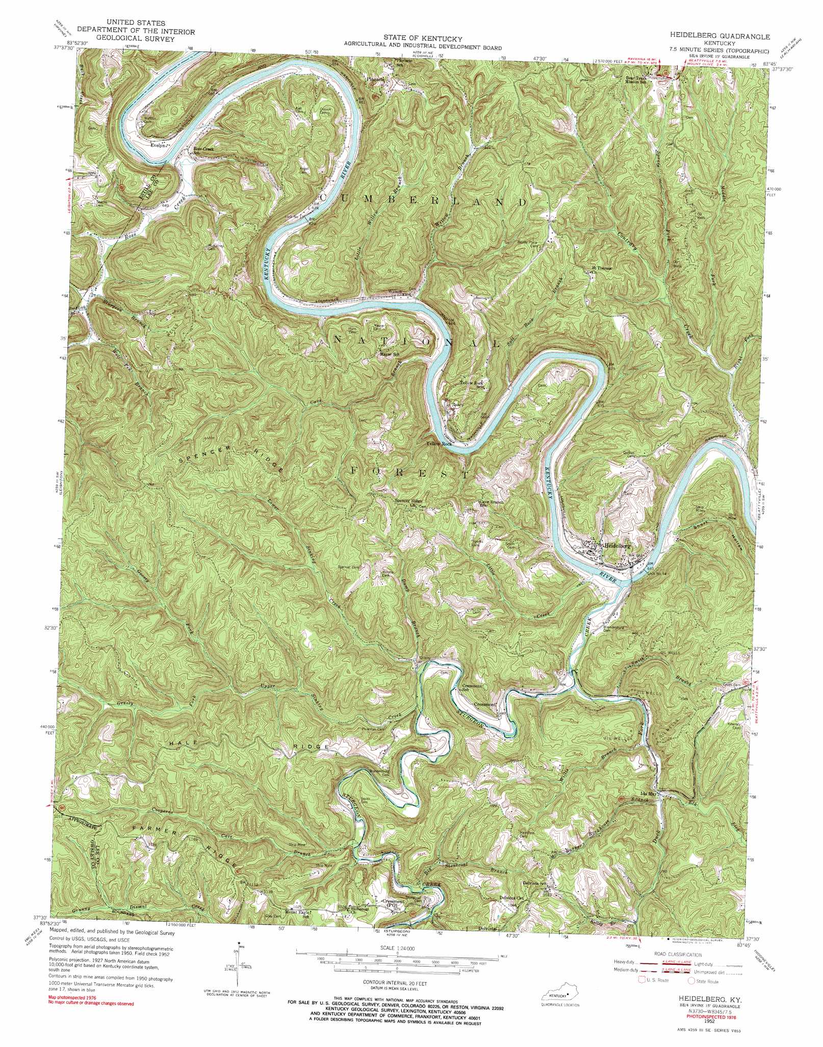
USGS Topo Quad 37083e7 - 1:24,000 scale
| Topo Map Name: | Heidelberg |
| USGS Topo Quad ID: | 37083e7 |
| Print Size: | ca. 21 1/4" wide x 27" high |
| Southeast Coordinates: | 37.5° N latitude / 83.75° W longitude |
| Map Center Coordinates: | 37.5625° N latitude / 83.8125° W longitude |
| U.S. State: | KY |
| Filename: | o37083e7.jpg |
| Download Map JPG Image: | Heidelberg topo map 1:24,000 scale |
| Map Type: | Topographic |
| Topo Series: | 7.5´ |
| Map Scale: | 1:24,000 |
| Source of Map Images: | United States Geological Survey (USGS) |
| Alternate Map Versions: |
Heidelberg KY 1952, updated 1954 Download PDF Buy paper map Heidelberg KY 1952, updated 1971 Download PDF Buy paper map Heidelberg KY 2011 Download PDF Buy paper map Heidelberg KY 2013 Download PDF Buy paper map Heidelberg KY 2016 Download PDF Buy paper map |
| FStopo: | US Forest Service topo Heidelberg is available: Download FStopo PDF Download FStopo TIF |
1:24,000 Topo Quads surrounding Heidelberg
Palmer |
Clay City |
Stanton |
Slade |
Pomeroyton |
Panola |
Irvine |
Cobhill |
Zachariah |
Campton |
Alcorn |
Leighton |
Heidelberg |
Beattyville |
Tallega |
Sandgap |
Mckee |
Sturgeon |
Booneville |
Cowcreek |
Parrot |
Tyner |
Maulden |
Oneida |
Mistletoe |
> Back to 37083e1 at 1:100,000 scale
> Back to 37082a1 at 1:250,000 scale
> Back to U.S. Topo Maps home
Heidelberg topo map: Gazetteer
Heidelberg: Dams
Lock Number 13 elevation 185m 606′Lock Number 14 elevation 198m 649′
Heidelberg: Parks
Bear Track Park elevation 361m 1184′Heidelberg: Populated Places
Cressmont elevation 208m 682′Delvinta elevation 312m 1023′
Evelyn elevation 201m 659′
Heidelberg elevation 219m 718′
Ida May elevation 215m 705′
Pinnacle elevation 279m 915′
Ross Creek (historical) elevation 195m 639′
Willow elevation 207m 679′
Yellow Rock elevation 201m 659′
Heidelberg: Post Offices
Cressmont Post Office (historical) elevation 297m 974′Evelyn Post Office (historical) elevation 198m 649′
Heidelberg: Ridges
Farmer Ridge elevation 362m 1187′Hale Ridge elevation 347m 1138′
Spencer Ridge elevation 379m 1243′
Heidelberg: Streams
Barker Rockhouse Branch elevation 216m 708′Big Stonecoal Branch elevation 216m 708′
Buck Lick Branch elevation 198m 649′
Cave Branch elevation 186m 610′
Contrary Creek elevation 194m 636′
Cooperas Cave Branch elevation 210m 688′
Duck Fork elevation 194m 636′
Dump Branch elevation 212m 695′
Elk Lick elevation 223m 731′
Elkhorn Branch elevation 217m 711′
Elkhorn Branch elevation 217m 711′
Goosey Fork elevation 239m 784′
Grassy Fork elevation 239m 784′
Kelley Branch elevation 252m 826′
Little Creek elevation 189m 620′
Little Willow Branch elevation 186m 610′
Lower Sinking Creek elevation 201m 659′
Middle Fork Contrary Creek elevation 210m 688′
Right Fork Contrary Creek elevation 203m 666′
Ross Creek elevation 186m 610′
Salt Rock Branch elevation 186m 610′
Smith Branch elevation 197m 646′
Spruce Fork elevation 268m 879′
Sturgeon Branch elevation 197m 646′
Sturgeon Creek elevation 193m 633′
Upper Sinking Creek elevation 202m 662′
Willis Branch elevation 206m 675′
Willow Branch elevation 196m 643′
Wolf Pen Branch elevation 203m 666′
Heidelberg: Valleys
Short Hollow elevation 201m 659′Heidelberg digital topo map on disk
Buy this Heidelberg topo map showing relief, roads, GPS coordinates and other geographical features, as a high-resolution digital map file on DVD:
Western Virginia & Southern West Virginia
Buy digital topo maps: Western Virginia & Southern West Virginia