Richardson Springs Nw Topo Map California
To zoom in, hover over the map of Richardson Springs Nw
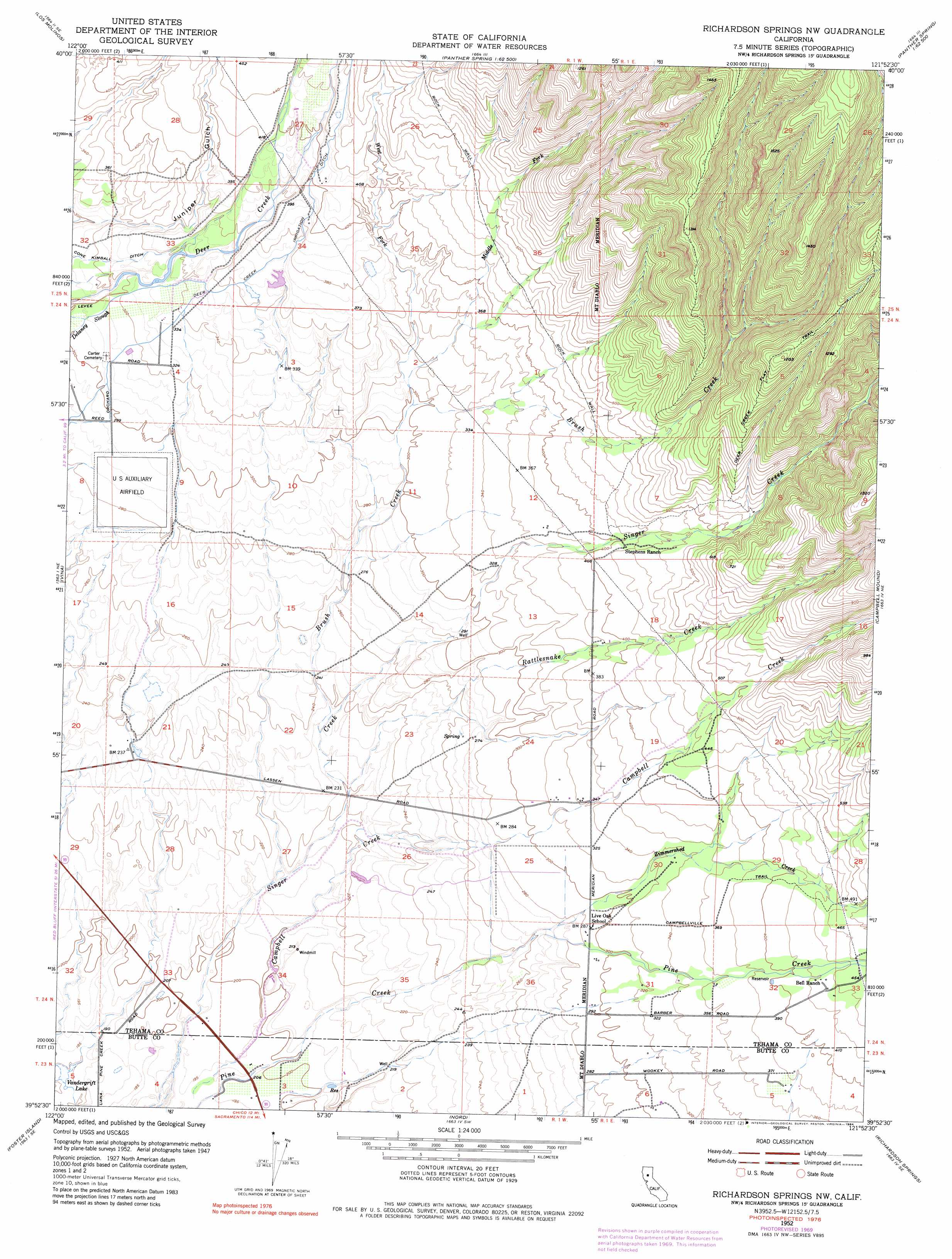
USGS Topo Quad 39121h8 - 1:24,000 scale
| Topo Map Name: | Richardson Springs Nw |
| USGS Topo Quad ID: | 39121h8 |
| Print Size: | ca. 21 1/4" wide x 27" high |
| Southeast Coordinates: | 39.875° N latitude / 121.875° W longitude |
| Map Center Coordinates: | 39.9375° N latitude / 121.9375° W longitude |
| U.S. State: | CA |
| Filename: | o39121h8.jpg |
| Download Map JPG Image: | Richardson Springs Nw topo map 1:24,000 scale |
| Map Type: | Topographic |
| Topo Series: | 7.5´ |
| Map Scale: | 1:24,000 |
| Source of Map Images: | United States Geological Survey (USGS) |
| Alternate Map Versions: |
Richardson Springs NW CA 1952, updated 1953 Download PDF Buy paper map Richardson Springs NW CA 1952, updated 1970 Download PDF Buy paper map Richardson Springs NW CA 1952, updated 1984 Download PDF Buy paper map Richardson Springs NW CA 1952, updated 1984 Download PDF Buy paper map Richardson Springs NW CA 2012 Download PDF Buy paper map Richardson Springs NW CA 2015 Download PDF Buy paper map |
1:24,000 Topo Quads surrounding Richardson Springs Nw
Red Bluff East |
Tuscan Springs |
Dewitt Peak |
Panther Spring |
Barkley Mountain |
Gerber |
Los Molinos |
Acorn Hollow |
Ishi Caves |
Devils Parade Ground |
Corning |
Vina |
Richardson Springs Nw |
Campbell Mound |
Cohasset |
Kirkwood |
Foster Island |
Nord |
Richardson Springs |
Paradise West |
Orland |
Hamilton City |
Ord Ferry |
Chico |
Hamlin Canyon |
> Back to 39121e1 at 1:100,000 scale
> Back to 39120a1 at 1:250,000 scale
> Back to U.S. Topo Maps home
Richardson Springs Nw topo map: Gazetteer
Richardson Springs Nw: Airports
Deer Creek Ranch Airport elevation 87m 285′Richardson Springs Nw: Canals
Cone Kimball Ditch elevation 100m 328′Deer Creek Irrigation Ditch elevation 114m 374′
Richardson Springs Nw: Lakes
Vandergrift Lake elevation 55m 180′Richardson Springs Nw: Streams
Brush Creek elevation 71m 232′Campbell Creek elevation 60m 196′
Middle Fork Brush Creek elevation 92m 301′
Rattlesnake Creek elevation 68m 223′
West Fork Brush Creek elevation 92m 301′
Zimmershed Creek elevation 80m 262′
Richardson Springs Nw: Trails
Deer Creek Flat Trail elevation 310m 1017′Richardson Springs Nw: Valleys
Juniper Gulch elevation 95m 311′Richardson Springs Nw digital topo map on disk
Buy this Richardson Springs Nw topo map showing relief, roads, GPS coordinates and other geographical features, as a high-resolution digital map file on DVD: