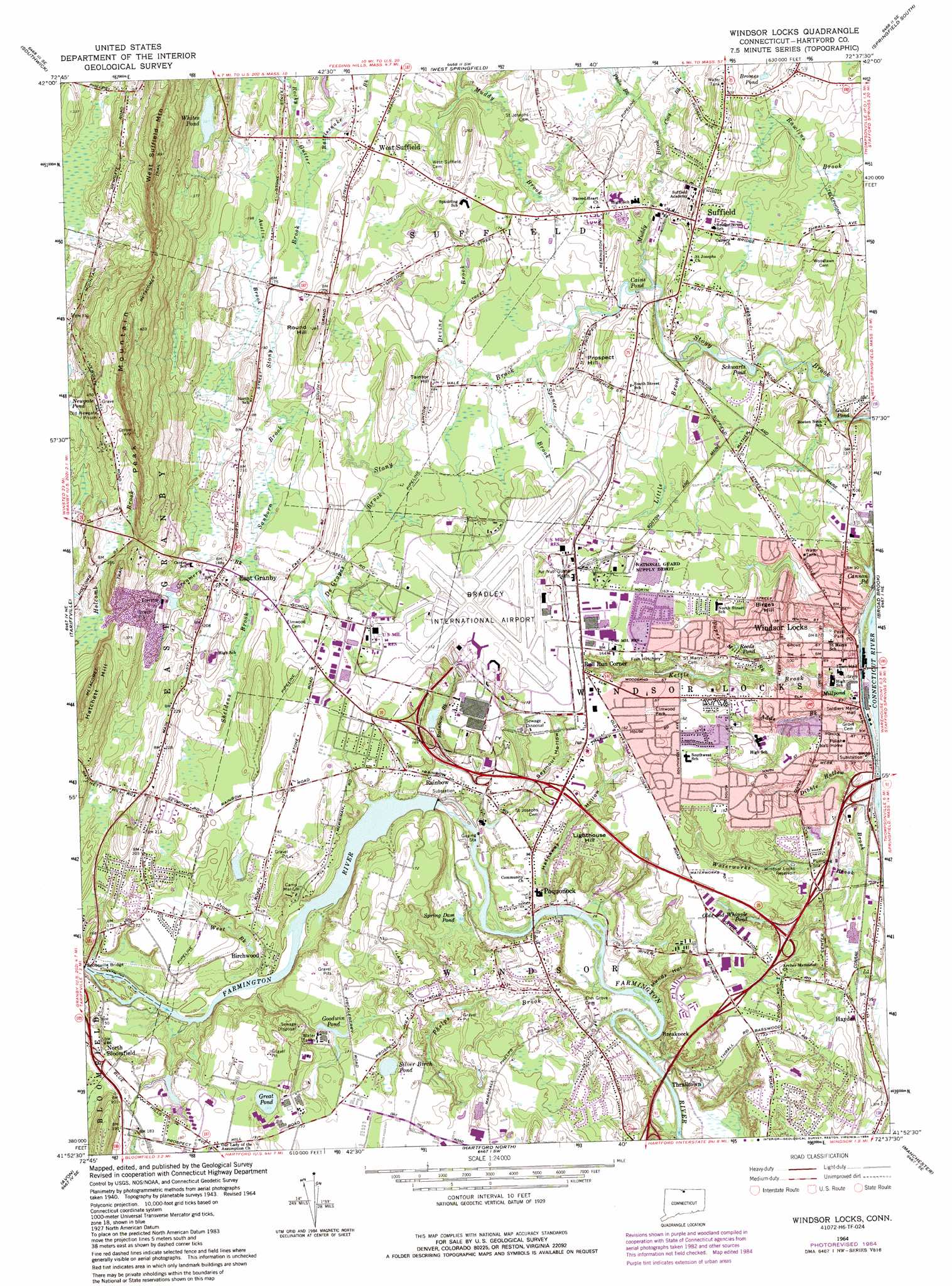
Windsor Locks Topo Map Connecticut
To zoom in, hover over the map of Windsor Locks
USGS Topo Quad 41072h6 - 1:24,000 scale
| Topo Map Name: | Windsor Locks |
| USGS Topo Quad ID: | 41072h6 |
| Print Size: | ca. 21 1/4" wide x 27" high |
| Southeast Coordinates: | 41.875° N latitude / 72.625° W longitude |
| Map Center Coordinates: | 41.9375° N latitude / 72.6875° W longitude |
| U.S. State: | CT |
| Filename: | o41072h6.jpg |
| Download Map JPG Image: | Windsor Locks topo map 1:24,000 scale |
| Map Type: | Topographic |
| Topo Series: | 7.5´ |
| Map Scale: | 1:24,000 |
| Source of Map Images: | United States Geological Survey (USGS) |
| Alternate Map Versions: |
Windsor Locks CT 1928 Download PDF Buy paper map Windsor Locks CT 1953, updated 1959 Download PDF Buy paper map Windsor Locks CT 1964, updated 1966 Download PDF Buy paper map Windsor Locks CT 1964, updated 1973 Download PDF Buy paper map Windsor Locks CT 1964, updated 1984 Download PDF Buy paper map Windsor Locks CT 2012 Download PDF Buy paper map Windsor Locks CT 2015 Download PDF Buy paper map |
1:24,000 Topo Quads surrounding Windsor Locks
Woronoco |
Mount Tom |
Springfield North |
Ludlow |
|
Southwick |
West Springfield |
Springfield South |
Hampden |
|
New Hartford |
Tariffville |
Windsor Locks |
Broad Brook |
Ellington |
Collinsville |
Avon |
Hartford North |
Manchester |
Rockville |
Bristol |
New Britain |
Hartford South |
Glastonbury |
Marlborough |
> Back to 41072e1 at 1:100,000 scale
> Back to 41072a1 at 1:250,000 scale
> Back to U.S. Topo Maps home
Windsor Locks topo map: Gazetteer
Windsor Locks: Airports
Bradley International Airport elevation 57m 187′Hamilton Standard Heliport elevation 55m 180′
Marks Heliport elevation 51m 167′
Windsor Locks: Bridges
Spoonville Bridge elevation 32m 104′Windsor Locks: Dams
Bungee Lake Lower Dam elevation 52m 170′Rainbow Dam elevation 24m 78′
Rainbow Pond Dam elevation 12m 39′
Schwartz Pond Dam elevation 40m 131′
Whites Pond Dam elevation 100m 328′
Windsor Locks: Lakes
Bromes Pond elevation 48m 157′Cannon Pond elevation 22m 72′
Goodwin Pond elevation 74m 242′
Great Pond elevation 52m 170′
Newgate Pond elevation 96m 314′
Olds and Whipple Pond elevation 38m 124′
Reeds Pond elevation 41m 134′
Schwartz Pond elevation 40m 131′
Silver Birch Pond elevation 48m 157′
Spring Dam Pond elevation 21m 68′
Whites Pond elevation 100m 328′
Windsor Locks: Parks
Brazin Bruce Park elevation 44m 144′Christian Field elevation 48m 157′
East Granby Historic District elevation 61m 200′
John R Welch Park elevation 23m 75′
Lewis Farm Bird Sanctuary elevation 53m 173′
Noden-Reed Park elevation 38m 124′
Northwest Park elevation 61m 200′
Peski Park elevation 31m 101′
Rainbow Park elevation 41m 134′
Southwest Park elevation 54m 177′
Spring Park elevation 48m 157′
Stony Brook Park elevation 37m 121′
Suffield Historic District elevation 58m 190′
Windsor Locks: Populated Places
Birchwood elevation 43m 141′Breakneck elevation 30m 98′
Bull Run Corner elevation 54m 177′
East Granby elevation 63m 206′
Green Manor Village elevation 57m 187′
Hayden elevation 17m 55′
Higley Village elevation 64m 209′
North Bloomfield elevation 62m 203′
Poquonock elevation 32m 104′
Rainbow elevation 31m 101′
Spoonville elevation 34m 111′
Spoonville (historical) elevation 31m 101′
Suffield elevation 56m 183′
Suffield Depot elevation 55m 180′
Thralltown elevation 29m 95′
West Suffield elevation 60m 196′
Windsor Locks elevation 15m 49′
Windsor Locks: Post Offices
Poquonock Post Office elevation 29m 95′West Suffield Post Office elevation 63m 206′
Windsor Locks Post Office elevation 20m 65′
Windsor Locks: Reservoirs
Bungee Lake elevation 52m 170′Cains Pond elevation 44m 144′
Rainbow Pond elevation 12m 39′
Windsor Locks Reservoir elevation 32m 104′
Windsor Locks: Streams
Adds Brook elevation 19m 62′Austin Brook elevation 54m 177′
Clay Brook elevation 42m 137′
Creamery Brook elevation 56m 183′
DeGrayes Brook elevation 47m 154′
Devine Brook elevation 43m 141′
Dibble Hollow Brook elevation 11m 36′
Kettle Brook elevation 11m 36′
Little Brook elevation 37m 121′
Muddy Brook elevation 40m 131′
Paper Mill Brook elevation 27m 88′
Phelps Brook elevation 4m 13′
Philo Brook elevation 42m 137′
Philo Brook elevation 42m 137′
Rainbow Brook elevation 14m 45′
Rattlesnake Brook elevation 57m 187′
Rocky Gutter elevation 56m 183′
Sanborn Brook elevation 60m 196′
Sheldens Brook elevation 53m 173′
Spencer Brook elevation 42m 137′
Strawberry Meadow Brook elevation 16m 52′
West Brook elevation 33m 108′
Windsor Locks: Summits
Barrett Hill elevation 40m 131′Birges Hill elevation 49m 160′
Hatchett Hill elevation 134m 439′
Lighthouse Hill elevation 51m 167′
Meeting House Hill elevation 62m 203′
Peak Mountain elevation 177m 580′
Prospect Hill elevation 60m 196′
Round Hill elevation 74m 242′
Sherman Hill elevation 42m 137′
Taintor Hill elevation 52m 170′
Windsor Locks: Swamps
Dismal Swamp elevation 55m 180′Halfmoon Marsh elevation 62m 203′
Windsor Locks: Valleys
Hathaway Hollow elevation 16m 52′Mundy Hollow elevation 15m 49′
Seymour Hollow elevation 40m 131′
Windsor Locks digital topo map on disk
Buy this Windsor Locks topo map showing relief, roads, GPS coordinates and other geographical features, as a high-resolution digital map file on DVD:
New York, Vermont, Connecticut & Western Massachusetts
Buy digital topo maps: New York, Vermont, Connecticut & Western Massachusetts