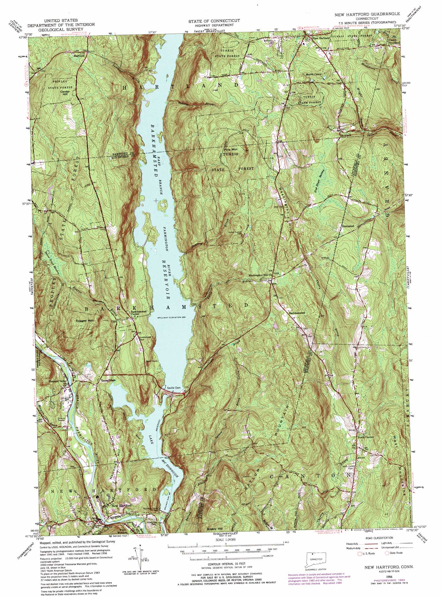
New Hartford Topo Map Connecticut
To zoom in, hover over the map of New Hartford
USGS Topo Quad 41072h8 - 1:24,000 scale
| Topo Map Name: | New Hartford |
| USGS Topo Quad ID: | 41072h8 |
| Print Size: | ca. 21 1/4" wide x 27" high |
| Southeast Coordinates: | 41.875° N latitude / 72.875° W longitude |
| Map Center Coordinates: | 41.9375° N latitude / 72.9375° W longitude |
| U.S. State: | CT |
| Filename: | o41072h8.jpg |
| Download Map JPG Image: | New Hartford topo map 1:24,000 scale |
| Map Type: | Topographic |
| Topo Series: | 7.5´ |
| Map Scale: | 1:24,000 |
| Source of Map Images: | United States Geological Survey (USGS) |
| Alternate Map Versions: |
New Hartford CT 1956, updated 1959 Download PDF Buy paper map New Hartford CT 1956, updated 1965 Download PDF Buy paper map New Hartford CT 1956, updated 1969 Download PDF Buy paper map New Hartford CT 1956, updated 1972 Download PDF Buy paper map New Hartford CT 1956, updated 1984 Download PDF Buy paper map New Hartford CT 1956, updated 1984 Download PDF Buy paper map New Hartford CT 2012 Download PDF Buy paper map New Hartford CT 2015 Download PDF Buy paper map |
1:24,000 Topo Quads surrounding New Hartford
Otis |
Woronoco |
Mount Tom |
||
Tolland Center |
Southwick |
West Springfield |
||
Norfolk |
Winsted |
New Hartford |
Tariffville |
Windsor Locks |
West Torrington |
Torrington |
Collinsville |
Avon |
Hartford North |
Litchfield |
Thomaston |
Bristol |
New Britain |
Hartford South |
> Back to 41072e1 at 1:100,000 scale
> Back to 41072a1 at 1:250,000 scale
> Back to U.S. Topo Maps home
New Hartford topo map: Gazetteer
New Hartford: Bridges
Gilbert Bridge elevation 126m 413′New Hartford: Dams
Richards Corner Dam elevation 128m 419′Saville Dam elevation 141m 462′
New Hartford: Forests
J O Enders State Forest elevation 277m 908′Peoples State Forest elevation 261m 856′
New Hartford: Parks
Callahan Park elevation 117m 383′New Hartford: Populated Places
Barkhampsted Center elevation 194m 636′Barkhamsted elevation 329m 1079′
East Hartland elevation 366m 1200′
Hampsted elevation 311m 1020′
Hartland elevation 342m 1122′
New Hartford elevation 137m 449′
North Canton elevation 201m 659′
Pine Meadow elevation 114m 374′
Pleasant Valley elevation 125m 410′
New Hartford: Post Offices
East Hartland Post Office elevation 362m 1187′New Hartford Post Office elevation 132m 433′
North Canton Post Office elevation 204m 669′
Pleasant Valley Post Office elevation 125m 410′
New Hartford: Reservoirs
Barkhamsted Reservoir elevation 136m 446′Compensating Reservoir elevation 121m 396′
Lake Mc Donough elevation 128m 419′
New Hartford: Streams
Beaver Brook elevation 129m 423′East Mountain Brook elevation 122m 400′
Hallock Brook elevation 112m 367′
Kettle Brook elevation 167m 547′
Morgan Brook elevation 125m 410′
Roaring Brook elevation 174m 570′
Roberts Brook elevation 173m 567′
Sawmill Brook elevation 163m 534′
Spruce Brook elevation 199m 652′
Storehouse Brook elevation 136m 446′
Wright Brook elevation 248m 813′
New Hartford: Summits
Center Hill elevation 393m 1289′Holcomb Hill elevation 211m 692′
Pine Mountain elevation 421m 1381′
Ragged Mountain elevation 311m 1020′
Ratlum Mountain elevation 358m 1174′
Washington Hill elevation 359m 1177′
New Hartford: Swamps
Beaver Brook Meadow elevation 231m 757′Hoyt Hayes Swamp elevation 276m 905′
New Hartford digital topo map on disk
Buy this New Hartford topo map showing relief, roads, GPS coordinates and other geographical features, as a high-resolution digital map file on DVD:
New York, Vermont, Connecticut & Western Massachusetts
Buy digital topo maps: New York, Vermont, Connecticut & Western Massachusetts