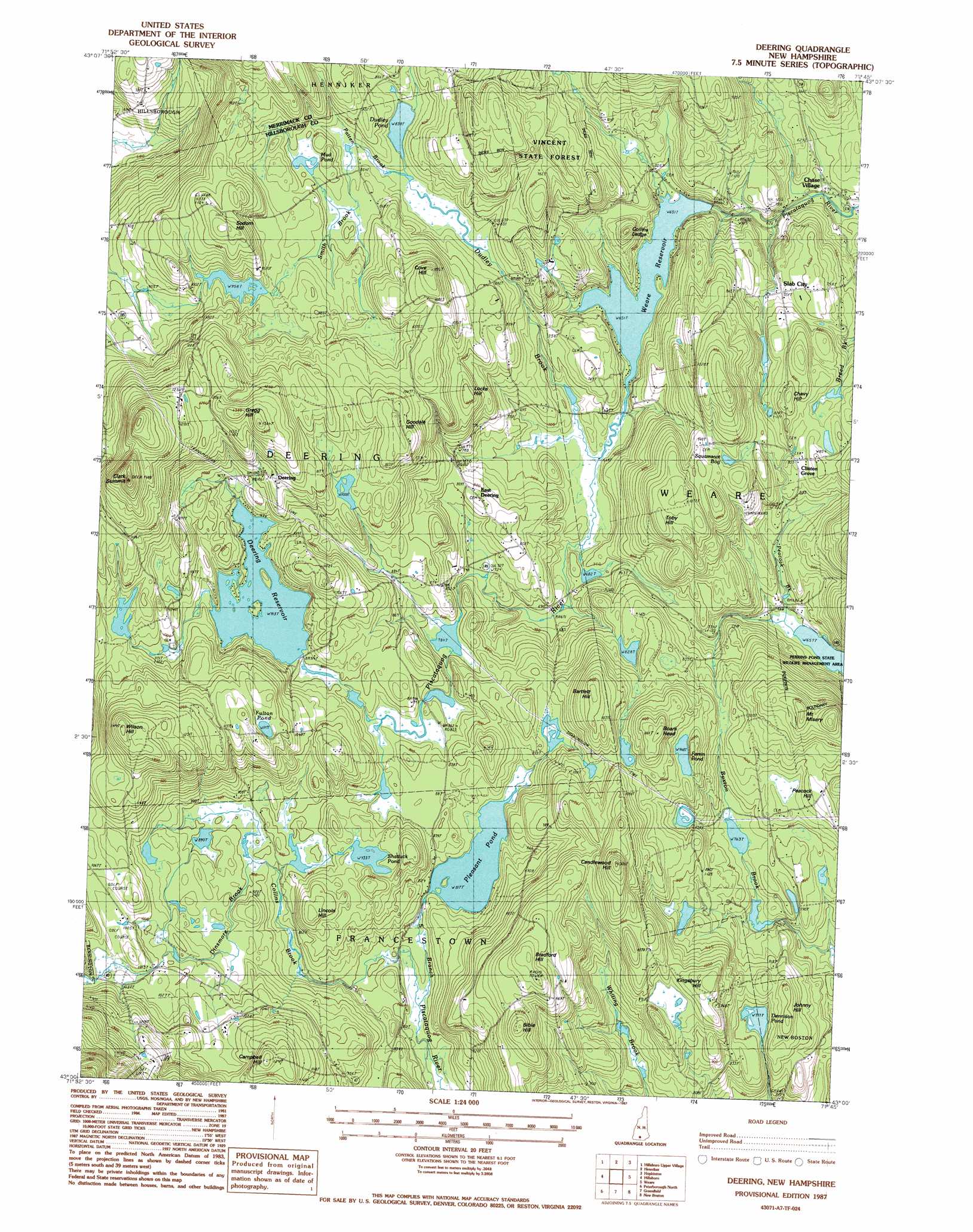
Deering Topo Map New Hampshire
To zoom in, hover over the map of Deering
USGS Topo Quad 43071a7 - 1:24,000 scale
| Topo Map Name: | Deering |
| USGS Topo Quad ID: | 43071a7 |
| Print Size: | ca. 21 1/4" wide x 27" high |
| Southeast Coordinates: | 43° N latitude / 71.75° W longitude |
| Map Center Coordinates: | 43.0625° N latitude / 71.8125° W longitude |
| U.S. State: | NH |
| Filename: | o43071a7.jpg |
| Download Map JPG Image: | Deering topo map 1:24,000 scale |
| Map Type: | Topographic |
| Topo Series: | 7.5´ |
| Map Scale: | 1:24,000 |
| Source of Map Images: | United States Geological Survey (USGS) |
| Alternate Map Versions: |
Deering NH 1987, updated 1987 Download PDF Buy paper map Deering NH 1998, updated 2001 Download PDF Buy paper map Deering NH 2012 Download PDF Buy paper map Deering NH 2015 Download PDF Buy paper map |
1:24,000 Topo Quads surrounding Deering
Sunapee Lakes |
Bradford |
Warner |
Webster |
Penacook |
Washington |
Hillsboro Upper Village |
Henniker |
Hopkinton |
Concord |
Stoddard |
Hillsboro |
Deering |
Weare |
Goffstown |
Dublin |
Peterborough North |
Greenfield |
New Boston |
Pinardville |
Monadnock Mountain |
Peterborough South |
Greenville |
Milford |
South Merrimack |
> Back to 43071a1 at 1:100,000 scale
> Back to 43070a1 at 1:250,000 scale
> Back to U.S. Topo Maps home
Deering topo map: Gazetteer
Deering: Dams
Deering Reservoir Dam elevation 275m 902′Dudley Pond Dam elevation 255m 836′
Pleasant Pond Dam elevation 255m 836′
Weare Reservoir Dam elevation 194m 636′
Deering: Forests
Vincent State Forest elevation 356m 1167′Deering: Lakes
Dennison Pond elevation 236m 774′Ferrut Pond elevation 288m 944′
Fulton Pond elevation 340m 1115′
Mud Pond elevation 274m 898′
Shattuck Pond elevation 285m 935′
Deering: Parks
Deering Reserve elevation 330m 1082′Perkins Pond State Wildlife Management Area elevation 199m 652′
Deering: Populated Places
Chase Village elevation 177m 580′Clinton Grove elevation 257m 843′
Deering elevation 329m 1079′
East Deering elevation 249m 816′
Slab City elevation 234m 767′
Deering: Reservoirs
Deering Reservoir elevation 275m 902′Dudley Pond elevation 255m 836′
Ferrin Pond elevation 288m 944′
Pleasant Pond elevation 255m 836′
Weare Reservoir elevation 194m 636′
Deering: Streams
Collins Brook elevation 234m 767′Dinsmore Brook elevation 270m 885′
Dudley Brook elevation 200m 656′
Patten Brook elevation 255m 836′
Smith Brook elevation 258m 846′
Deering: Summits
Bartlett Hill elevation 332m 1089′Bible Hill elevation 389m 1276′
Boars Head elevation 348m 1141′
Bradford Hill elevation 379m 1243′
Campbell Hill elevation 393m 1289′
Candlewood Hill elevation 396m 1299′
Chevy Hill elevation 359m 1177′
Clark Summit elevation 464m 1522′
Collins Ledge elevation 277m 908′
Cove Hill elevation 362m 1187′
Goodale Hill elevation 347m 1138′
Gregg Hill elevation 397m 1302′
Johnny Hill elevation 277m 908′
Kingsbury Hill elevation 319m 1046′
Lincoln Hill elevation 320m 1049′
Locke Hill elevation 301m 987′
Mount Misery elevation 350m 1148′
Peacock Hill elevation 283m 928′
Sodom Hill elevation 359m 1177′
Toby Hill elevation 323m 1059′
Wilson Hill elevation 429m 1407′
Deering: Swamps
Squamscot Bog elevation 280m 918′Deering digital topo map on disk
Buy this Deering topo map showing relief, roads, GPS coordinates and other geographical features, as a high-resolution digital map file on DVD:
Maine, New Hampshire, Rhode Island & Eastern Massachusetts
Buy digital topo maps: Maine, New Hampshire, Rhode Island & Eastern Massachusetts