Tolland Center Topo Map Massachusetts
To zoom in, hover over the map of Tolland Center
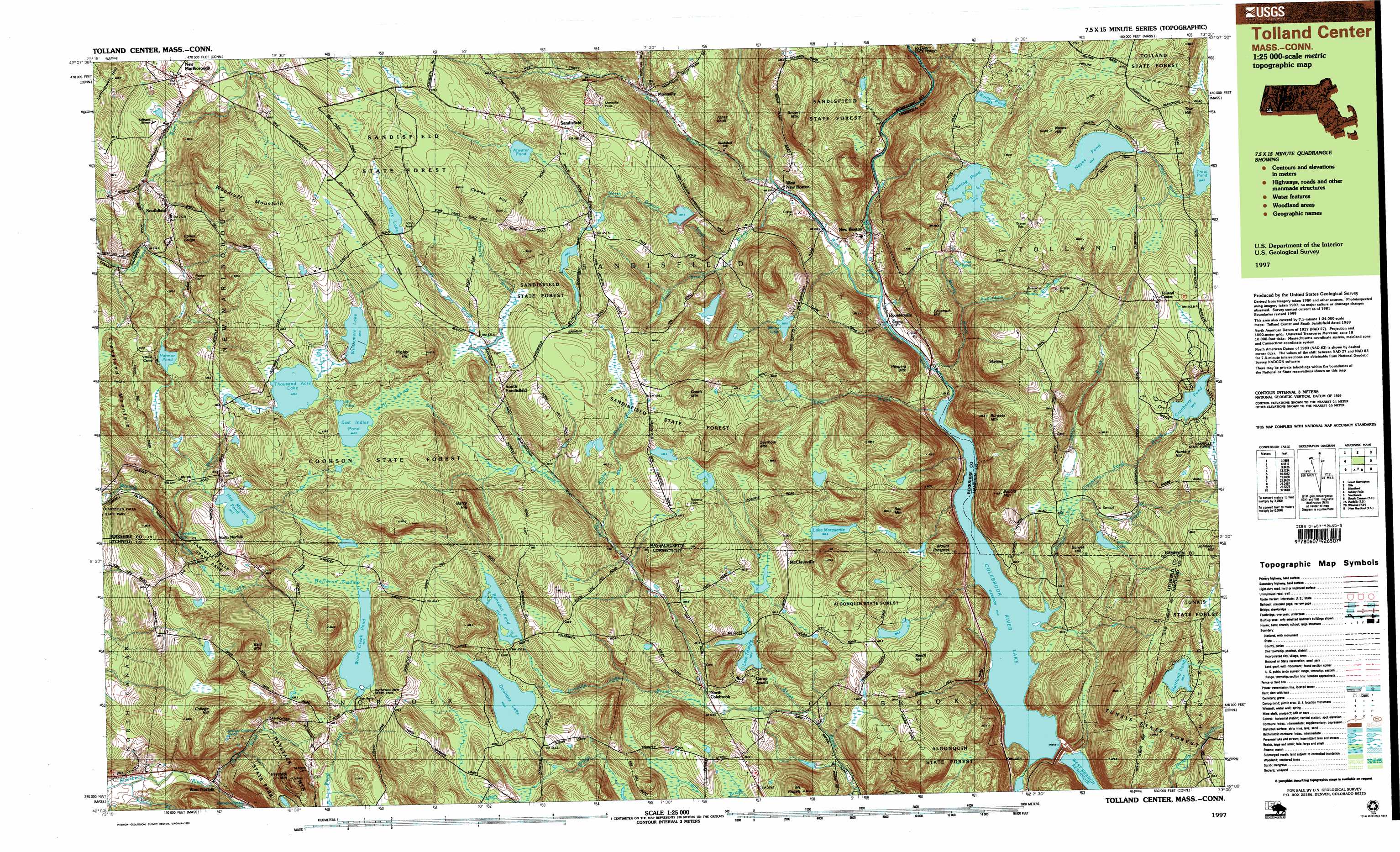
USGS Topo Quad 42073a1 - 1:25,000 scale
| Topo Map Name: | Tolland Center |
| USGS Topo Quad ID: | 42073a1 |
| Print Size: | ca. 39" wide x 24" high |
| Southeast Coordinates: | 42° N latitude / 73° W longitude |
| Map Center Coordinates: | 42.0625° N latitude / 73.125° W longitude |
| U.S. States: | MA, CT |
| Filename: | k42073a1.jpg |
| Download Map JPG Image: | Tolland Center topo map 1:25,000 scale |
| Map Type: | Topographic |
| Topo Series: | 7.5´x15´ |
| Map Scale: | 1:25,000 |
| Source of Map Images: | United States Geological Survey (USGS) |
| Alternate Map Versions: |
Tolland Center MA 1987, updated 1987 Download PDF Buy paper map Tolland Center MA 1997, updated 1999 Download PDF Buy paper map |
1:24,000 Topo Quads surrounding Tolland Center
Stockbridge |
Becket |
Westhampton |
||
Great Barrington |
Otis |
Woronoco |
||
Ashley Falls |
Tolland Center |
Southwick |
||
South Canaan |
Norfolk |
Winsted |
New Hartford |
Tariffville |
Cornwall |
West Torrington |
Torrington |
Collinsville |
Avon |
> Back to 42073a1 at 1:100,000 scale
> Back to 42072a1 at 1:250,000 scale
> Back to U.S. Topo Maps home
Tolland Center topo map: Gazetteer
Tolland Center: Dams
Atwater Pond Dam elevation 472m 1548′Benedict Pond Dam elevation 412m 1351′
Clam River Watershed Dam elevation 368m 1207′
Colebrook River Dam elevation 238m 780′
Cookson Dam elevation 360m 1181′
Cranberry Pond Dam elevation 399m 1309′
Doolittle Lake Dam elevation 424m 1391′
Lake Triangle Dam elevation 346m 1135′
Lemanquais Pond Dam elevation 398m 1305′
Lost Wilderness Lake Northern Dam elevation 412m 1351′
Lost Wilderness Lake Southern Dam elevation 412m 1351′
Mirror Lake Dam elevation 367m 1204′
North Silver Lake Dam elevation 391m 1282′
Noyes Pond Dam elevation 438m 1437′
Pelton Dam elevation 448m 1469′
Riiska Brook Dam elevation 439m 1440′
Thousand Acre Site Number 1 Dam elevation 427m 1400′
Victory Lake Dam elevation 308m 1010′
Wards Pond Dam elevation 408m 1338′
Windemere Lake Dam elevation 432m 1417′
Woodcreek Dike elevation 410m 1345′
Woodcreek Pond Dam elevation 418m 1371′
York Lake Dam elevation 467m 1532′
Tolland Center: Falls
Campbell Falls elevation 310m 1017′Tolland Center: Forests
Cookson State Forest elevation 477m 1564′Sandisfield State Forest elevation 510m 1673′
Tolland Center: Lakes
Benedict Pond elevation 412m 1351′Doolittle Lake elevation 424m 1391′
East Indies Pond elevation 444m 1456′
Harmon Pond elevation 386m 1266′
Hartland Pond elevation 352m 1154′
Lake Marguerite elevation 357m 1171′
Mill Pond elevation 441m 1446′
Mirror Lake elevation 375m 1230′
Trout Pond elevation 420m 1377′
Twining Pond elevation 408m 1338′
Wood Creek Pond elevation 418m 1371′
Tolland Center: Parks
Campbell Falls State Park elevation 355m 1164′Haystack Mountain State Park elevation 443m 1453′
North Green elevation 465m 1525′
Tolland Center: Populated Places
Camp Spruce Hill elevation 309m 1013′Konkapot elevation 435m 1427′
McClaveville elevation 391m 1282′
Montville elevation 359m 1177′
New Boston elevation 260m 853′
New Marlborough elevation 414m 1358′
North Colebrook elevation 332m 1089′
Roosterville elevation 232m 761′
Sandisfield elevation 476m 1561′
Skyland elevation 476m 1561′
South Sandisfield elevation 434m 1423′
Southfield elevation 371m 1217′
Tolland Center elevation 463m 1519′
West New Boston elevation 271m 889′
West Norfolk elevation 276m 905′
Tolland Center: Post Offices
Sandisfield Post Office elevation 288m 944′Southfield Post Office elevation 367m 1204′
West New Boston Post Office elevation 286m 938′
Tolland Center: Reservoirs
Atwater Pond elevation 472m 1548′Clam River Watershed Reservoir elevation 368m 1207′
Colebrook River Lake elevation 238m 780′
Cranberry Pond elevation 399m 1309′
Lake Triangle elevation 346m 1135′
Lemanquais Pond elevation 398m 1305′
Lost Wilderness Lake elevation 412m 1351′
North Silver Lake Reservoir elevation 391m 1282′
Noyes Pond elevation 438m 1437′
Pelton Reservoir elevation 448m 1469′
Thousand Acre Swamp Reservoir elevation 427m 1400′
Victory Lake elevation 303m 994′
Wards Pond elevation 408m 1338′
Windemere Lake Reservoir elevation 432m 1417′
Wood Creek Reservoir elevation 410m 1345′
York Lake elevation 467m 1532′
Tolland Center: Streams
Buck River elevation 270m 885′Center Brook elevation 277m 908′
Cherry Brook elevation 433m 1420′
Clam River elevation 242m 793′
Cranberry Pond Brook elevation 277m 908′
Doolittle Lake Brook elevation 334m 1095′
Ginger Creek elevation 297m 974′
Ginger Creek elevation 297m 974′
Haley Brook elevation 329m 1079′
Howells Brook elevation 261m 856′
Moody Brook elevation 230m 754′
North Branch Silver Brook elevation 349m 1145′
North Brook elevation 309m 1013′
North Brook elevation 265m 869′
Richardson Brook elevation 359m 1177′
Riiska Brook elevation 393m 1289′
Roaring Brook elevation 242m 793′
Silver Brook elevation 269m 882′
Slocum Brook elevation 214m 702′
South Branch Silver Brook elevation 349m 1145′
Taylor Brook elevation 279m 915′
Thorp Brook elevation 216m 708′
Tolland Center: Summits
Babbitt Mountain elevation 407m 1335′Bald Mountain elevation 539m 1768′
Barry Hill elevation 497m 1630′
Beech Hill elevation 429m 1407′
Beecher Hill elevation 430m 1410′
Brown Mountain elevation 499m 1637′
Bull Mountain elevation 456m 1496′
Burgess Mountain elevation 438m 1437′
Chestnut Hill elevation 423m 1387′
Cleveland Mountain elevation 442m 1450′
College Hill elevation 466m 1528′
Cooks Ledge elevation 402m 1318′
Cowles Hill elevation 537m 1761′
Dodds Mountain elevation 516m 1692′
East Bald Mountain elevation 519m 1702′
Hanging Mountain elevation 360m 1181′
Haystack Mountain elevation 510m 1673′
Higley Hill elevation 519m 1702′
Hunting Hill elevation 432m 1417′
Jones Knoll elevation 399m 1309′
Leffingwell Hill elevation 446m 1463′
Mount Pisgah elevation 422m 1384′
Mount Prospect elevation 386m 1266′
Mount Prospect elevation 382m 1253′
Noyes Hill elevation 496m 1627′
Seymour Mountain elevation 517m 1696′
Snow Mountain elevation 462m 1515′
Sunset Hill elevation 338m 1108′
Tow Hill elevation 466m 1528′
Woodruff Mountain elevation 499m 1637′
Tolland Center: Swamps
Holleran Swamp elevation 419m 1374′Thousand Acre Swamp elevation 424m 1391′
Wolf Swamp elevation 438m 1437′
Tolland Center digital topo map on disk
Buy this Tolland Center topo map showing relief, roads, GPS coordinates and other geographical features, as a high-resolution digital map file on DVD:
New York, Vermont, Connecticut & Western Massachusetts
Buy digital topo maps: New York, Vermont, Connecticut & Western Massachusetts