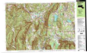
Stockbridge Topo Map Massachusetts
To zoom in, hover over the map of Stockbridge
USGS Topo Quad 42073c3 - 1:25,000 scale
| Topo Map Name: | Stockbridge |
| USGS Topo Quad ID: | 42073c3 |
| Print Size: | ca. 39" wide x 24" high |
| Southeast Coordinates: | 42.25° N latitude / 73.25° W longitude |
| Map Center Coordinates: | 42.3125° N latitude / 73.375° W longitude |
| U.S. State: | MA |
| Filename: | k42073c3.jpg |
| Download Map JPG Image: | Stockbridge topo map 1:25,000 scale |
| Map Type: | Topographic |
| Topo Series: | 7.5´x15´ |
| Map Scale: | 1:25,000 |
| Source of Map Images: | United States Geological Survey (USGS) |
| Alternate Map Versions: |
Stockbridge MA 1987, updated 1987 Download PDF Buy paper map Stockbridge MA 1987, updated 1987 Download PDF Buy paper map Stockbridge MA 1997, updated 1999 Download PDF Buy paper map |
1:24,000 Topo Quads surrounding Stockbridge
Nassau |
Hancock |
Windsor |
||
East Chatham |
Pittsfield West |
Peru |
||
Chatham |
Stockbridge |
Becket |
||
Hillsdale |
Great Barrington |
Otis |
||
Copake |
Ashley Falls |
Tolland Center |
> Back to 42073a1 at 1:100,000 scale
> Back to 42072a1 at 1:250,000 scale
> Back to U.S. Topo Maps home
Stockbridge topo map: Gazetteer
Stockbridge: Crossings
Interchange One elevation 288m 944′Stockbridge: Dams
Card Pond Dam elevation 283m 928′Glendale Dam elevation 275m 902′
Lake Averic Dam elevation 274m 898′
Laurel Lake Dam elevation 316m 1036′
Round Pond Dam elevation 283m 928′
Shaker Mill Pond Dam elevation 272m 892′
Stockbridge Bowl Dam elevation 281m 921′
Willow Mill - Hurlbut Dam elevation 264m 866′
Stockbridge: Forests
Beebe Hill State Forest elevation 442m 1450′Stockbridge: Gaps
Burgoyne Pass elevation 478m 1568′Stockbridge: Lakes
Agawam Lake elevation 253m 830′Barrett Pond elevation 433m 1420′
Card Pond elevation 280m 918′
Clark Pond elevation 250m 820′
Cranberry Pond elevation 274m 898′
Crane Lake elevation 273m 895′
Crystal Lake elevation 344m 1128′
Fairfield Pond elevation 352m 1154′
Harts Pond elevation 226m 741′
Hatch Pond elevation 244m 800′
Hudson Ore Bed Pond elevation 280m 918′
Lake Averic elevation 276m 905′
Leet Ore Bed Pond elevation 289m 948′
Lily Pond elevation 295m 967′
Mohawk Lake elevation 285m 935′
Mud Ponds elevation 272m 892′
No Bottom Pond elevation 481m 1578′
Perkins Pond elevation 308m 1010′
Stockbridge: Parks
Berkshire Botanical Gardens elevation 254m 833′Berkshire Gardens Center elevation 269m 882′
Berkshire Market Village elevation 276m 905′
Field Arboretum elevation 283m 928′
Kennedy Park elevation 449m 1473′
Oak n' Spruce Village elevation 265m 869′
Schermerhorn Park elevation 360m 1181′
Stockbridge: Populated Places
Austerlitz elevation 344m 1128′Beachwood elevation 283m 928′
Camp Kingsmont elevation 346m 1135′
Camp Mah-Kee-Nac elevation 293m 961′
Carey Corner elevation 350m 1148′
Crane Lake Camp elevation 301m 987′
Eastover elevation 346m 1135′
Glendale elevation 260m 853′
Green River elevation 289m 948′
Housatonic elevation 224m 734′
Interlaken elevation 271m 889′
Larrywaug elevation 262m 859′
Lenox elevation 383m 1256′
Mahkeenac Heights elevation 335m 1099′
Mahkeenac Shores elevation 296m 971′
Mahkeenac Terrace elevation 293m 961′
Richmond elevation 325m 1066′
Richmond Furnace elevation 304m 997′
Rockdale Mills elevation 268m 879′
South Lee elevation 260m 853′
State Line elevation 284m 931′
Stockbridge elevation 252m 826′
Tanglewood elevation 333m 1092′
West Stockbridge elevation 284m 931′
West Stockbridge Center elevation 361m 1184′
Wheatleigh elevation 309m 1013′
Williamsville elevation 239m 784′
Stockbridge: Post Offices
Housatonic Post Office elevation 227m 744′Lee Post Office elevation 267m 875′
Lenox Post Office elevation 381m 1250′
Rock Dale Mills Post Office (historical) elevation 271m 889′
Stockbridge Post Office elevation 256m 839′
West Stockbridge Post Office elevation 273m 895′
Stockbridge: Reservoirs
Housatonic River Reservoir elevation 264m 866′Housatonic River Reservoir elevation 275m 902′
Laurel Lake elevation 316m 1036′
Lenox Reservoirs elevation 442m 1450′
Round Pond elevation 283m 928′
Shaker Mill Pond elevation 272m 892′
Stockbridge Bowl elevation 281m 921′
Stockbridge: Streams
Agawam Brook elevation 249m 816′Baldwin Brook elevation 275m 902′
Baldwin Brook elevation 275m 902′
Beartown Brook elevation 257m 843′
Cone Brook elevation 273m 895′
Cranse Creek elevation 281m 921′
Duck Pond Brook elevation 282m 925′
East Brook elevation 283m 928′
Flat Brook elevation 273m 895′
Flat Brook elevation 273m 895′
Furnace Brook elevation 272m 892′
Hop Brook elevation 256m 839′
Kampoosa Brook elevation 253m 830′
Konkapot Brook elevation 249m 816′
Larrywaug Brook elevation 247m 810′
Lenox Mountain Brook elevation 297m 974′
Lily Brook elevation 282m 925′
Mahican Brook elevation 295m 967′
Marsh Brook elevation 295m 967′
Marsh Brook elevation 302m 990′
Mohawk Brook elevation 262m 859′
Newton Brook elevation 284m 931′
Sargent Brook elevation 300m 984′
Sawmill Brook elevation 309m 1013′
Scribner Brook elevation 279m 915′
Scribner Brook elevation 280m 918′
Shadow Brook elevation 282m 925′
Tom Ball Brook elevation 263m 862′
West Brook elevation 283m 928′
Westover Brook elevation 276m 905′
Willow Creek elevation 296m 971′
Stockbridge: Summits
Bald Mountain elevation 557m 1827′Baldhead elevation 507m 1663′
Beartown Mountain elevation 369m 1210′
Beebe Hill elevation 536m 1758′
Cone Hill elevation 365m 1197′
Deane Hill elevation 508m 1666′
Dunbar Hill elevation 363m 1190′
Evergreen Hill elevation 293m 961′
Flag Rock elevation 427m 1400′
Fog Hill elevation 544m 1784′
Harvey Mountain elevation 628m 2060′
Harvey Mountain elevation 628m 2060′
Lanier Hill elevation 391m 1282′
Lara Tower elevation 447m 1466′
Lauras Tower elevation 436m 1430′
Maple Hill elevation 532m 1745′
Mercer Mountain elevation 552m 1811′
Monument Mountain elevation 322m 1056′
Pinnacle Point elevation 595m 1952′
Rattlesnake Hill elevation 475m 1558′
Shepard Hill elevation 496m 1627′
The Pinnacle elevation 370m 1213′
Tom Ball Mountain elevation 588m 1929′
West Stockbridge Mountain elevation 548m 1797′
Stockbridge: Swamps
The Marsh elevation 316m 1036′Stockbridge: Valleys
Ice Glen elevation 333m 1092′Stockbridge: Woods
Bowkers Woods elevation 256m 839′Stockbridge digital topo map on disk
Buy this Stockbridge topo map showing relief, roads, GPS coordinates and other geographical features, as a high-resolution digital map file on DVD:
New York, Vermont, Connecticut & Western Massachusetts
Buy digital topo maps: New York, Vermont, Connecticut & Western Massachusetts


