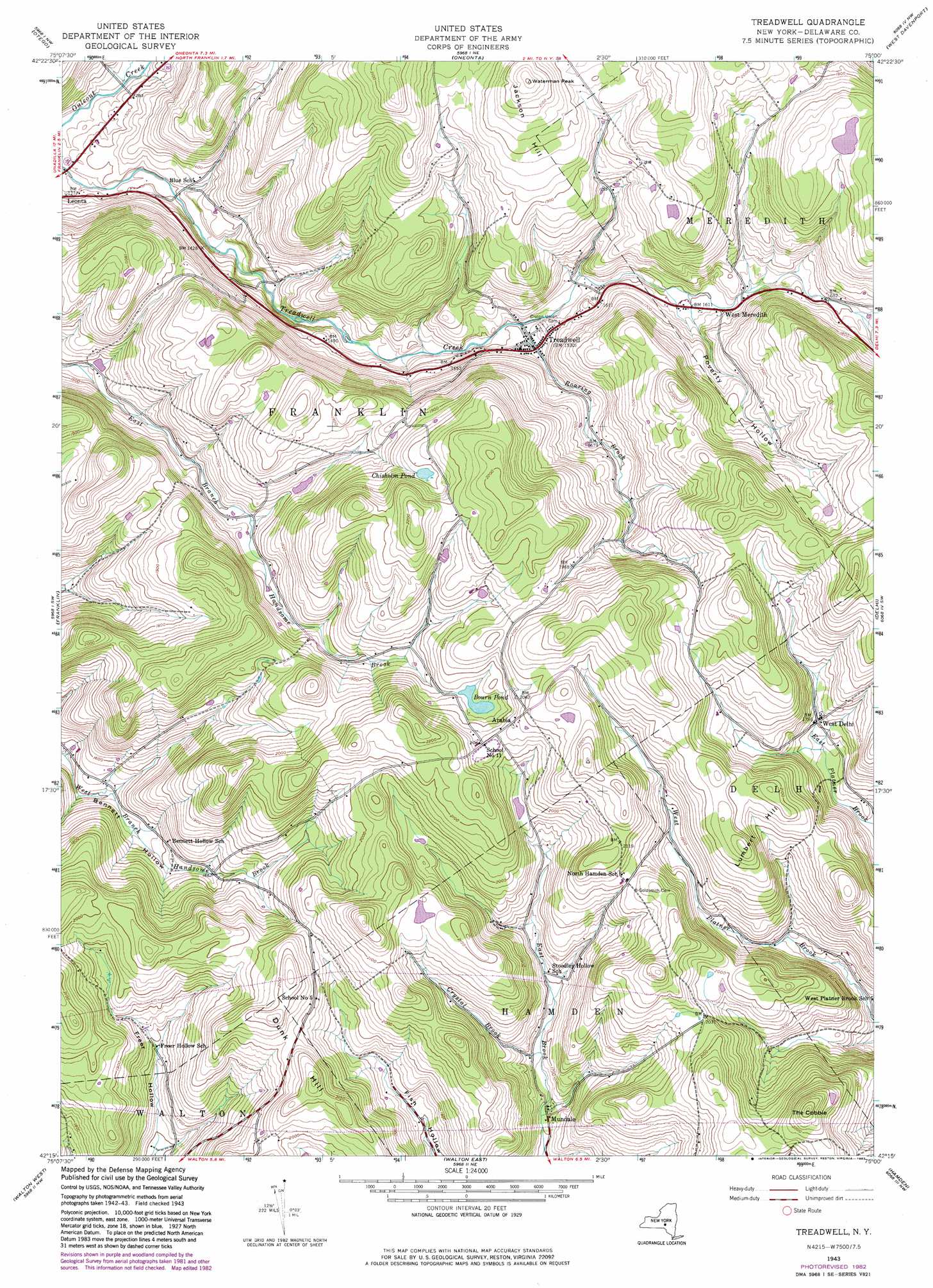
Treadwell Topo Map New York
To zoom in, hover over the map of Treadwell
USGS Topo Quad 42075c1 - 1:24,000 scale
| Topo Map Name: | Treadwell |
| USGS Topo Quad ID: | 42075c1 |
| Print Size: | ca. 21 1/4" wide x 27" high |
| Southeast Coordinates: | 42.25° N latitude / 75° W longitude |
| Map Center Coordinates: | 42.3125° N latitude / 75.0625° W longitude |
| U.S. State: | NY |
| Filename: | o42075c1.jpg |
| Download Map JPG Image: | Treadwell topo map 1:24,000 scale |
| Map Type: | Topographic |
| Topo Series: | 7.5´ |
| Map Scale: | 1:24,000 |
| Source of Map Images: | United States Geological Survey (USGS) |
| Alternate Map Versions: |
Treadwell NY 1943, updated 1960 Download PDF Buy paper map Treadwell NY 1943, updated 1974 Download PDF Buy paper map Treadwell NY 1943, updated 1983 Download PDF Buy paper map Treadwell NY 2010 Download PDF Buy paper map Treadwell NY 2013 Download PDF Buy paper map Treadwell NY 2016 Download PDF Buy paper map |
1:24,000 Topo Quads surrounding Treadwell
New Berlin South |
Morris |
Mount Vision |
Milford |
Schenevus |
Gilbertsville |
Otego |
Oneonta |
West Davenport |
Davenport |
Unadilla |
Franklin |
Treadwell |
Delhi |
Bloomville |
Trout Creek |
Walton West |
Walton East |
Hamden |
Andes |
Cannonsville Reservoir |
Readburn |
Corbett |
Downsville |
Lewbeach |
> Back to 42075a1 at 1:100,000 scale
> Back to 42074a1 at 1:250,000 scale
> Back to U.S. Topo Maps home
Treadwell topo map: Gazetteer
Treadwell: Lakes
Bourn Pond elevation 594m 1948′Chisholm Pond elevation 606m 1988′
Treadwell: Populated Places
Arabia elevation 625m 2050′Mundale elevation 493m 1617′
Treadwell elevation 466m 1528′
West Delhi elevation 550m 1804′
West Meredith elevation 504m 1653′
Treadwell: Streams
Crystal Brook elevation 502m 1646′Roaring Brook elevation 451m 1479′
Treadwell: Summits
Dunk Hill elevation 666m 2185′Jackson Hill elevation 672m 2204′
Lumbert Hill elevation 667m 2188′
The Cobble elevation 714m 2342′
Waterman Peak elevation 672m 2204′
Treadwell: Valleys
Poverty Hollow elevation 490m 1607′Treadwell digital topo map on disk
Buy this Treadwell topo map showing relief, roads, GPS coordinates and other geographical features, as a high-resolution digital map file on DVD:
New York, Vermont, Connecticut & Western Massachusetts
Buy digital topo maps: New York, Vermont, Connecticut & Western Massachusetts