Rabbit Mountain Topo Map Oregon
To zoom in, hover over the map of Rabbit Mountain
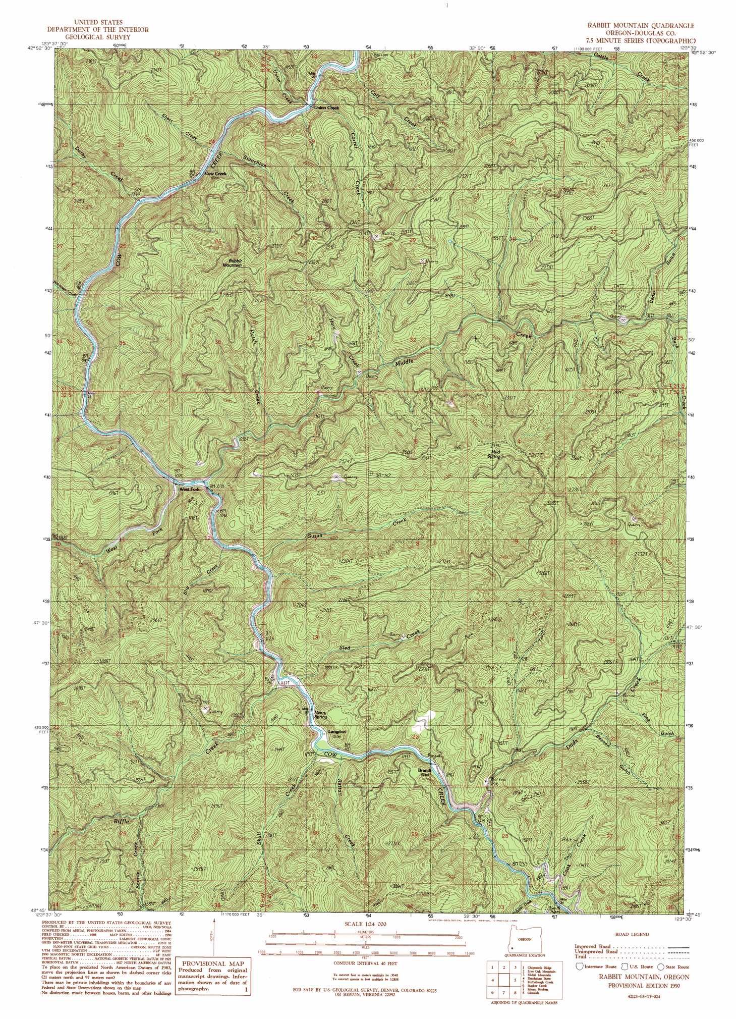
USGS Topo Quad 42123g5 - 1:24,000 scale
| Topo Map Name: | Rabbit Mountain |
| USGS Topo Quad ID: | 42123g5 |
| Print Size: | ca. 21 1/4" wide x 27" high |
| Southeast Coordinates: | 42.75° N latitude / 123.5° W longitude |
| Map Center Coordinates: | 42.8125° N latitude / 123.5625° W longitude |
| U.S. State: | OR |
| Filename: | o42123g5.jpg |
| Download Map JPG Image: | Rabbit Mountain topo map 1:24,000 scale |
| Map Type: | Topographic |
| Topo Series: | 7.5´ |
| Map Scale: | 1:24,000 |
| Source of Map Images: | United States Geological Survey (USGS) |
| Alternate Map Versions: |
Rabbit Mountain OR 1990, updated 1990 Download PDF Buy paper map Rabbit Mountain OR 2011 Download PDF Buy paper map Rabbit Mountain OR 2014 Download PDF Buy paper map |
1:24,000 Topo Quads surrounding Rabbit Mountain
Kenyon Mountain |
Camas Valley |
Tenmile |
Winston |
Myrtle Creek |
Bone Mountain |
Chipmunk Ridge |
Live Oak Mountain |
Nickel Mountain |
Canyonville |
Mount Bolivar |
Dutchman Butte |
Rabbit Mountain |
Mccullough Creek |
Quines Creek |
Kelsey Peak |
Bunker Creek |
Mount Reuben |
Glendale |
Golden |
Hobson Horn |
Mount Peavine |
Galice |
Merlin |
Sexton Mountain |
> Back to 42123e1 at 1:100,000 scale
> Back to 42122a1 at 1:250,000 scale
> Back to U.S. Topo Maps home
Rabbit Mountain topo map: Gazetteer
Rabbit Mountain: Populated Places
Cow Creek elevation 278m 912′Rabbit Mountain: Post Offices
Dothan Post Office (historical) elevation 316m 1036′Herman Post Office (historical) elevation 304m 997′
Rabbit Mountain: Springs
Henry Spring elevation 394m 1292′Mud Spring elevation 814m 2670′
Rabbit Mountain: Streams
Bonnie Creek elevation 428m 1404′Boulder Creek elevation 271m 889′
Buck Creek elevation 423m 1387′
Calf Creek elevation 273m 895′
Cook Creek elevation 385m 1263′
Corral Creek elevation 290m 951′
Dads Creek elevation 373m 1223′
Darby Creek elevation 286m 938′
Dutchman Creek elevation 291m 954′
Hare Creek elevation 354m 1161′
Hutch Creek elevation 326m 1069′
Knupp Creek elevation 386m 1266′
Middle Creek elevation 315m 1033′
Rattail Creek elevation 355m 1164′
Riffle Creek elevation 335m 1099′
Short Creek elevation 328m 1076′
Skull Creek elevation 395m 1295′
Sled Creek elevation 342m 1122′
Slip Creek elevation 327m 1072′
Stanchion Creek elevation 328m 1076′
Sullivan Creek elevation 607m 1991′
Susan Creek elevation 328m 1076′
Tuller Creek elevation 381m 1250′
Union Creek elevation 273m 895′
West Fork Cow Creek elevation 564m 1850′
Rabbit Mountain: Summits
Rabbit Mountain elevation 959m 3146′Rabbit Mountain: Valleys
Benson Gulch elevation 486m 1594′Cedar Gulch elevation 426m 1397′
Ping Gulch elevation 485m 1591′
Rabbit Mountain digital topo map on disk
Buy this Rabbit Mountain topo map showing relief, roads, GPS coordinates and other geographical features, as a high-resolution digital map file on DVD: