Adrian Topo Map Oregon
To zoom in, hover over the map of Adrian
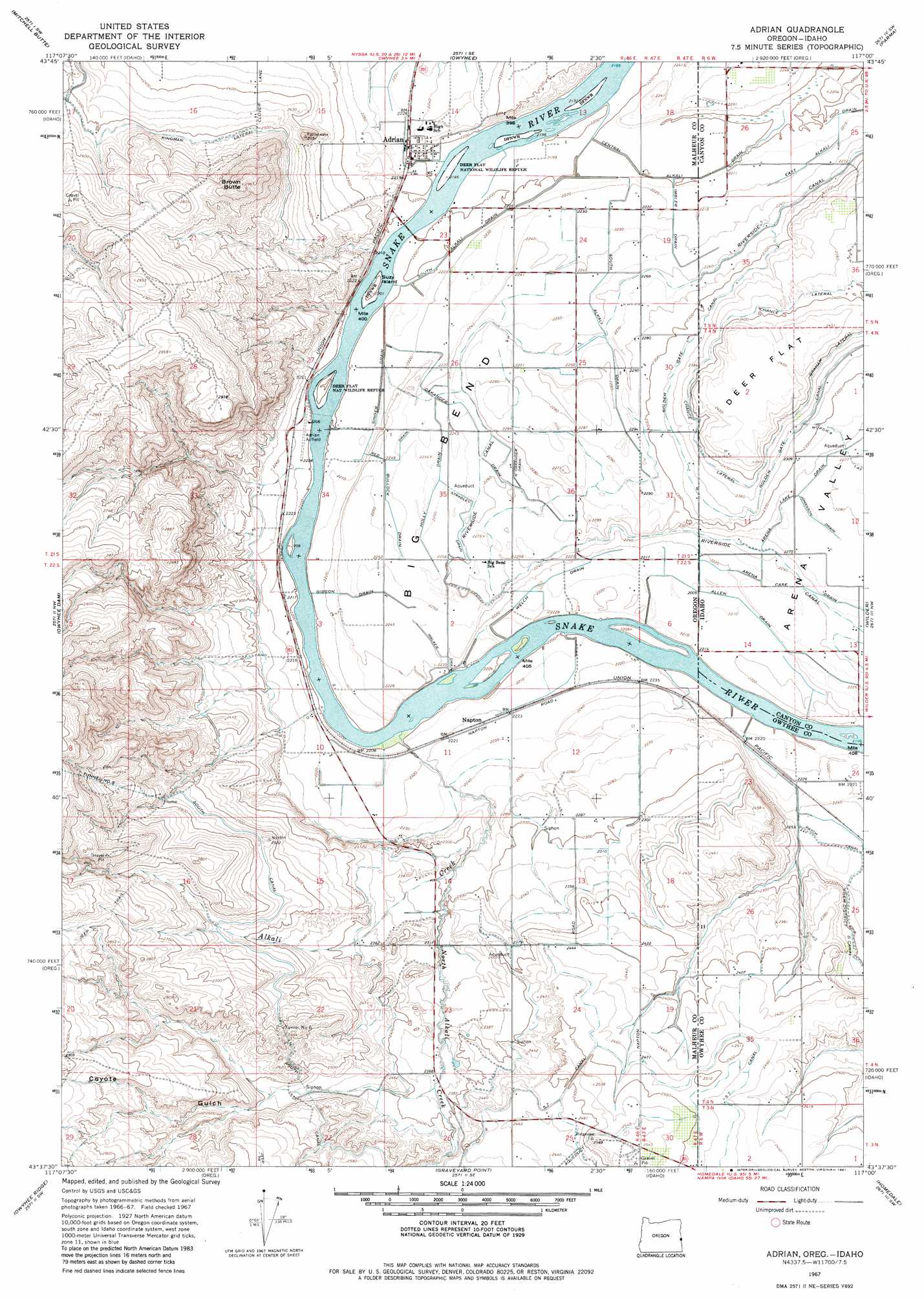
USGS Topo Quad 43117f1 - 1:24,000 scale
| Topo Map Name: | Adrian |
| USGS Topo Quad ID: | 43117f1 |
| Print Size: | ca. 21 1/4" wide x 27" high |
| Southeast Coordinates: | 43.625° N latitude / 117° W longitude |
| Map Center Coordinates: | 43.6875° N latitude / 117.0625° W longitude |
| U.S. States: | OR, ID |
| Filename: | o43117f1.jpg |
| Download Map JPG Image: | Adrian topo map 1:24,000 scale |
| Map Type: | Topographic |
| Topo Series: | 7.5´ |
| Map Scale: | 1:24,000 |
| Source of Map Images: | United States Geological Survey (USGS) |
| Alternate Map Versions: |
Adrian OR 1967, updated 1971 Download PDF Buy paper map Adrian OR 1967, updated 1981 Download PDF Buy paper map Adrian OR 2011 Download PDF Buy paper map Adrian OR 2014 Download PDF Buy paper map |
1:24,000 Topo Quads surrounding Adrian
Vale West |
Vale East |
Cairo |
Nyssa |
New Plymouth |
Double Mountain |
Mitchell Butte |
Owyhee |
Parma |
Parma Se |
Grassy Mountain |
Owyhee Dam |
Adrian |
Wilder |
Notus |
The Elbow |
Owyhee Ridge |
Graveyard Point |
Homedale |
Marsing |
Pelican Point |
Three Fingers Rock |
Pole Creek Top |
Jump Creek Canyon |
Opalene Gulch |
> Back to 43117e1 at 1:100,000 scale
> Back to 43116a1 at 1:250,000 scale
> Back to U.S. Topo Maps home
Adrian topo map: Gazetteer
Adrian: Bends
Big Bend elevation 687m 2253′Adrian: Canals
Allen Drain elevation 674m 2211′Arena Case Drain elevation 679m 2227′
Bullock Drain elevation 686m 2250′
Central Alkali Drain elevation 672m 2204′
Central Alkali Drain elevation 672m 2204′
Chance Lateral elevation 728m 2388′
Chance Lateral elevation 726m 2381′
Coyote Gulch Siphon elevation 750m 2460′
Five and Seventenths Canal elevation 755m 2477′
Gibson Drain elevation 684m 2244′
Golden Gate Canal elevation 710m 2329′
Graham Lateral elevation 731m 2398′
Holly Drain elevation 684m 2244′
Imbler Drain elevation 678m 2224′
North Oakander Drain elevation 690m 2263′
Oakander Drain elevation 685m 2247′
Red Drain elevation 687m 2253′
Riverside Canal elevation 689m 2260′
Singer Drain elevation 672m 2204′
South Alkali Drain elevation 693m 2273′
South Canal elevation 775m 2542′
Stradley Drain elevation 689m 2260′
Walker Drain elevation 684m 2244′
Welch Drain elevation 674m 2211′
Adrian: Flats
Deer Flat elevation 749m 2457′Adrian: Islands
Suzy Island elevation 675m 2214′Adrian: Parks
Big Bend Park elevation 699m 2293′Adrian: Populated Places
Adrian elevation 680m 2230′Adrian: Post Offices
Adrian Post Office elevation 680m 2230′Adrian: Streams
Alkali Creek elevation 670m 2198′Allen Drain elevation 675m 2214′
Imbler Drain elevation 678m 2224′
Johanson Drain elevation 693m 2273′
North Alkali Creek elevation 696m 2283′
Adrian: Summits
Brown Butte elevation 905m 2969′Adrian: Tunnels
Tunnel Number 6 elevation 799m 2621′Adrian: Valleys
Arena Valley elevation 678m 2224′Coyote Gulch elevation 722m 2368′
Adrian digital topo map on disk
Buy this Adrian topo map showing relief, roads, GPS coordinates and other geographical features, as a high-resolution digital map file on DVD: