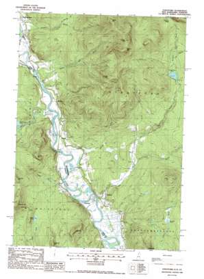
Stratford Topo Map New Hampshire
To zoom in, hover over the map of Stratford
USGS Topo Quad 44071f5 - 1:24,000 scale
| Topo Map Name: | Stratford |
| USGS Topo Quad ID: | 44071f5 |
| Print Size: | ca. 21 1/4" wide x 27" high |
| Southeast Coordinates: | 44.625° N latitude / 71.5° W longitude |
| Map Center Coordinates: | 44.6875° N latitude / 71.5625° W longitude |
| U.S. States: | NH, VT |
| Filename: | o44071f5.jpg |
| Download Map JPG Image: | Stratford topo map 1:24,000 scale |
| Map Type: | Topographic |
| Topo Series: | 7.5´ |
| Map Scale: | 1:24,000 |
| Source of Map Images: | United States Geological Survey (USGS) |
| Alternate Map Versions: |
Stratford NH 1988, updated 1988 Download PDF Buy paper map Stratford NH 2012 Download PDF Buy paper map Stratford NH 2015 Download PDF Buy paper map |
1:24,000 Topo Quads surrounding Stratford
> Back to 44071e1 at 1:100,000 scale
> Back to 44070a1 at 1:250,000 scale
> Back to U.S. Topo Maps home
Stratford topo map: Gazetteer
Stratford: Dams
Stratford Bog Pond Dam elevation 485m 1591′Stratford: Gaps
Stratford Notch elevation 657m 2155′Stratford: Islands
Hinman Island elevation 267m 875′Mason Island elevation 262m 859′
Mason Island elevation 263m 862′
Stratford: Lakes
Dutton Pond elevation 380m 1246′Hoskins Pond elevation 268m 879′
Jonathan Pond elevation 374m 1227′
Paul Stream Pond elevation 313m 1026′
Stratford: Populated Places
Beatties elevation 301m 987′Maidstone elevation 263m 862′
Mapleton elevation 283m 928′
Masons elevation 288m 944′
Stratford elevation 267m 875′
Stratford: Reservoirs
Stratford Bog Pond elevation 485m 1591′Stratford: Streams
Bissell Brook elevation 264m 866′Bog Brook elevation 263m 862′
Connary Brook elevation 262m 859′
East Branch Bog Brook elevation 286m 938′
East Branch Stratford Bog Brook elevation 491m 1610′
Gay Brook elevation 332m 1089′
Kimball Brook elevation 265m 869′
Paul Stream elevation 260m 853′
Rich Brook elevation 280m 918′
Roaring Brook elevation 410m 1345′
Stratford Bog Brook elevation 486m 1594′
Sugarloaf Brook elevation 478m 1568′
Taylor Brook elevation 259m 849′
Wheeler Stream elevation 267m 875′
Stratford: Summits
Bear Mountain elevation 530m 1738′Goback Mountain elevation 1054m 3458′
Hedgehog Mountain elevation 527m 1729′
Lake Mountain elevation 524m 1719′
Maidstone Hill elevation 456m 1496′
Morse Mountain elevation 550m 1804′
Potato Hill elevation 617m 2024′
Savage Mountain elevation 1059m 3474′
Spruce Mountain elevation 884m 2900′
Stoneham Mountain elevation 628m 2060′
Teapot Mountain elevation 981m 3218′
Willard Mountain elevation 526m 1725′
Stratford digital topo map on disk
Buy this Stratford topo map showing relief, roads, GPS coordinates and other geographical features, as a high-resolution digital map file on DVD:
Maine, New Hampshire, Rhode Island & Eastern Massachusetts
Buy digital topo maps: Maine, New Hampshire, Rhode Island & Eastern Massachusetts


