Saddle Mountain Topo Map Idaho
To zoom in, hover over the map of Saddle Mountain
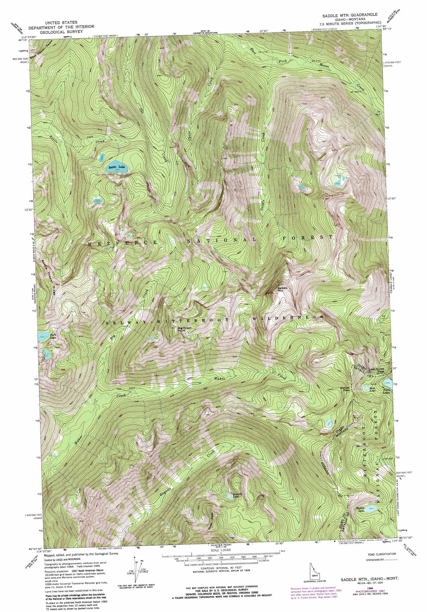
USGS Topo Quad 46114b5 - 1:24,000 scale
| Topo Map Name: | Saddle Mountain |
| USGS Topo Quad ID: | 46114b5 |
| Print Size: | ca. 21 1/4" wide x 27" high |
| Southeast Coordinates: | 46.125° N latitude / 114.5° W longitude |
| Map Center Coordinates: | 46.1875° N latitude / 114.5625° W longitude |
| U.S. States: | ID, MT |
| Filename: | o46114b5.jpg |
| Download Map JPG Image: | Saddle Mountain topo map 1:24,000 scale |
| Map Type: | Topographic |
| Topo Series: | 7.5´ |
| Map Scale: | 1:24,000 |
| Source of Map Images: | United States Geological Survey (USGS) |
| Alternate Map Versions: |
Saddle Mtn. ID 1966, updated 1968 Download PDF Buy paper map Saddle Mountain ID 1966, updated 1987 Download PDF Buy paper map Saddle Mountain ID 1995, updated 1999 Download PDF Buy paper map Saddle Mountain ID 2011 Download PDF Buy paper map Saddle Mountain ID 2013 Download PDF Buy paper map |
| FStopo: | US Forest Service topo Saddle Mountain is available: Download FStopo PDF Download FStopo TIF |
1:24,000 Topo Quads surrounding Saddle Mountain
Tom Beal Peak |
Grave Peak |
Savage Ridge |
White Sand Lake |
Gash Point |
Hungry Rock |
Cedar Ridge |
Jeanette Mountain |
Blodgett Mountain |
Printz Ridge |
Freeman Peak |
Wahoo Peak |
Saddle Mountain |
Tenmile Lake |
Ward Mountain |
Dog Creek |
Twin Butte |
Hunter Peak |
El Capitan |
Como Peaks |
Gardiner Peak |
Mount George |
Mount Paloma |
Tin Cup Lake |
Trapper Peak |
> Back to 46114a1 at 1:100,000 scale
> Back to 46114a1 at 1:250,000 scale
> Back to U.S. Topo Maps home
Saddle Mountain topo map: Gazetteer
Saddle Mountain: Gaps
Lost Horse Pass elevation 2022m 6633′Lost Horse Pass elevation 2022m 6633′
Wahoo Pass elevation 2158m 7080′
Wahoo Pass elevation 2158m 7080′
Saddle Mountain: Lakes
Battle Lake elevation 2021m 6630′Granite Lake elevation 2044m 6706′
Park Lake elevation 2067m 6781′
Saddle Mountain: Streams
Big Creek elevation 1562m 5124′Saddle Creek elevation 1440m 4724′
Saddle Mountain: Summits
Big Creek Point elevation 2341m 7680′Cove Peak elevation 2294m 7526′
Saddle Mountain elevation 2498m 8195′
Saddle Mountain digital topo map on disk
Buy this Saddle Mountain topo map showing relief, roads, GPS coordinates and other geographical features, as a high-resolution digital map file on DVD: