Gash Point Topo Map Montana
To zoom in, hover over the map of Gash Point
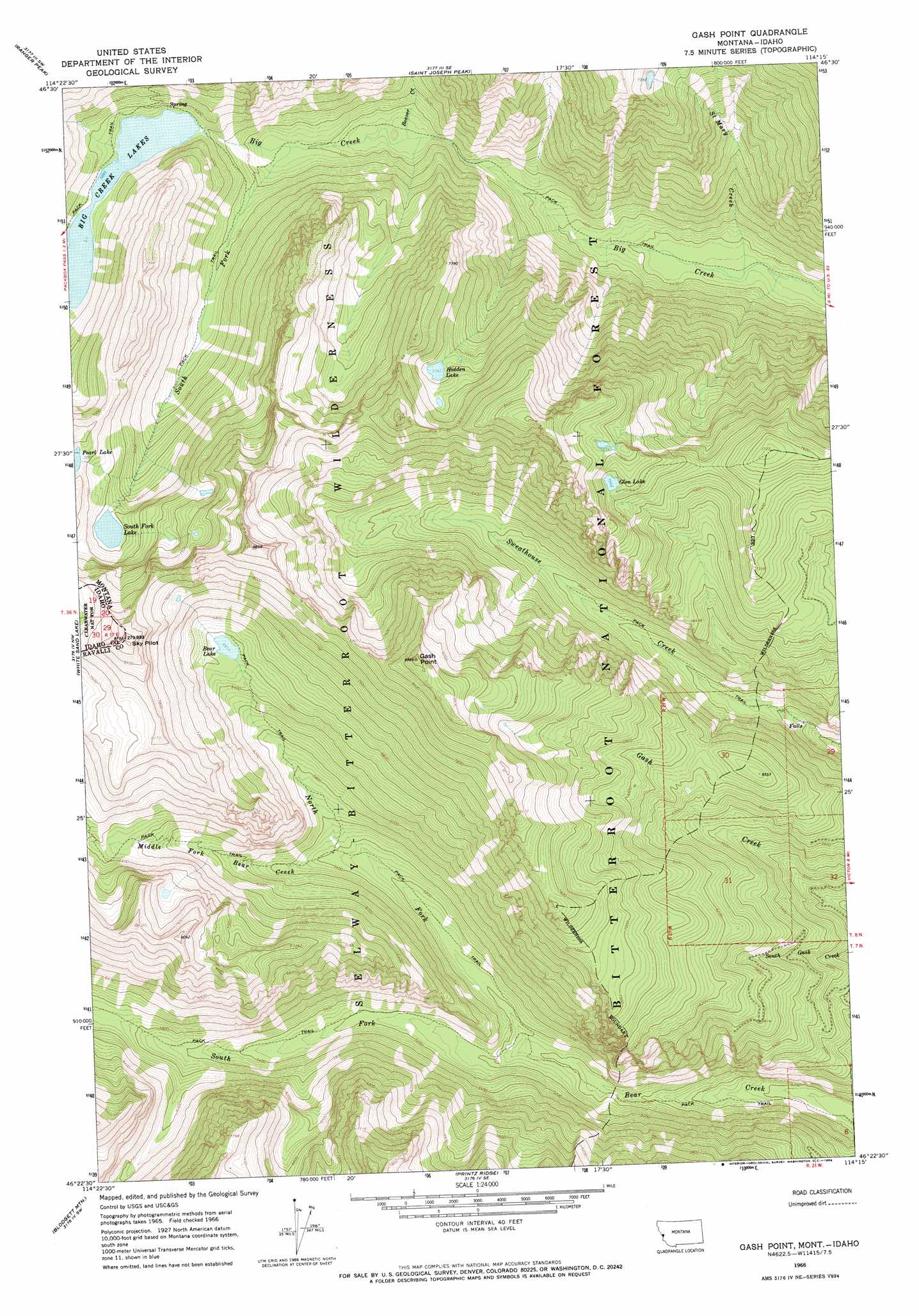
USGS Topo Quad 46114d3 - 1:24,000 scale
| Topo Map Name: | Gash Point |
| USGS Topo Quad ID: | 46114d3 |
| Print Size: | ca. 21 1/4" wide x 27" high |
| Southeast Coordinates: | 46.375° N latitude / 114.25° W longitude |
| Map Center Coordinates: | 46.4375° N latitude / 114.3125° W longitude |
| U.S. States: | MT, ID |
| Filename: | o46114d3.jpg |
| Download Map JPG Image: | Gash Point topo map 1:24,000 scale |
| Map Type: | Topographic |
| Topo Series: | 7.5´ |
| Map Scale: | 1:24,000 |
| Source of Map Images: | United States Geological Survey (USGS) |
| Alternate Map Versions: |
Gash Point MT 1966, updated 1969 Download PDF Buy paper map Gash Point MT 1998, updated 2002 Download PDF Buy paper map Gash Point MT 2011 Download PDF Buy paper map Gash Point MT 2014 Download PDF Buy paper map |
| FStopo: | US Forest Service topo Gash Point is available: Download FStopo PDF Download FStopo TIF |
1:24,000 Topo Quads surrounding Gash Point
Lolo Hot Springs |
West Fork Butte |
Dick Creek |
Carlton Lake |
Florence |
Roundtop |
Ranger Peak |
Saint Joseph Peak |
Saint Mary Peak |
Stevensville |
Savage Ridge |
White Sand Lake |
Gash Point |
Victor |
Bing |
Jeanette Mountain |
Blodgett Mountain |
Printz Ridge |
Hamilton North |
Corvallis |
Saddle Mountain |
Tenmile Lake |
Ward Mountain |
Hamilton South |
Mountain House |
> Back to 46114a1 at 1:100,000 scale
> Back to 46114a1 at 1:250,000 scale
> Back to U.S. Topo Maps home
Gash Point topo map: Gazetteer
Gash Point: Dams
Big Creek Lake Dam elevation 1789m 5869′Big Creek Number 2 Dam elevation 1789m 5869′
Gash Point: Lakes
Bear Lake elevation 2006m 6581′Big Creek Lakes elevation 1789m 5869′
Glen Lake elevation 2299m 7542′
Hidden Lake elevation 2177m 7142′
South Fork Lake elevation 2068m 6784′
Gash Point: Mines
Starr Mine elevation 1671m 5482′Gash Point: Reservoirs
Big Creek Lake elevation 1789m 5869′Gash Point: Streams
Beaver Creek elevation 1544m 5065′Middle Fork Bear Creek elevation 1622m 5321′
North Fork Bear Creek elevation 1472m 4829′
Saint Mary Creek elevation 1315m 4314′
South Fork Bear Creek elevation 1472m 4829′
South Fork Big Creek elevation 1592m 5223′
Gash Point: Summits
Gash Point elevation 2664m 8740′Gash Point digital topo map on disk
Buy this Gash Point topo map showing relief, roads, GPS coordinates and other geographical features, as a high-resolution digital map file on DVD: