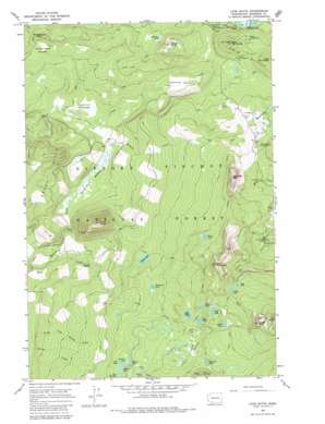
Lone Butte Topo Map Washington
To zoom in, hover over the map of Lone Butte
USGS Topo Quad 46121a7 - 1:24,000 scale
| Topo Map Name: | Lone Butte |
| USGS Topo Quad ID: | 46121a7 |
| Print Size: | ca. 21 1/4" wide x 27" high |
| Southeast Coordinates: | 46° N latitude / 121.75° W longitude |
| Map Center Coordinates: | 46.0625° N latitude / 121.8125° W longitude |
| U.S. State: | WA |
| Filename: | o46121a7.jpg |
| Download Map JPG Image: | Lone Butte topo map 1:24,000 scale |
| Map Type: | Topographic |
| Topo Series: | 7.5´ |
| Map Scale: | 1:24,000 |
| Source of Map Images: | United States Geological Survey (USGS) |
| Alternate Map Versions: |
Lone Butte WA 1965, updated 1967 Download PDF Buy paper map Lone Butte WA 1965, updated 1980 Download PDF Buy paper map Lone Butte WA 1998, updated 2003 Download PDF Buy paper map Lone Butte WA 2011 Download PDF Buy paper map Lone Butte WA 2014 Download PDF Buy paper map |
| FStopo: | US Forest Service topo Lone Butte is available: Download FStopo PDF Download FStopo TIF |
1:24,000 Topo Quads surrounding Lone Butte
> Back to 46121a1 at 1:100,000 scale
> Back to 46120a1 at 1:250,000 scale
> Back to U.S. Topo Maps home
Lone Butte topo map: Gazetteer
Lone Butte: Flats
Cayuse Meadow elevation 1082m 3549′Hungry Peak Meadow elevation 1151m 3776′
Lone Butte Meadows elevation 998m 3274′
Skookum Meadow elevation 994m 3261′
Lone Butte: Lakes
Acker Lake elevation 1412m 4632′Bear Lake elevation 1448m 4750′
Brader Lake elevation 1364m 4475′
Chenamus Lake elevation 1302m 4271′
Clear Lake elevation 1507m 4944′
Cold Spring Lake elevation 1277m 4189′
Cultus Lake elevation 1546m 5072′
Dee Lake elevation 1310m 4297′
Deep Lake elevation 1556m 5104′
Deer Lake elevation 1472m 4829′
Elk Lake elevation 1429m 4688′
Eunice Lake elevation 1316m 4317′
Frog Lake elevation 1240m 4068′
Heather Lake elevation 1314m 4311′
Indian Heaven Lakes elevation 1523m 4996′
Junction Lake elevation 1450m 4757′
Lake Kwaddis elevation 1315m 4314′
Lemei Lake elevation 1484m 4868′
Little Mosquito Lake elevation 1193m 3914′
Meadow Lake elevation 1229m 4032′
Placid Lake elevation 1233m 4045′
Surprise Lakes elevation 1295m 4248′
Thomas Lake elevation 1312m 4304′
Wood Lake elevation 1485m 4872′
Lone Butte: Mines
Lone Butte Quarry elevation 1282m 4206′Lone Butte: Streams
Meadow Creek elevation 889m 2916′Lone Butte: Summits
Bird Mountain elevation 1732m 5682′East Twin Butte elevation 1426m 4678′
Hungry Peak elevation 1232m 4041′
Lemei Rock elevation 1793m 5882′
Lone Butte elevation 1453m 4767′
Sawtooth Mountain elevation 1621m 5318′
Squaw Butte elevation 1389m 4557′
Twin Buttes elevation 1277m 4189′
West Twin Butte elevation 1424m 4671′
Lone Butte digital topo map on disk
Buy this Lone Butte topo map showing relief, roads, GPS coordinates and other geographical features, as a high-resolution digital map file on DVD:


