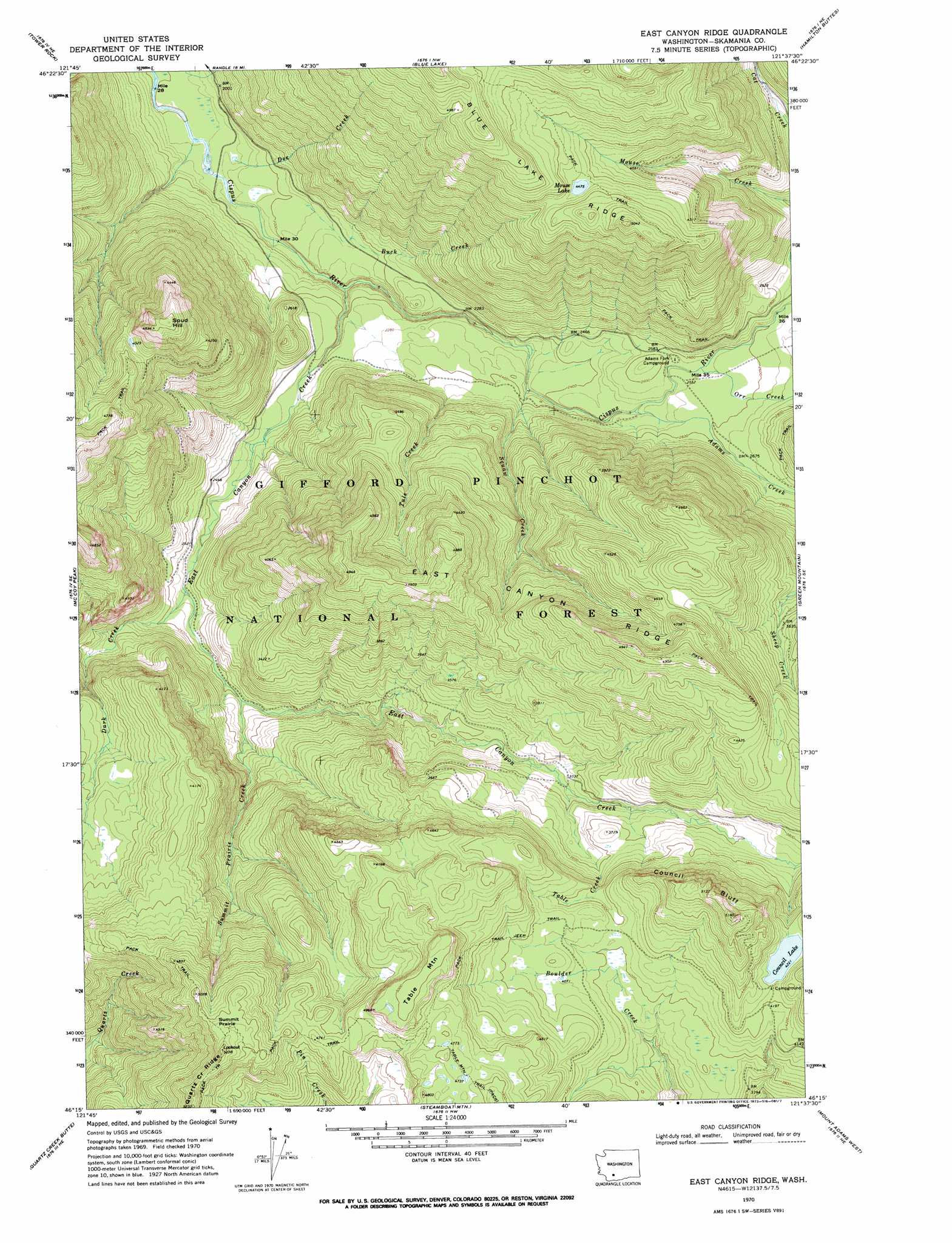
East Canyon Ridge Topo Map Washington
To zoom in, hover over the map of East Canyon Ridge
USGS Topo Quad 46121c6 - 1:24,000 scale
| Topo Map Name: | East Canyon Ridge |
| USGS Topo Quad ID: | 46121c6 |
| Print Size: | ca. 21 1/4" wide x 27" high |
| Southeast Coordinates: | 46.25° N latitude / 121.625° W longitude |
| Map Center Coordinates: | 46.3125° N latitude / 121.6875° W longitude |
| U.S. State: | WA |
| Filename: | o46121c6.jpg |
| Download Map JPG Image: | East Canyon Ridge topo map 1:24,000 scale |
| Map Type: | Topographic |
| Topo Series: | 7.5´ |
| Map Scale: | 1:24,000 |
| Source of Map Images: | United States Geological Survey (USGS) |
| Alternate Map Versions: |
East Canyon Ridge WA 1970, updated 1973 Download PDF Buy paper map East Canyon Ridge WA 1994, updated 1996 Download PDF Buy paper map East Canyon Ridge WA 2011 Download PDF Buy paper map East Canyon Ridge WA 2014 Download PDF Buy paper map |
| FStopo: | US Forest Service topo East Canyon Ridge is available: Download FStopo PDF Download FStopo TIF |
1:24,000 Topo Quads surrounding East Canyon Ridge
Randle |
Purcell Mountain |
Packwood |
Packwood Lake |
Old Snowy Mountain |
Greenhorn Buttes |
Tower Rock |
Blue Lake |
Hamilton Buttes |
Walupt Lake |
French Butte |
Mccoy Peak |
East Canyon Ridge |
Green Mountain |
Glaciate Butte |
Spencer Butte |
Quartz Creek Butte |
Steamboat Mountain |
Mount Adams West |
Mount Adams East |
Burnt Peak |
Lone Butte |
Sleeping Beauty |
Trout Lake |
King Mountain |
> Back to 46121a1 at 1:100,000 scale
> Back to 46120a1 at 1:250,000 scale
> Back to U.S. Topo Maps home
East Canyon Ridge topo map: Gazetteer
East Canyon Ridge: Cliffs
Council Bluff elevation 1535m 5036′East Canyon Ridge: Flats
Summit Prairie elevation 1554m 5098′East Canyon Ridge: Lakes
Council Lake elevation 1288m 4225′Mouse Lake elevation 1361m 4465′
East Canyon Ridge: Ridges
East Canyon Ridge elevation 1479m 4852′East Canyon Ridge: Streams
Adams Creek elevation 745m 2444′Buck Creek elevation 634m 2080′
Dark Creek elevation 759m 2490′
Doe Creek elevation 573m 1879′
East Canyon Creek elevation 608m 1994′
Orr Creek elevation 773m 2536′
Prospect Creek elevation 559m 1833′
Squaw Creek elevation 721m 2365′
Summit Prairie Creek elevation 798m 2618′
Table Creek elevation 1014m 3326′
Tule Creek elevation 754m 2473′
East Canyon Ridge: Summits
Spud Hill elevation 1478m 4849′Table Mountain elevation 1530m 5019′
East Canyon Ridge digital topo map on disk
Buy this East Canyon Ridge topo map showing relief, roads, GPS coordinates and other geographical features, as a high-resolution digital map file on DVD: