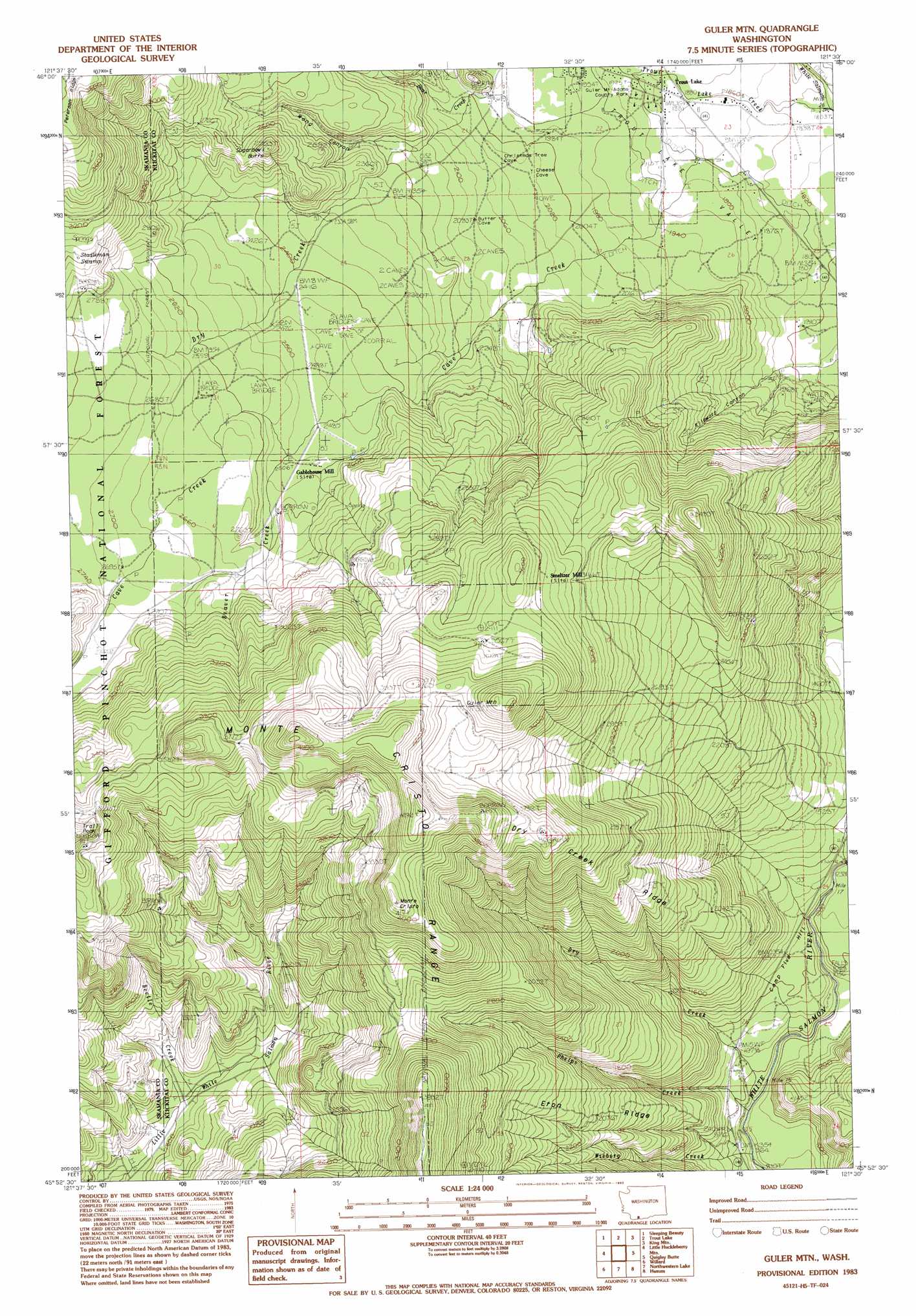
Guler Mountain Topo Map Washington
To zoom in, hover over the map of Guler Mountain
USGS Topo Quad 45121h5 - 1:24,000 scale
| Topo Map Name: | Guler Mountain |
| USGS Topo Quad ID: | 45121h5 |
| Print Size: | ca. 21 1/4" wide x 27" high |
| Southeast Coordinates: | 45.875° N latitude / 121.5° W longitude |
| Map Center Coordinates: | 45.9375° N latitude / 121.5625° W longitude |
| U.S. State: | WA |
| Filename: | o45121h5.jpg |
| Download Map JPG Image: | Guler Mountain topo map 1:24,000 scale |
| Map Type: | Topographic |
| Topo Series: | 7.5´ |
| Map Scale: | 1:24,000 |
| Source of Map Images: | United States Geological Survey (USGS) |
| Alternate Map Versions: |
Guler Mtn WA 1983, updated 1983 Download PDF Buy paper map Guler Mountain WA 1998, updated 2003 Download PDF Buy paper map Guler Mountain WA 2011 Download PDF Buy paper map Guler Mountain WA 2014 Download PDF Buy paper map |
| FStopo: | US Forest Service topo Guler Mountain is available: Download FStopo PDF Download FStopo TIF |
1:24,000 Topo Quads surrounding Guler Mountain
Quartz Creek Butte |
Steamboat Mountain |
Mount Adams West |
Mount Adams East |
Jungle Butte |
Lone Butte |
Sleeping Beauty |
Trout Lake |
King Mountain |
Glenwood |
Gifford Peak |
Little Huckleberry Mountain |
Guler Mountain |
Quigley Butte |
Camas Prairie |
Big Huckleberry Mountain |
Willard |
Northwestern Lake |
Husum |
Appleton |
Carson |
Mount Defiance |
Hood River |
White Salmon |
Lyle |
> Back to 45121e1 at 1:100,000 scale
> Back to 45120a1 at 1:250,000 scale
> Back to U.S. Topo Maps home
Guler Mountain topo map: Gazetteer
Guler Mountain: Arches
Lava Bridge elevation 789m 2588′Guler Mountain: Parks
Guler Mount Adams County Park elevation 590m 1935′Guler Mountain: Populated Places
Guler elevation 594m 1948′Trout Lake elevation 577m 1893′
Guler Mountain: Ranges
Monte Cristo Range elevation 1049m 3441′Guler Mountain: Ridges
Dry Creek Ridge elevation 1004m 3293′Eton Ridge elevation 620m 2034′
Guler Mountain: Streams
Bear Creek elevation 620m 2034′Beaver Creek elevation 763m 2503′
Beetle Creek elevation 558m 1830′
Cave Creek elevation 574m 1883′
Dry Creek elevation 283m 928′
Dry Creek elevation 604m 1981′
Phelps Creek elevation 282m 925′
Spring Creek elevation 642m 2106′
Trout Lake Creek elevation 557m 1827′
Wieberg Creek elevation 289m 948′
Guler Mountain: Summits
Camp Five Hill elevation 387m 1269′Guler Mountain elevation 1288m 4225′
Monte Cristo elevation 1243m 4078′
Sugarbowl Butte elevation 868m 2847′
Trail Peak elevation 1186m 3891′
Guler Mountain: Swamps
Stadleman Swamp elevation 905m 2969′Guler Mountain: Trails
Little White Salmon Trail elevation 817m 2680′Oklahoma Trail elevation 911m 2988′
Guler Mountain: Valleys
Bear Valley elevation 383m 1256′Kilowatt Canyon elevation 558m 1830′
Wang Canyon elevation 685m 2247′
Guler Mountain digital topo map on disk
Buy this Guler Mountain topo map showing relief, roads, GPS coordinates and other geographical features, as a high-resolution digital map file on DVD: