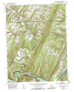
Bellegrove Topo Map Maryland
To zoom in, hover over the map of Bellegrove
USGS Topo Quad 39078f3 - 1:24,000 scale
| Topo Map Name: | Bellegrove |
| USGS Topo Quad ID: | 39078f3 |
| Print Size: | ca. 21 1/4" wide x 27" high |
| Southeast Coordinates: | 39.625° N latitude / 78.25° W longitude |
| Map Center Coordinates: | 39.6875° N latitude / 78.3125° W longitude |
| U.S. States: | MD, WV, PA |
| Filename: | o39078f3.jpg |
| Download Map JPG Image: | Bellegrove topo map 1:24,000 scale |
| Map Type: | Topographic |
| Topo Series: | 7.5´ |
| Map Scale: | 1:24,000 |
| Source of Map Images: | United States Geological Survey (USGS) |
| Alternate Map Versions: |
Bellegrove MD 1951, updated 1952 Download PDF Buy paper map Bellegrove MD 1951, updated 1952 Download PDF Buy paper map Bellegrove MD 1951, updated 1965 Download PDF Buy paper map Bellegrove MD 1951, updated 1969 Download PDF Buy paper map Bellegrove MD 1951, updated 1975 Download PDF Buy paper map Bellegrove MD 1951, updated 1986 Download PDF Buy paper map Bellegrove MD 1951, updated 1987 Download PDF Buy paper map Bellegrove MD 1996, updated 1999 Download PDF Buy paper map Bellegrove MD 2011 Download PDF Buy paper map Bellegrove MD 2014 Download PDF Buy paper map Bellegrove MD 2016 Download PDF Buy paper map |
1:24,000 Topo Quads surrounding Bellegrove
> Back to 39078e1 at 1:100,000 scale
> Back to 39078a1 at 1:250,000 scale
> Back to U.S. Topo Maps home
Bellegrove topo map: Gazetteer
Bellegrove: Bends
Turkey Foot Bend elevation 138m 452′Bellegrove: Bridges
Sideling Hill Creek Aqueduct elevation 131m 429′Bellegrove: Dams
Lake Jenkins Dam elevation 151m 495′Lake Lanahen Dam elevation 155m 508′
Lock 55 elevation 128m 419′
Lock 56 elevation 135m 442′
Lock 57 elevation 136m 446′
Bellegrove: Parks
Sideling Hill Wildlife Management Area elevation 458m 1502′Bellegrove: Populated Places
Barnes Gap elevation 251m 823′Bellegrove elevation 200m 656′
Cohill elevation 138m 452′
Exline elevation 269m 882′
Forest Park elevation 341m 1118′
Harvey elevation 285m 935′
Lineburg elevation 141m 462′
Mann elevation 293m 961′
Pearre elevation 143m 469′
Woodmont elevation 138m 452′
Woodmont elevation 147m 482′
Bellegrove: Reservoirs
Lake Edward Elliote Jenkins elevation 159m 521′Lake Jenkins elevation 151m 495′
Lake Lanahan elevation 155m 508′
Lake Nesbit and Lanhan elevation 177m 580′
Bellegrove: Ridges
Long Ridge elevation 250m 820′Tonoloway Ridge elevation 325m 1066′
Bellegrove: Streams
Bear Creek elevation 188m 616′Bear Creek elevation 211m 692′
Crooked Run elevation 243m 797′
Crooked Run elevation 219m 718′
Sideling Hill Creek elevation 131m 429′
Sideling Hill Creek elevation 130m 426′
Stahle Run elevation 268m 879′
Trough Run elevation 244m 800′
Willett Run elevation 130m 426′
Bellegrove: Summits
High Germany Hill elevation 260m 853′Bellegrove: Tunnels
Indigo Tunnel elevation 259m 849′Bellegrove: Valleys
Long Hollow elevation 129m 423′Sawmill Hollow elevation 193m 633′
Swain Hollow elevation 170m 557′
Bellegrove digital topo map on disk
Buy this Bellegrove topo map showing relief, roads, GPS coordinates and other geographical features, as a high-resolution digital map file on DVD:


