Flintstone Topo Map Maryland
To zoom in, hover over the map of Flintstone
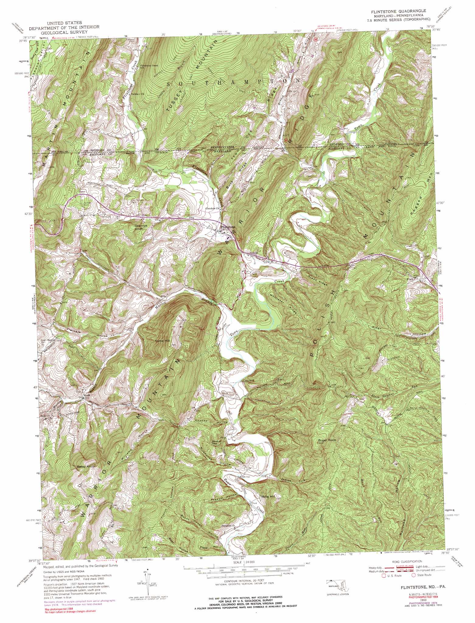
USGS Topo Quad 39078f5 - 1:24,000 scale
| Topo Map Name: | Flintstone |
| USGS Topo Quad ID: | 39078f5 |
| Print Size: | ca. 21 1/4" wide x 27" high |
| Southeast Coordinates: | 39.625° N latitude / 78.5° W longitude |
| Map Center Coordinates: | 39.6875° N latitude / 78.5625° W longitude |
| U.S. States: | MD, PA |
| Filename: | o39078f5.jpg |
| Download Map JPG Image: | Flintstone topo map 1:24,000 scale |
| Map Type: | Topographic |
| Topo Series: | 7.5´ |
| Map Scale: | 1:24,000 |
| Source of Map Images: | United States Geological Survey (USGS) |
| Alternate Map Versions: |
Flintstone MD 1950, updated 1972 Download PDF Buy paper map Flintstone MD 1950, updated 1975 Download PDF Buy paper map Flintstone MD 1950, updated 1984 Download PDF Buy paper map Flintstone MD 1950, updated 1990 Download PDF Buy paper map Flintstone MD 1950, updated 1990 Download PDF Buy paper map Flintstone MD 1951 Download PDF Buy paper map Flintstone MD 1951 Download PDF Buy paper map Flintstone MD 2011 Download PDF Buy paper map Flintstone MD 2014 Download PDF Buy paper map Flintstone MD 2016 Download PDF Buy paper map |
1:24,000 Topo Quads surrounding Flintstone
New Baltimore |
Buffalo Mills |
Rainsburg |
Clearville |
Mench |
Fairhope |
Hyndman |
Beans Cove |
Chaneysville |
Amaranth |
Cumberland |
Evitts Creek |
Flintstone |
Artemas |
Bellegrove |
Cresaptown |
Patterson Creek |
Oldtown |
Paw Paw |
Great Cacapon |
Headsville |
Springfield |
Levels |
Largent |
Ridge |
> Back to 39078e1 at 1:100,000 scale
> Back to 39078a1 at 1:250,000 scale
> Back to U.S. Topo Maps home
Flintstone topo map: Gazetteer
Flintstone: Basins
Pleasant Valley elevation 410m 1345′Ravens Den elevation 282m 925′
Flintstone: Dams
Don Pleasant Dam elevation 268m 879′Flintstone: Populated Places
Flintstone elevation 249m 816′Gilpin elevation 238m 780′
Pratt elevation 303m 994′
Rush elevation 284m 931′
Town Creek (historical) elevation 211m 692′
Flintstone: Post Offices
Flintstone Post Office elevation 252m 826′Flintstone: Reservoirs
Rainbow Lake elevation 268m 879′Flintstone: Ridges
Buck Ridge elevation 318m 1043′Buck Ridge elevation 346m 1135′
Green Ridge elevation 345m 1131′
Iron Ore Ridge elevation 355m 1164′
Warrior Ridge elevation 481m 1578′
Warrior Ridge elevation 470m 1541′
Whittaker Ridge elevation 290m 951′
Flintstone: Springs
Murley Branch Spring elevation 303m 994′Flintstone: Streams
Amorine Branch elevation 244m 800′Amorine Branch elevation 244m 800′
Flintstone Creek elevation 231m 757′
Flintstone Creek elevation 231m 757′
Indian Lick elevation 213m 698′
Laurel Branch elevation 293m 961′
Lick Run elevation 208m 682′
Murley Branch elevation 224m 734′
Flintstone: Summits
Bells Hill elevation 340m 1115′Betsy Knob elevation 586m 1922′
Boyer Knob elevation 487m 1597′
Grannys Knob elevation 380m 1246′
Martin Mountain elevation 580m 1902′
Polish Mountain elevation 421m 1381′
Toms Hill elevation 531m 1742′
Flintstone: Trails
Burnt Mills Trail elevation 434m 1423′Dickens Trail elevation 467m 1532′
Gum Spring Trail elevation 401m 1315′
Wigfield Trail elevation 499m 1637′
Flintstone: Valleys
Bear Hollow elevation 208m 682′Burnt House Hollow elevation 213m 698′
Chaney Hollow elevation 225m 738′
Elbow Hollow elevation 209m 685′
Hinkle Hollow elevation 255m 836′
Milkhouse Hollow elevation 217m 711′
Possum Hollow elevation 211m 692′
Williams Hollow elevation 353m 1158′
Flintstone digital topo map on disk
Buy this Flintstone topo map showing relief, roads, GPS coordinates and other geographical features, as a high-resolution digital map file on DVD:
 map DVD")