Camden North Topo Map Alabama
To zoom in, hover over the map of Camden North
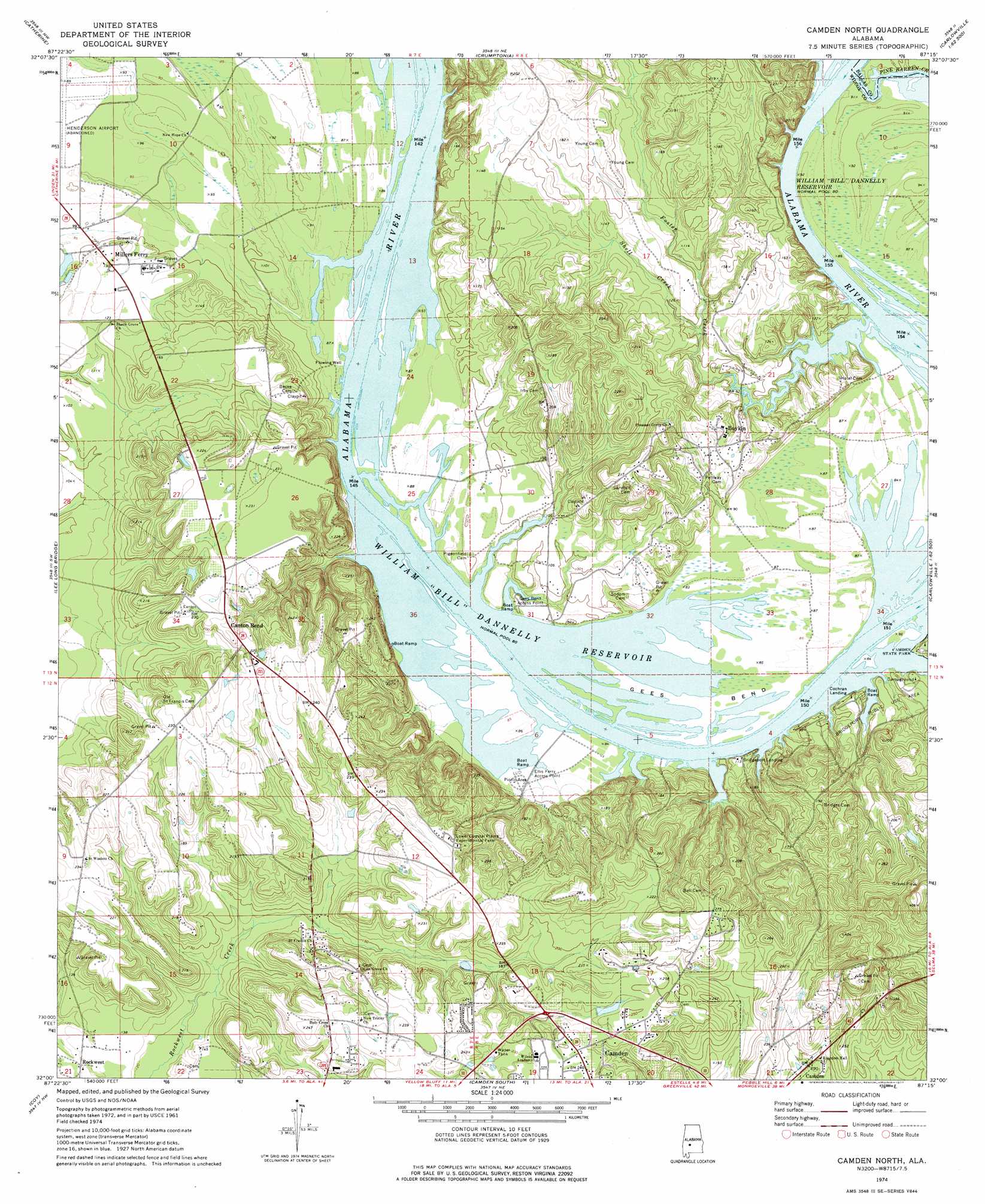
USGS Topo Quad 32087a3 - 1:24,000 scale
| Topo Map Name: | Camden North |
| USGS Topo Quad ID: | 32087a3 |
| Print Size: | ca. 21 1/4" wide x 27" high |
| Southeast Coordinates: | 32° N latitude / 87.25° W longitude |
| Map Center Coordinates: | 32.0625° N latitude / 87.3125° W longitude |
| U.S. State: | AL |
| Filename: | o32087a3.jpg |
| Download Map JPG Image: | Camden North topo map 1:24,000 scale |
| Map Type: | Topographic |
| Topo Series: | 7.5´ |
| Map Scale: | 1:24,000 |
| Source of Map Images: | United States Geological Survey (USGS) |
| Alternate Map Versions: |
Camden North AL 1974, updated 1977 Download PDF Buy paper map Camden North AL 2011 Download PDF Buy paper map Camden North AL 2014 Download PDF Buy paper map |
1:24,000 Topo Quads surrounding Camden North
Thomaston East |
Central Mills |
Safford |
Orrville |
Blackwell Bend |
Flatwood |
Catherine |
Crumptonia |
Tasso |
Elm Bluff |
Kimbrough |
Lee Long Bridge |
Camden North |
Tilden |
Carlowville |
Pine Hill |
Coy |
Camden South |
Rosebud |
Oak Hill |
Lower Peach Tree |
Hybart |
Vredenburgh |
Nadawah |
Mcwilliams |
> Back to 32087a1 at 1:100,000 scale
> Back to 32086a1 at 1:250,000 scale
> Back to U.S. Topo Maps home
Camden North topo map: Gazetteer
Camden North: Bars
Lower Canton Bar (historical) elevation 24m 78′Upper Canton Bar (historical) elevation 24m 78′
Camden North: Beaches
Bridgeport Beach elevation 28m 91′Camden North: Bends
Gees Bend elevation 25m 82′Camden North: Cliffs
Sakti Hata elevation 46m 150′Camden North: Crossings
Ellis Ferry (historical) elevation 24m 78′Camden North: Dams
Ted Loftin Dam elevation 51m 167′Camden North: Islands
Hurricane Island elevation 24m 78′Camden North: Parks
Bridgeport Public Use Area elevation 34m 111′Camden State Park elevation 31m 101′
Camden North: Populated Places
Boykin elevation 39m 127′Millers Ferry elevation 40m 131′
Camden North: Reservoirs
Ted Loftin Lake elevation 51m 167′Camden North: Streams
Foster Creek elevation 24m 78′Pine Barren Creek elevation 24m 78′
Shell Creek elevation 24m 78′
Camden North digital topo map on disk
Buy this Camden North topo map showing relief, roads, GPS coordinates and other geographical features, as a high-resolution digital map file on DVD:
Gulf Coast (LA, MS, AL, FL) & Southwestern Georgia
Buy digital topo maps: Gulf Coast (LA, MS, AL, FL) & Southwestern Georgia
 & Southwestern Georgia map DVD")