Nashville Topo Map Arkansas
To zoom in, hover over the map of Nashville
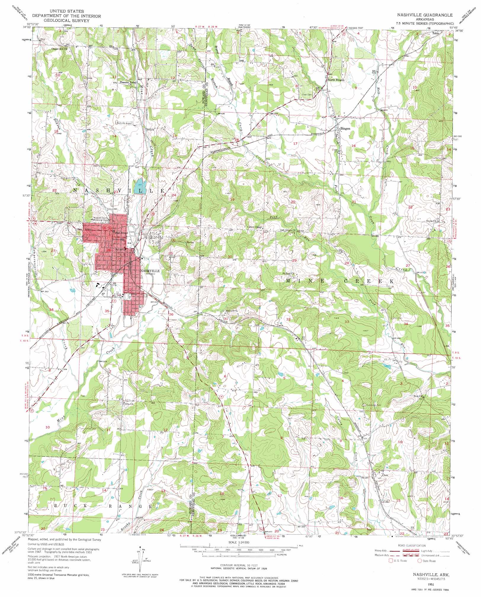
USGS Topo Quad 33093h7 - 1:24,000 scale
| Topo Map Name: | Nashville |
| USGS Topo Quad ID: | 33093h7 |
| Print Size: | ca. 21 1/4" wide x 27" high |
| Southeast Coordinates: | 33.875° N latitude / 93.75° W longitude |
| Map Center Coordinates: | 33.9375° N latitude / 93.8125° W longitude |
| U.S. State: | AR |
| Filename: | o33093h7.jpg |
| Download Map JPG Image: | Nashville topo map 1:24,000 scale |
| Map Type: | Topographic |
| Topo Series: | 7.5´ |
| Map Scale: | 1:24,000 |
| Source of Map Images: | United States Geological Survey (USGS) |
| Alternate Map Versions: |
Nashville AR 1951, updated 1952 Download PDF Buy paper map Nashville AR 1951, updated 1976 Download PDF Buy paper map Nashville AR 2011 Download PDF Buy paper map Nashville AR 2014 Download PDF Buy paper map |
1:24,000 Topo Quads surrounding Nashville
Dierks Dam |
Newhope |
Center Point Ne |
Narrows Dam |
Murfreesboro Ne |
Dierks |
Center Point |
Nathan |
Murfreesboro |
Delight |
Silver Ridge |
Mineral Springs North |
Nashville |
Mccaskill |
Pisgah |
Ben Lomond |
Mineral Springs South |
Columbus |
Washington |
Blevins |
Ashdown East |
Red Bluff |
Mcnab |
Sheppard |
Hope |
> Back to 33093e1 at 1:100,000 scale
> Back to 33092a1 at 1:250,000 scale
> Back to U.S. Topo Maps home
Nashville topo map: Gazetteer
Nashville: Airports
Howard County Airport elevation 166m 544′Nashville: Dams
Lake Nickels Dam elevation 118m 387′North Fork Ozan Creek Watershed Site Five Dam elevation 116m 380′
North Fork Ozan Creek Watershed Site Three Dam elevation 146m 479′
Nashville: Populated Places
Bellair elevation 125m 410′Bingen elevation 126m 413′
Chapel Hill elevation 180m 590′
Clow elevation 125m 410′
Compton (historical) elevation 138m 452′
Doyle elevation 125m 410′
Nashville elevation 118m 387′
North Bingen elevation 136m 446′
Unity elevation 118m 387′
Nashville: Post Offices
Nashville Post Office elevation 118m 387′Nashville: Reservoirs
Lake Nickels elevation 118m 387′North Fork Ozan Creek Watershed Site Reservoir elevation 116m 380′
North Fork Ozan Creek Watershed Site Reservoir elevation 146m 479′
Nashville: Streams
Bryant Branch elevation 134m 439′Cary Creek elevation 117m 383′
Dodson Creek elevation 115m 377′
Holt Creek elevation 112m 367′
Pump Springs Branch elevation 134m 439′
Temperanceville Creek elevation 99m 324′
Nashville digital topo map on disk
Buy this Nashville topo map showing relief, roads, GPS coordinates and other geographical features, as a high-resolution digital map file on DVD: