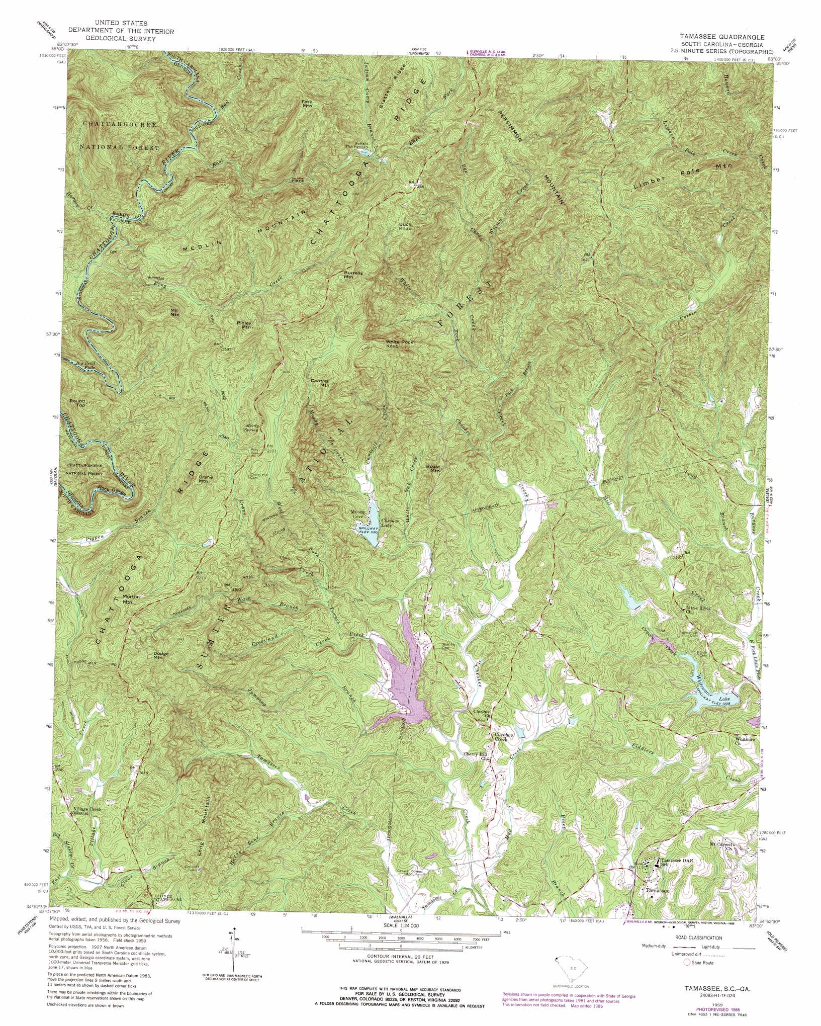
Tamassee Topo Map South Carolina
To zoom in, hover over the map of Tamassee
USGS Topo Quad 34083h1 - 1:24,000 scale
| Topo Map Name: | Tamassee |
| USGS Topo Quad ID: | 34083h1 |
| Print Size: | ca. 21 1/4" wide x 27" high |
| Southeast Coordinates: | 34.875° N latitude / 83° W longitude |
| Map Center Coordinates: | 34.9375° N latitude / 83.0625° W longitude |
| U.S. States: | SC, GA |
| Filename: | o34083h1.jpg |
| Download Map JPG Image: | Tamassee topo map 1:24,000 scale |
| Map Type: | Topographic |
| Topo Series: | 7.5´ |
| Map Scale: | 1:24,000 |
| Source of Map Images: | United States Geological Survey (USGS) |
| Alternate Map Versions: |
Tamassee SC 1959, updated 1960 Download PDF Buy paper map Tamassee SC 1959, updated 1965 Download PDF Buy paper map Tamassee SC 1959, updated 1986 Download PDF Buy paper map Tamassee SC 1996, updated 2000 Download PDF Buy paper map Tamassee SC 2011 Download PDF Buy paper map Tamassee SC 2014 Download PDF Buy paper map |
| FStopo: | US Forest Service topo Tamassee is available: Download FStopo PDF Download FStopo TIF |
1:24,000 Topo Quads surrounding Tamassee
Corbin Knob |
Glenville |
Big Ridge |
Lake Toxaway |
Rosman |
Scaly Mountain |
Highlands |
Cashiers |
Reid |
Eastatoe Gap |
Rabun Bald |
Satolah |
Tamassee |
Salem |
Sunset |
Rainy Mountain |
Whetstone |
Walhalla |
Old Pickens |
Six Mile |
Tugaloo Lake |
Holly Springs |
Westminster |
Seneca |
Clemson |
> Back to 34083e1 at 1:100,000 scale
> Back to 34082a1 at 1:250,000 scale
> Back to U.S. Topo Maps home
Tamassee topo map: Gazetteer
Tamassee: Areas
Lee Falls Special Area elevation 396m 1299′Tamassee: Crossings
Burrells Ford elevation 616m 2020′Tamassee: Dams
Lake Cheohee Dam D-1632 elevation 359m 1177′Rochester Craven Dam D-1633 elevation 330m 1082′
South Carolina Noname 37024 D-1635 Dam elevation 317m 1040′
South Carolina Noname 37026 D-1631 Dam elevation 560m 1837′
Townes Creek Dam D-1634 elevation 331m 1085′
Whitewater Lake Dam D-1636 elevation 307m 1007′
Tamassee: Falls
Big Bend Falls elevation 576m 1889′Hidden Falls elevation 489m 1604′
Kings Creek Falls elevation 663m 2175′
Spoonauger Falls elevation 665m 2181′
Tamassee: Mines
Bee Cove Creek Prospect elevation 756m 2480′John O'Leary Prospect elevation 561m 1840′
Tamassee: Parks
General Pickens Monument elevation 341m 1118′Tamassee: Populated Places
Cheohee elevation 340m 1115′Moody Cove elevation 376m 1233′
Tamassee elevation 324m 1062′
Tamassee: Reservoirs
Lake Cheohee elevation 359m 1177′Lake Cherokee elevation 322m 1056′
Lake Cherokee elevation 331m 1085′
Lake Front Homes Pond elevation 560m 1837′
Lake Isaquenna elevation 326m 1069′
Rochester Lake Number One elevation 330m 1082′
Rochester Lake Number Two elevation 317m 1040′
Sumter National Forest Lake elevation 360m 1181′
Whitewater Lake elevation 307m 1007′
Whitewater Lake elevation 307m 1007′
Tamassee: Ridges
Slatten Ridge elevation 920m 3018′Tamassee: Springs
Moody Spring elevation 721m 2365′Tamassee: Streams
Bad Creek elevation 637m 2089′Bee Creek elevation 416m 1364′
Big Stakey Creek elevation 502m 1646′
Burgess Creek elevation 296m 971′
Cantrell Creek elevation 363m 1190′
Cheohee Creek elevation 304m 997′
Clear Branch elevation 506m 1660′
Crane Creek elevation 351m 1151′
Craven Creek elevation 296m 971′
Crossland Creek elevation 331m 1085′
East Fork Chattooga River elevation 632m 2073′
Harden Creek elevation 616m 2020′
Horse Bone Branch elevation 334m 1095′
Indian Camp Branch elevation 759m 2490′
Jumping Branch elevation 329m 1079′
King Creek elevation 616m 2020′
Knox Creek elevation 318m 1043′
Limber Pole Creek elevation 383m 1256′
Long Branch elevation 304m 997′
Mill Creek elevation 296m 971′
Moody Creek elevation 363m 1190′
Mud Creek elevation 306m 1003′
Pack Branch elevation 391m 1282′
Tamassee Creek elevation 304m 997′
Townes Creek elevation 329m 1079′
Wash Branch elevation 348m 1141′
West Fork Crane Creek elevation 351m 1151′
White Oak Creek elevation 345m 1131′
White Rock Creek elevation 351m 1151′
Wilson Creek elevation 539m 1768′
Tamassee: Summits
Boast Mountain elevation 522m 1712′Buck Knob elevation 867m 2844′
Burrells Mountain elevation 922m 3024′
Cantrell Mountain elevation 810m 2657′
Crane Mountain elevation 773m 2536′
Dodge Mountain elevation 734m 2408′
Fork Mountain elevation 988m 3241′
Limber Pole Mountain elevation 612m 2007′
Long Mountain elevation 626m 2053′
Medlin Mountain elevation 958m 3143′
Mill Mountain elevation 877m 2877′
Morton Mountain elevation 749m 2457′
Persimmon Mountain elevation 948m 3110′
Ridley Mountain elevation 898m 2946′
Round Top elevation 768m 2519′
White Rock Knob elevation 783m 2568′
Tamassee: Trails
Winding Stairs Trail elevation 491m 1610′Tamassee: Valleys
Rock Gorge elevation 524m 1719′Tamassee digital topo map on disk
Buy this Tamassee topo map showing relief, roads, GPS coordinates and other geographical features, as a high-resolution digital map file on DVD:
South Carolina, Western North Carolina & Northeastern Georgia
Buy digital topo maps: South Carolina, Western North Carolina & Northeastern Georgia