Burnsville Topo Map North Carolina
To zoom in, hover over the map of Burnsville
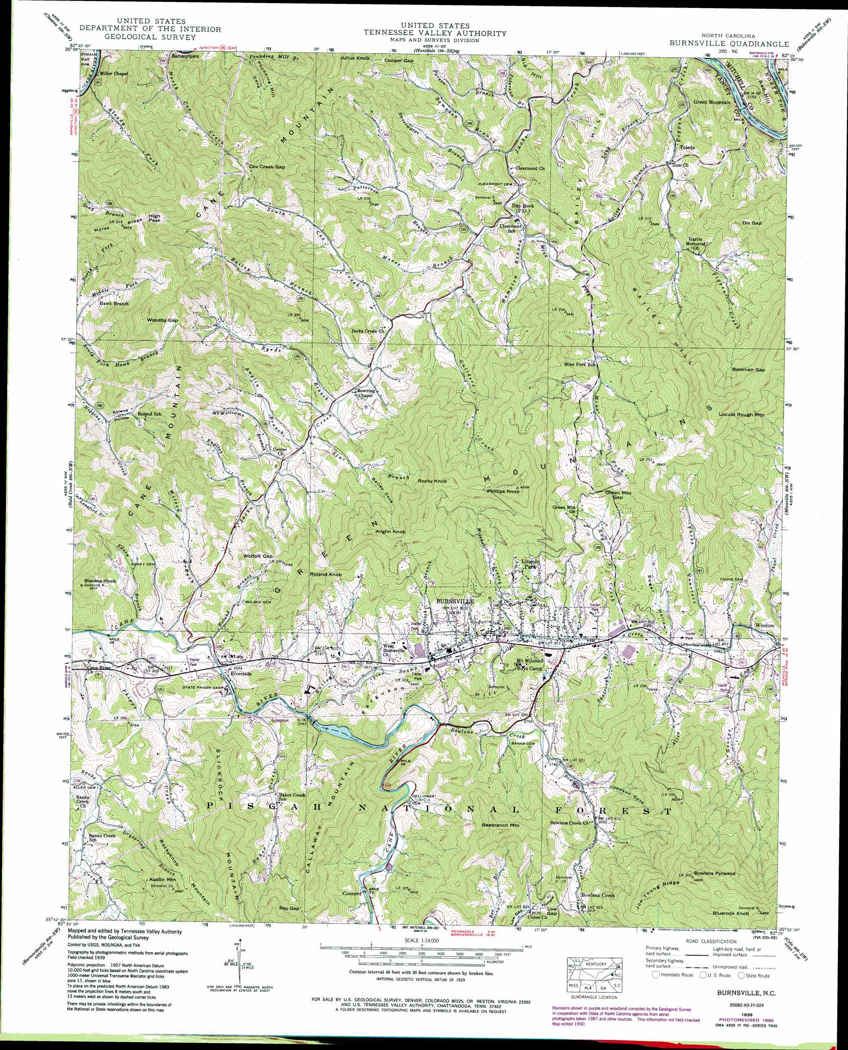
USGS Topo Quad 35082h3 - 1:24,000 scale
| Topo Map Name: | Burnsville |
| USGS Topo Quad ID: | 35082h3 |
| Print Size: | ca. 21 1/4" wide x 27" high |
| Southeast Coordinates: | 35.875° N latitude / 82.25° W longitude |
| Map Center Coordinates: | 35.9375° N latitude / 82.3125° W longitude |
| U.S. State: | NC |
| Filename: | o35082h3.jpg |
| Download Map JPG Image: | Burnsville topo map 1:24,000 scale |
| Map Type: | Topographic |
| Topo Series: | 7.5´ |
| Map Scale: | 1:24,000 |
| Source of Map Images: | United States Geological Survey (USGS) |
| Alternate Map Versions: |
Burnsville NC 1935 Download PDF Buy paper map Burnsville NC 1939, updated 1956 Download PDF Buy paper map Burnsville NC 1939, updated 1971 Download PDF Buy paper map Burnsville NC 1939, updated 1974 Download PDF Buy paper map Burnsville NC 1939, updated 1990 Download PDF Buy paper map Burnsville NC 1939, updated 1990 Download PDF Buy paper map Burnsville NC 1940 Download PDF Buy paper map Burnsville NC 1940 Download PDF Buy paper map Burnsville NC 1998, updated 2001 Download PDF Buy paper map Burnsville NC 2011 Download PDF Buy paper map Burnsville NC 2013 Download PDF Buy paper map Burnsville NC 2016 Download PDF Buy paper map |
| FStopo: | US Forest Service topo Burnsville is available: Download FStopo PDF Download FStopo TIF |
1:24,000 Topo Quads surrounding Burnsville
Telford |
Erwin |
Unicoi |
Iron Mountain Gap |
White Rocks Mountain |
Flag Pond |
Chestoa |
Huntdale |
Bakersville |
Carvers Gap |
Sams Gap |
Bald Creek |
Burnsville |
Micaville |
Spruce Pine |
Mars Hill |
Barnardsville |
Mount Mitchell |
Celo |
Little Switzerland |
Weaverville |
Craggy Pinnacle |
Montreat |
Old Fort |
Marion West |
> Back to 35082e1 at 1:100,000 scale
> Back to 35082a1 at 1:250,000 scale
> Back to U.S. Topo Maps home
Burnsville topo map: Gazetteer
Burnsville: Dams
N W International Dam elevation 773m 2536′Burnsville: Gaps
Bowman Gap elevation 1195m 3920′Cooper Gap elevation 955m 3133′
Cox Creek Gap elevation 962m 3156′
Dix Gap elevation 918m 3011′
Green Mountain Gap elevation 946m 3103′
Low Gap elevation 966m 3169′
Ray Gap elevation 1038m 3405′
Wolfpit Gap elevation 915m 3001′
Woodby Gap elevation 1003m 3290′
Burnsville: Mines
Ray Mine elevation 1012m 3320′Burnsville: Populated Places
Bowlens Creek elevation 924m 3031′Burnsville elevation 861m 2824′
Concord elevation 812m 2664′
Day Book elevation 737m 2417′
Green Mountain elevation 654m 2145′
Hawk Branch elevation 843m 2765′
Lincoln Park elevation 905m 2969′
Mount Mitchell elevation 844m 2769′
Riverside elevation 776m 2545′
Toledo elevation 703m 2306′
Windom elevation 774m 2539′
Burnsville: Post Offices
Day Book Post Office elevation 737m 2417′Mount Mitchell Post Office (historical) elevation 844m 2769′
Burnsville: Ridges
Green Mountain elevation 1224m 4015′Horse Ridge elevation 1162m 3812′
Joe Young Ridge elevation 1342m 4402′
Burnsville: Streams
Allen Branch elevation 784m 2572′Anglin Branch elevation 764m 2506′
Bailey Branch elevation 784m 2572′
Bailey Branch elevation 742m 2434′
Bailey Branch elevation 706m 2316′
Baker Creek elevation 771m 2529′
Bloody Fork elevation 676m 2217′
Bowlens Creek elevation 790m 2591′
Byrds Branch elevation 751m 2463′
Dryspring Branch elevation 819m 2687′
Edney Branch elevation 760m 2493′
English Branch elevation 782m 2565′
George Fork elevation 772m 2532′
Guilders Creek elevation 733m 2404′
Hampton Branch elevation 714m 2342′
Long Branch elevation 659m 2162′
McIntosh Branch elevation 823m 2700′
McWilliams Branch elevation 766m 2513′
Mine Fork elevation 709m 2326′
Mitchell Branch elevation 821m 2693′
Moses Branch elevation 717m 2352′
Parson Branch elevation 729m 2391′
Patterson Branch elevation 715m 2345′
Peterson Branch elevation 704m 2309′
Phipps Creek elevation 758m 2486′
Pine Swamp Branch elevation 774m 2539′
Ray Creek elevation 793m 2601′
Roland Branch elevation 767m 2516′
Sampson Branch elevation 706m 2316′
South Cox Creek elevation 737m 2417′
Star Branch elevation 760m 2493′
Sweetwater Branch elevation 709m 2326′
Sweetwater Branch elevation 718m 2355′
Tantrough Branch elevation 798m 2618′
Three Quarters Creek elevation 784m 2572′
Wilson Branch elevation 764m 2506′
Burnsville: Summits
Anglin Knob elevation 1172m 3845′Austin Mountain elevation 1183m 3881′
Bailey Hill elevation 1244m 4081′
Beebranch Mountain elevation 1175m 3854′
Blevins Knob elevation 979m 3211′
Bluerock Knob elevation 1473m 4832′
Bowlens Pyramid elevation 1496m 4908′
Cane Mountain elevation 1054m 3458′
Ferguson Hill elevation 974m 3195′
High Peak elevation 1290m 4232′
Locust Rough Mountain elevation 1333m 4373′
Phillips Knob elevation 1311m 4301′
Red Hill elevation 734m 2408′
Rocky Knob elevation 1231m 4038′
Rockyknob Mountain elevation 1207m 3959′
Roland Knob elevation 1102m 3615′
Burnsville: Valleys
Bailey Cove elevation 835m 2739′Johnson Cove elevation 846m 2775′
Pounding Mill Cove elevation 711m 2332′
Roland Hollow elevation 770m 2526′
Sugar Hollow elevation 787m 2582′
Burnsville digital topo map on disk
Buy this Burnsville topo map showing relief, roads, GPS coordinates and other geographical features, as a high-resolution digital map file on DVD:
South Carolina, Western North Carolina & Northeastern Georgia
Buy digital topo maps: South Carolina, Western North Carolina & Northeastern Georgia