Wolf Creek Dam Topo Map Kentucky
To zoom in, hover over the map of Wolf Creek Dam
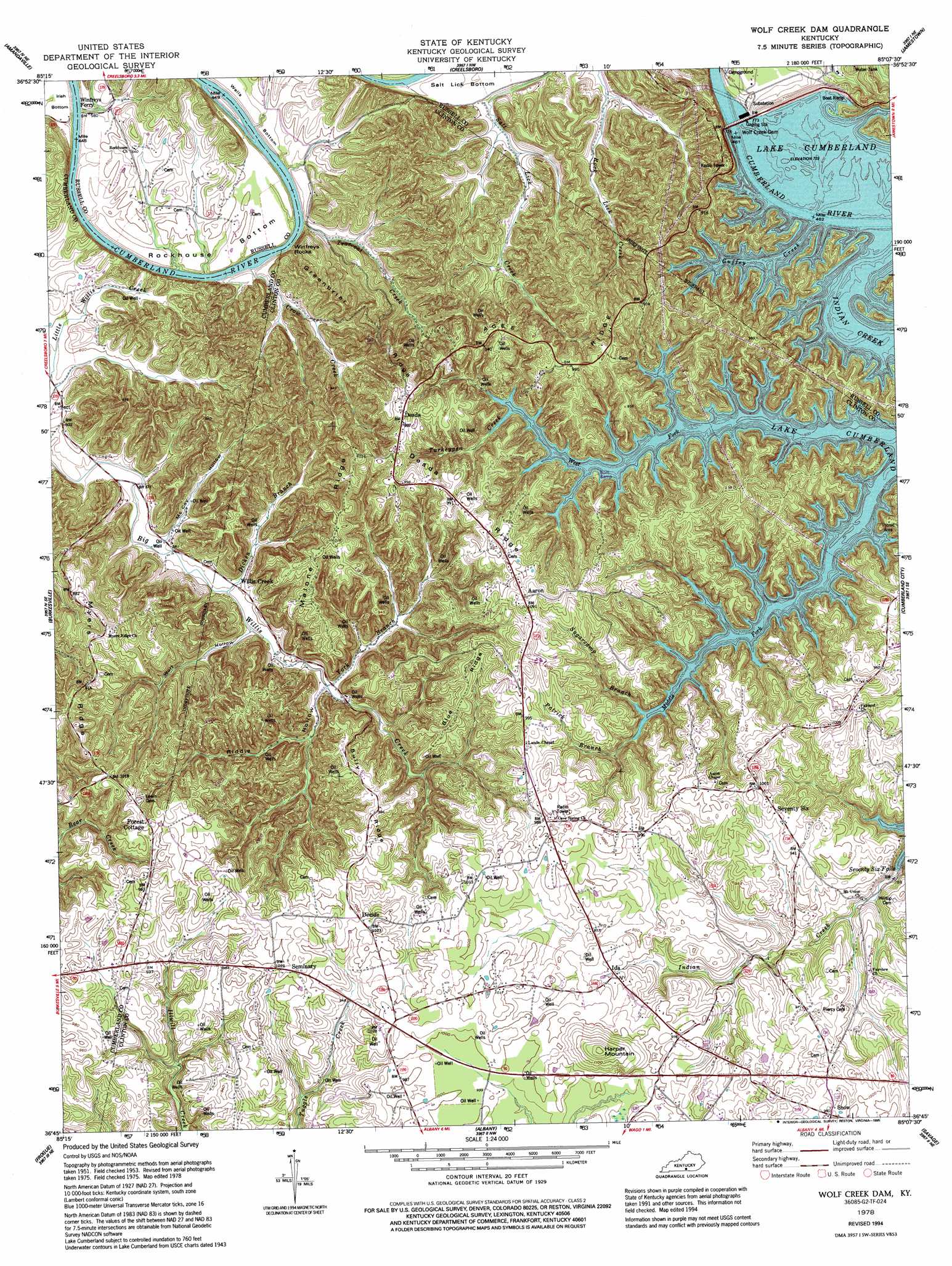
USGS Topo Quad 36085g2 - 1:24,000 scale
| Topo Map Name: | Wolf Creek Dam |
| USGS Topo Quad ID: | 36085g2 |
| Print Size: | ca. 21 1/4" wide x 27" high |
| Southeast Coordinates: | 36.75° N latitude / 85.125° W longitude |
| Map Center Coordinates: | 36.8125° N latitude / 85.1875° W longitude |
| U.S. State: | KY |
| Filename: | o36085g2.jpg |
| Download Map JPG Image: | Wolf Creek Dam topo map 1:24,000 scale |
| Map Type: | Topographic |
| Topo Series: | 7.5´ |
| Map Scale: | 1:24,000 |
| Source of Map Images: | United States Geological Survey (USGS) |
| Alternate Map Versions: |
Wolf Creek Dam KY 1953, updated 1955 Download PDF Buy paper map Wolf Creek Dam KY 1953, updated 1966 Download PDF Buy paper map Wolf Creek Dam KY 1978, updated 1978 Download PDF Buy paper map Wolf Creek Dam KY 1978, updated 1990 Download PDF Buy paper map Wolf Creek Dam KY 1978, updated 1995 Download PDF Buy paper map Wolf Creek Dam KY 2010 Download PDF Buy paper map Wolf Creek Dam KY 2013 Download PDF Buy paper map Wolf Creek Dam KY 2016 Download PDF Buy paper map |
1:24,000 Topo Quads surrounding Wolf Creek Dam
Gradyville |
Columbia |
Montpelier |
Russell Springs |
Eli |
Breeding |
Amandaville |
Creelsboro |
Jamestown |
Jabez |
Waterview |
Burkesville |
Wolf Creek Dam |
Cumberland City |
Parnell |
Blacks Ferry |
Frogue |
Albany |
Savage |
Powersburg |
Dale Hollow Dam |
Dale Hollow Reservoir Se |
Byrdstown |
Moodyville |
Pall Mall |
> Back to 36085e1 at 1:100,000 scale
> Back to 36084a1 at 1:250,000 scale
> Back to U.S. Topo Maps home
Wolf Creek Dam topo map: Gazetteer
Wolf Creek Dam: Bends
Rockhouse Bottom elevation 180m 590′Wolf Creek Dam: Dams
Wolf Creek Dam elevation 220m 721′Wolf Creek Dam: Falls
Seventy Six Falls elevation 227m 744′Wolf Creek Dam: Populated Places
Aaron elevation 322m 1056′Decide elevation 311m 1020′
Desda elevation 301m 987′
Ida elevation 281m 921′
Seventy Six elevation 292m 958′
Snow elevation 299m 980′
Waterview (historical) elevation 229m 751′
Willis Creek elevation 186m 610′
Wolf Creek Dam: Post Offices
Aaron Post Office (historical) elevation 323m 1059′Ariadne Post Office (historical) elevation 294m 964′
Decide Post Office (historical) elevation 263m 862′
Desda Post Office (historical) elevation 302m 990′
Goodson Post Office (historical) elevation 261m 856′
Ida Post Office (historical) elevation 283m 928′
Seminary Post Office (historical) elevation 311m 1020′
Seventy Six Post Office (historical) elevation 300m 984′
Tearcoat Post Office (historical) elevation 182m 597′
Willis Creek Post Office (historical) elevation 182m 597′
Wolf Creek Dam: Reservoirs
Lake Cumberland elevation 220m 721′Wolf Creek Dam: Ridges
Agee Ridge elevation 301m 987′Blue Ridge elevation 294m 964′
Bully Ridge elevation 295m 967′
Desda Ridge elevation 306m 1003′
Greenbrier Ridge elevation 266m 872′
Malone Ridge elevation 312m 1023′
Myers Ridge elevation 297m 974′
Wolf Creek Dam: Streams
Crow Creek elevation 168m 551′Dicken Branch elevation 175m 574′
Guffey Creek elevation 220m 721′
Lester Creek elevation 163m 534′
Patrick Branch elevation 242m 793′
Simpsons Branch elevation 224m 734′
Sugarcamp Branch elevation 229m 751′
Tearcoat Creek elevation 165m 541′
Turkeypen Creek elevation 220m 721′
West Fork elevation 183m 600′
York Branch elevation 187m 613′
Wolf Creek Dam: Summits
Harper Mountain elevation 367m 1204′Winfreys Rocks elevation 253m 830′
Wolf Creek Dam: Valleys
McCoy Hollow elevation 178m 583′Riddle Hollow elevation 187m 613′
Wolf Hollow elevation 185m 606′
Wolf Creek Dam: Wells
Holsapple Gas Well (historical) elevation 291m 954′Warinners Gas Well (historical) elevation 266m 872′
Wolf Creek Dam digital topo map on disk
Buy this Wolf Creek Dam topo map showing relief, roads, GPS coordinates and other geographical features, as a high-resolution digital map file on DVD: