Blackey Topo Map Kentucky
To zoom in, hover over the map of Blackey
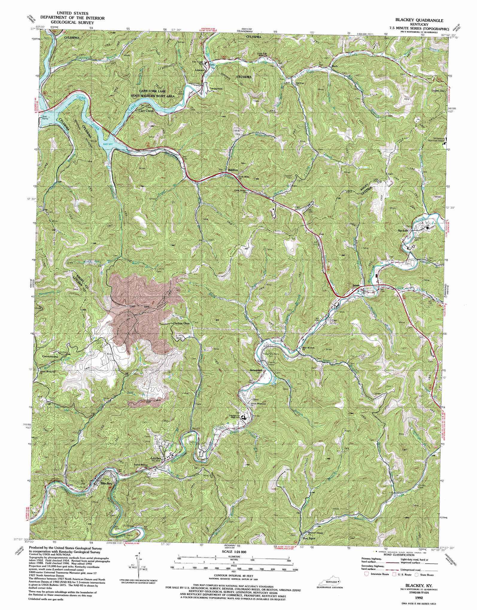
USGS Topo Quad 37082b8 - 1:24,000 scale
| Topo Map Name: | Blackey |
| USGS Topo Quad ID: | 37082b8 |
| Print Size: | ca. 21 1/4" wide x 27" high |
| Southeast Coordinates: | 37.125° N latitude / 82.875° W longitude |
| Map Center Coordinates: | 37.1875° N latitude / 82.9375° W longitude |
| U.S. State: | KY |
| Filename: | o37082b8.jpg |
| Download Map JPG Image: | Blackey topo map 1:24,000 scale |
| Map Type: | Topographic |
| Topo Series: | 7.5´ |
| Map Scale: | 1:24,000 |
| Source of Map Images: | United States Geological Survey (USGS) |
| Alternate Map Versions: |
Blackey KY 1954, updated 1956 Download PDF Buy paper map Blackey KY 1954, updated 1965 Download PDF Buy paper map Blackey KY 1954, updated 1973 Download PDF Buy paper map Blackey KY 1954, updated 1978 Download PDF Buy paper map Blackey KY 1992, updated 1992 Download PDF Buy paper map Blackey KY 2010 Download PDF Buy paper map Blackey KY 2013 Download PDF Buy paper map Blackey KY 2016 Download PDF Buy paper map |
1:24,000 Topo Quads surrounding Blackey
Noble |
Vest |
Handshoe |
Wayland |
Mcdowell |
Hazard North |
Carrie |
Hindman |
Kite |
Wheelwright |
Hazard South |
Vicco |
Blackey |
Mayking |
Jenkins West |
Leatherwood |
Tilford |
Roxana |
Whitesburg |
Flat Gap |
Nolansburg |
Louellen |
Benham |
Appalachia |
Norton |
> Back to 37082a1 at 1:100,000 scale
> Back to 37082a1 at 1:250,000 scale
> Back to U.S. Topo Maps home
Blackey topo map: Gazetteer
Blackey: Gaps
Logan Gap elevation 406m 1332′Blackey: Populated Places
Amelia elevation 390m 1279′Bath elevation 349m 1145′
Blackey elevation 307m 1007′
Breeding Creek (historical) elevation 335m 1099′
Carbon Glow elevation 394m 1292′
Carcassonne elevation 566m 1856′
Carr Creek elevation 338m 1108′
Cody (historical) elevation 308m 1010′
Hot Spot elevation 324m 1062′
Indian Bottom (historical) elevation 318m 1043′
Irishmans elevation 329m 1079′
Isom elevation 339m 1112′
Jeremiah elevation 326m 1069′
Letcher elevation 312m 1023′
Littcarr elevation 332m 1089′
Marshal Branch elevation 439m 1440′
Middle Carr Creek elevation 321m 1053′
Redfox elevation 350m 1148′
Sackett elevation 344m 1128′
Smithsboro (historical) elevation 308m 1010′
Blackey: Post Offices
Addie-Litcar Post Office (historical) elevation 313m 1026′Amburgey Post Office (historical) elevation 335m 1099′
Bath Post Office (historical) elevation 340m 1115′
Beefork Post Office (historical) elevation 354m 1161′
Betze Post Office (historical) elevation 341m 1118′
Blackey Post Office (historical) elevation 304m 997′
Buncombe Post Office (historical) elevation 323m 1059′
Careassone Post Office (historical) elevation 535m 1755′
Cody Post Office (historical) elevation 308m 1010′
Critic Post Office (historical) elevation 323m 1059′
David Post Office (historical) elevation 376m 1233′
Dirk Post Office (historical) elevation 318m 1043′
Does Post Office (historical) elevation 350m 1148′
Grouse Post Office (historical) elevation 527m 1729′
Hemelock Post Office (historical) elevation 326m 1069′
Indian Bottom Post Office (historical) elevation 315m 1033′
Isom Post Office elevation 339m 1112′
Jent Post Office (historical) elevation 341m 1118′
Jeremiah Post Office elevation 328m 1076′
Joseph Post Office (historical) elevation 347m 1138′
Letcher Post Office (historical) elevation 308m 1010′
Red Fox Post Office elevation 422m 1384′
Smiths Post Office (historical) elevation 309m 1013′
Smithsboro post office (historical) elevation 308m 1010′
Smoot Creek Post Office (historical) elevation 351m 1151′
Tana Post Office (historical) elevation 348m 1141′
Theodore Post Office (historical) elevation 422m 1384′
Van Post Office (historical) elevation 442m 1450′
Veen Post Office (historical) elevation 406m 1332′
Witch Post Office (historical) elevation 400m 1312′
Blackey: Streams
Adams Branch elevation 324m 1062′Bee Tree Branch elevation 328m 1076′
Beetree Branch elevation 353m 1158′
Big Doubles Branch elevation 347m 1138′
Black John Branch elevation 354m 1161′
Blair Branch elevation 326m 1069′
Blair Branch elevation 354m 1161′
Breeding Branch elevation 338m 1108′
Breeding Creek elevation 309m 1013′
Caudill Creek elevation 308m 1010′
Crases Branch elevation 308m 1010′
Daniels Branch elevation 351m 1151′
Dead Mare Branch elevation 324m 1062′
Deerlick Branch elevation 313m 1026′
Defeated Creek elevation 313m 1026′
Doty Creek elevation 322m 1056′
Elk Creek elevation 298m 977′
Elkhorn Branch elevation 342m 1122′
Flaxpatch Branch elevation 309m 1013′
Garner Creek elevation 329m 1079′
Hale Branch elevation 334m 1095′
Hollybush Branch elevation 390m 1279′
Irishman Creek elevation 308m 1010′
Johnson Branch elevation 322m 1056′
Lick Branch elevation 368m 1207′
Lick Branch elevation 388m 1272′
Little Carr Fork elevation 315m 1033′
Little Colly Creek elevation 336m 1102′
Little Doubles Branch elevation 341m 1118′
Little Smith Branch elevation 309m 1013′
Low Gap Branch elevation 327m 1072′
Perkins Branch elevation 375m 1230′
Perkins Branch elevation 328m 1076′
Pratts Branch elevation 302m 990′
Right Fork Doty Creek elevation 347m 1138′
Rockhouse Creek elevation 302m 990′
Shingle Branch elevation 312m 1023′
Smith Branch elevation 310m 1017′
Spring Branch elevation 322m 1056′
Stampers Branch elevation 333m 1092′
Sugar Branch elevation 326m 1069′
Trace Fork elevation 346m 1135′
Trace Fork elevation 341m 1118′
Walters Branch elevation 334m 1095′
Walters Branch elevation 333m 1092′
Wolfpen Branch elevation 371m 1217′
Wolfpen Creek elevation 328m 1076′
Blackey: Summits
Apple Rock elevation 406m 1332′Dikson Mountain elevation 493m 1617′
Blackey: Valleys
Back Hollow elevation 336m 1102′Blackey digital topo map on disk
Buy this Blackey topo map showing relief, roads, GPS coordinates and other geographical features, as a high-resolution digital map file on DVD:
Western Virginia & Southern West Virginia
Buy digital topo maps: Western Virginia & Southern West Virginia