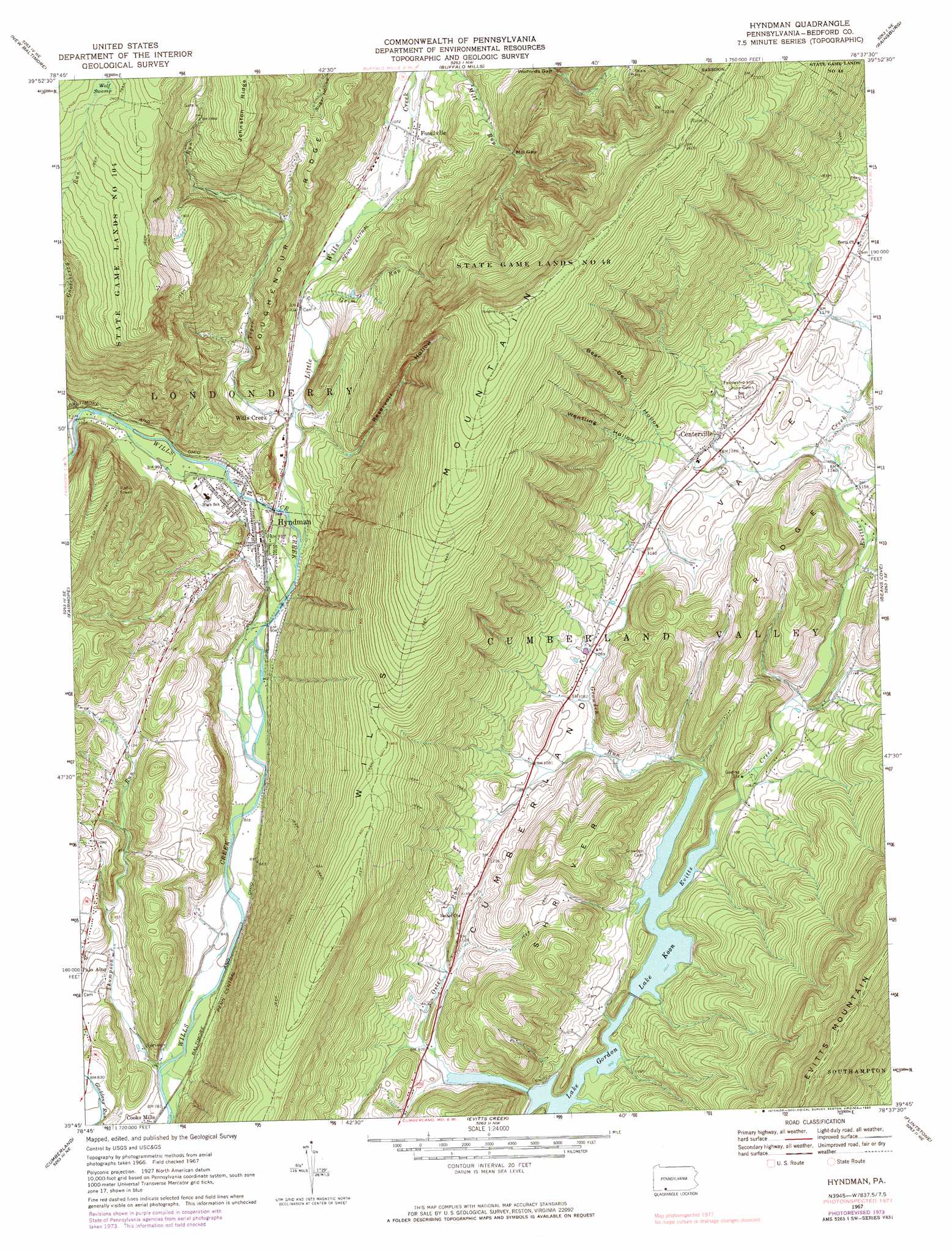
Hyndman Topo Map Pennsylvania
To zoom in, hover over the map of Hyndman
USGS Topo Quad 39078g6 - 1:24,000 scale
| Topo Map Name: | Hyndman |
| USGS Topo Quad ID: | 39078g6 |
| Print Size: | ca. 21 1/4" wide x 27" high |
| Southeast Coordinates: | 39.75° N latitude / 78.625° W longitude |
| Map Center Coordinates: | 39.8125° N latitude / 78.6875° W longitude |
| U.S. State: | PA |
| Filename: | o39078g6.jpg |
| Download Map JPG Image: | Hyndman topo map 1:24,000 scale |
| Map Type: | Topographic |
| Topo Series: | 7.5´ |
| Map Scale: | 1:24,000 |
| Source of Map Images: | United States Geological Survey (USGS) |
| Alternate Map Versions: |
Hyndman PA 1967, updated 1970 Download PDF Buy paper map Hyndman PA 1967, updated 1973 Download PDF Buy paper map Hyndman PA 1967, updated 1983 Download PDF Buy paper map Hyndman PA 2010 Download PDF Buy paper map Hyndman PA 2013 Download PDF Buy paper map Hyndman PA 2016 Download PDF Buy paper map |
1:24,000 Topo Quads surrounding Hyndman
Stoystown |
Central City |
Schellsburg |
Bedford |
Everett West |
Berlin |
New Baltimore |
Buffalo Mills |
Rainsburg |
Clearville |
Wittenberg |
Fairhope |
Hyndman |
Beans Cove |
Chaneysville |
Frostburg |
Cumberland |
Evitts Creek |
Flintstone |
Artemas |
Lonaconing |
Cresaptown |
Patterson Creek |
Oldtown |
Paw Paw |
> Back to 39078e1 at 1:100,000 scale
> Back to 39078a1 at 1:250,000 scale
> Back to U.S. Topo Maps home
Hyndman topo map: Gazetteer
Hyndman: Dams
Thomas W Koon Dam elevation 312m 1023′Hyndman: Gaps
Mill Gap elevation 433m 1420′Wolfords Gap elevation 431m 1414′
Hyndman: Populated Places
Centerville elevation 364m 1194′Fossilville elevation 324m 1062′
Hyndman elevation 286m 938′
Wills Creek elevation 305m 1000′
Hyndman: Post Offices
Bedford Valley Post Office (historical) elevation 364m 1194′Hyndman: Reservoirs
Lake Koon elevation 311m 1020′Hyndman: Ridges
Coughenour Ridge elevation 495m 1624′Wills Mountain elevation 846m 2775′
Hyndman: Streams
Gooseberry Run elevation 322m 1056′Grim Run elevation 298m 977′
Growden Run elevation 310m 1017′
Little Wills Creek elevation 280m 918′
Mill Run elevation 349m 1145′
Oster Run elevation 291m 954′
Thompson Run elevation 237m 777′
Tiger Run elevation 296m 971′
Hyndman: Swamps
Wolf Swamp elevation 723m 2372′Hyndman: Trails
Old Mail Trail elevation 783m 2568′Hyndman: Valleys
Bear Den Hollow elevation 394m 1292′Reservoir Hollow elevation 326m 1069′
Wentling Hollow elevation 394m 1292′
Hyndman digital topo map on disk
Buy this Hyndman topo map showing relief, roads, GPS coordinates and other geographical features, as a high-resolution digital map file on DVD:
 map DVD")