Mecklenburg Topo Map New York
To zoom in, hover over the map of Mecklenburg
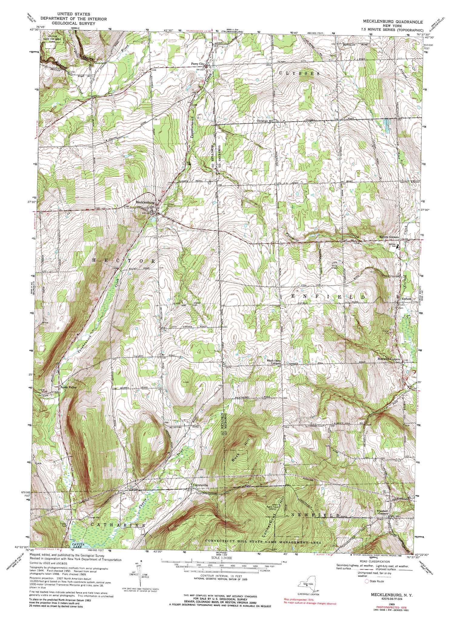
USGS Topo Quad 42076d6 - 1:24,000 scale
| Topo Map Name: | Mecklenburg |
| USGS Topo Quad ID: | 42076d6 |
| Print Size: | ca. 21 1/4" wide x 27" high |
| Southeast Coordinates: | 42.375° N latitude / 76.625° W longitude |
| Map Center Coordinates: | 42.4375° N latitude / 76.6875° W longitude |
| U.S. State: | NY |
| Filename: | o42076d6.jpg |
| Download Map JPG Image: | Mecklenburg topo map 1:24,000 scale |
| Map Type: | Topographic |
| Topo Series: | 7.5´ |
| Map Scale: | 1:24,000 |
| Source of Map Images: | United States Geological Survey (USGS) |
| Alternate Map Versions: |
Mecklenburg NY 1950, updated 1952 Download PDF Buy paper map Mecklenburg NY 1950, updated 1960 Download PDF Buy paper map Mecklenburg NY 1950, updated 1965 Download PDF Buy paper map Mecklenburg NY 1969, updated 1971 Download PDF Buy paper map Mecklenburg NY 1969, updated 1972 Download PDF Buy paper map Mecklenburg NY 1969, updated 1988 Download PDF Buy paper map Mecklenburg NY 2011 Download PDF Buy paper map Mecklenburg NY 2013 Download PDF Buy paper map Mecklenburg NY 2016 Download PDF Buy paper map |
| FStopo: | US Forest Service topo Mecklenburg is available: Download FStopo PDF Download FStopo TIF |
1:24,000 Topo Quads surrounding Mecklenburg
Dresden |
Ovid |
Sheldrake |
Genoa |
Moravia |
Dundee |
Lodi |
Trumansburg |
Ludlowville |
West Groton |
Reading Center |
Burdett |
Mecklenburg |
Ithaca West |
Ithaca East |
Beaver Dams |
Montour Falls |
Alpine |
West Danby |
Willseyville |
Big Flats |
Horseheads |
Erin |
Van Etten |
Spencer |
> Back to 42076a1 at 1:100,000 scale
> Back to 42076a1 at 1:250,000 scale
> Back to U.S. Topo Maps home
Mecklenburg topo map: Gazetteer
Mecklenburg: Airports
Culver Airfield elevation 446m 1463′Willis Airport elevation 420m 1377′
Mecklenburg: Parks
Hector Land Use Area elevation 419m 1374′Mecklenburg: Populated Places
Bostwick Corners elevation 334m 1095′Cayutaville elevation 430m 1410′
Christian Hill elevation 379m 1243′
Enfield elevation 337m 1105′
Mecklenburg elevation 353m 1158′
Perry City elevation 311m 1020′
Sandy Creek Mobile Home Park elevation 349m 1145′
Smith Valley elevation 382m 1253′
Trumbull Corners elevation 415m 1361′
Mecklenburg: Streams
Cayuta Inlet elevation 401m 1315′Fivemile Creek elevation 338m 1108′
Hencoop Creek elevation 308m 1010′
Mecklenburg: Summits
Buck Hill elevation 594m 1948′Connecticut Hill elevation 638m 2093′
Mecklenburg digital topo map on disk
Buy this Mecklenburg topo map showing relief, roads, GPS coordinates and other geographical features, as a high-resolution digital map file on DVD:
New York, Vermont, Connecticut & Western Massachusetts
Buy digital topo maps: New York, Vermont, Connecticut & Western Massachusetts