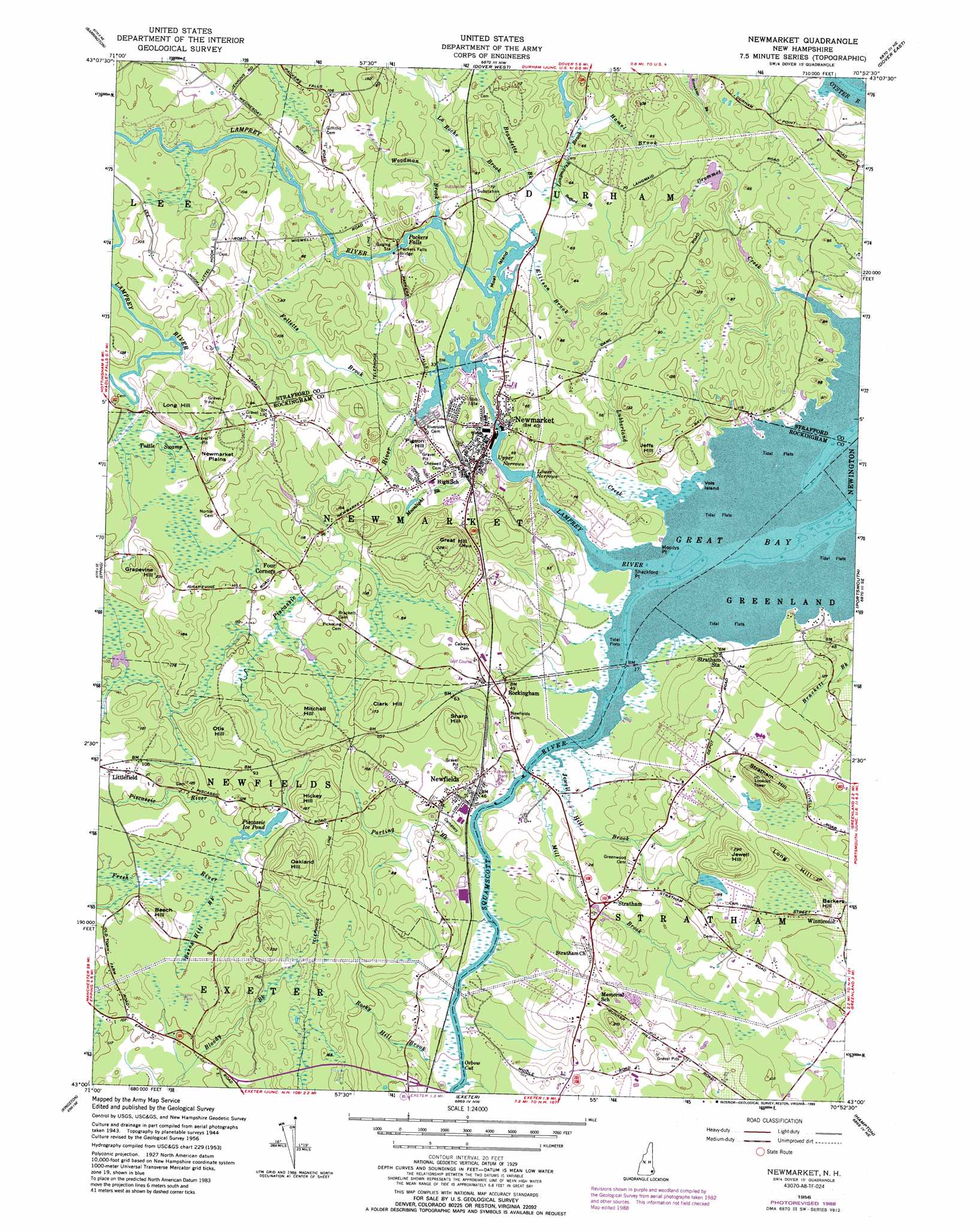
Newmarket Topo Map New Hampshire
To zoom in, hover over the map of Newmarket
USGS Topo Quad 43070a8 - 1:24,000 scale
| Topo Map Name: | Newmarket |
| USGS Topo Quad ID: | 43070a8 |
| Print Size: | ca. 21 1/4" wide x 27" high |
| Southeast Coordinates: | 43° N latitude / 70.875° W longitude |
| Map Center Coordinates: | 43.0625° N latitude / 70.9375° W longitude |
| U.S. State: | NH |
| Filename: | o43070a8.jpg |
| Download Map JPG Image: | Newmarket topo map 1:24,000 scale |
| Map Type: | Topographic |
| Topo Series: | 7.5´ |
| Map Scale: | 1:24,000 |
| Source of Map Images: | United States Geological Survey (USGS) |
| Alternate Map Versions: |
Newmarket NH 1956, updated 1958 Download PDF Buy paper map Newmarket NH 1956, updated 1965 Download PDF Buy paper map Newmarket NH 1956, updated 1977 Download PDF Buy paper map Newmarket NH 1956, updated 1989 Download PDF Buy paper map Newmarket NH 1956, updated 1989 Download PDF Buy paper map Newmarket NH 2012 Download PDF Buy paper map Newmarket NH 2015 Download PDF Buy paper map |
1:24,000 Topo Quads surrounding Newmarket
Parker Mountain |
Baxter Lake |
Rochester |
Somersworth |
North Berwick |
Northwood |
Barrington |
Dover West |
Dover East |
York Harbor |
Mount Pawtuckaway |
Epping |
Newmarket |
Portsmouth |
Kittery |
Sandown |
Kingston |
Hampton |
||
Haverhill |
Newburyport East |
> Back to 43070a1 at 1:100,000 scale
> Back to 43070a1 at 1:250,000 scale
> Back to U.S. Topo Maps home
Newmarket topo map: Gazetteer
Newmarket: Bridges
Packers Falls Bridge elevation 15m 49′Newmarket: Capes
Moodys Point elevation 2m 6′Shackford Point elevation 1m 3′
Newmarket: Channels
Lower Narrows elevation 8m 26′Oxbow Cut elevation 4m 13′
Upper Narrows elevation 6m 19′
Newmarket: Dams
Macallen Dam elevation 10m 32′Packers Falls Dam elevation 12m 39′
Newmarket: Falls
Packers Falls elevation 13m 42′Newmarket: Flats
Newmarket Plains elevation 47m 154′Newmarket: Islands
Moat Island elevation 9m 29′Vols Island elevation 0m 0′
Newmarket: Lakes
Piscassic Ice Pond elevation 30m 98′Newmarket: Parks
Newmarket Industrial and Commercial Historic District elevation 12m 39′Newmarket: Populated Places
Clark Hill elevation 50m 164′Four Corners elevation 30m 98′
Littlefield elevation 38m 124′
Newfields elevation 21m 68′
Newmarket elevation 12m 39′
Rockingham elevation 17m 55′
Stratham elevation 13m 42′
Stratham Station elevation 12m 39′
Winniconic elevation 37m 121′
Newmarket: Post Offices
Newmarket Post Office elevation 13m 42′Newmarket: Reservoirs
Lamprey River Reservoir elevation 10m 32′Lamprey River Reservoir elevation 12m 39′
Newmarket: Streams
Beaudette Brook elevation 12m 39′Bedford Brook elevation 12m 39′
Beech Hill Brook elevation 30m 98′
Crommet Creek elevation 0m 0′
Ellison Brook elevation 9m 29′
Folletts Brook elevation 12m 39′
Fresh River elevation 29m 95′
Jewell Hill Brook elevation 0m 0′
La Roche Brook elevation 11m 36′
Lamprey River elevation 0m 0′
Longmarsh Brook elevation 10m 32′
Lubberland Creek elevation 1m 3′
Mill Brook elevation 5m 16′
Moonlight Brook elevation 5m 16′
Parting Brook elevation 4m 13′
Piscassic River elevation 9m 29′
Rocky Hill Brook elevation 6m 19′
Squamscott River elevation 0m 0′
Woodman Brook elevation 18m 59′
Newmarket: Summits
Barkers Hill elevation 58m 190′Beech Hill elevation 53m 173′
Grapevine Hill elevation 57m 187′
Great Hill elevation 65m 213′
Hickey Hill elevation 52m 170′
Jeffs Hill elevation 38m 124′
Jewell Hill elevation 81m 265′
Long Hill elevation 51m 167′
Long Hill elevation 62m 203′
Mitchell Hill elevation 43m 141′
Oakland Hill elevation 73m 239′
Otis Hill elevation 55m 180′
Pigeon Hill elevation 29m 95′
Sharp Hill elevation 42m 137′
Stratham Hill elevation 88m 288′
Newmarket: Swamps
Tuttle Swamp elevation 24m 78′Newmarket digital topo map on disk
Buy this Newmarket topo map showing relief, roads, GPS coordinates and other geographical features, as a high-resolution digital map file on DVD:
Maine, New Hampshire, Rhode Island & Eastern Massachusetts
Buy digital topo maps: Maine, New Hampshire, Rhode Island & Eastern Massachusetts