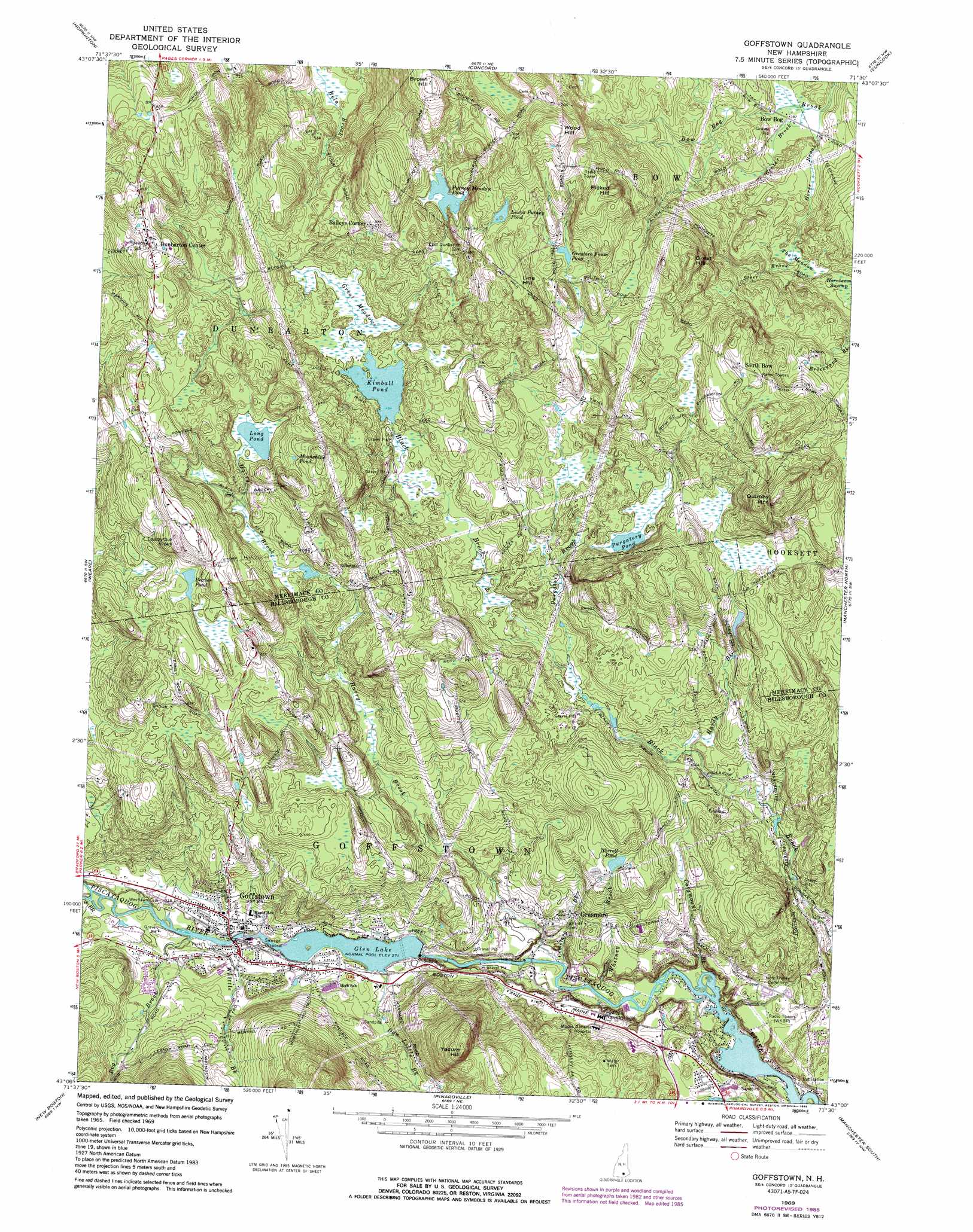
Goffstown Topo Map New Hampshire
To zoom in, hover over the map of Goffstown
USGS Topo Quad 43071a5 - 1:24,000 scale
| Topo Map Name: | Goffstown |
| USGS Topo Quad ID: | 43071a5 |
| Print Size: | ca. 21 1/4" wide x 27" high |
| Southeast Coordinates: | 43° N latitude / 71.5° W longitude |
| Map Center Coordinates: | 43.0625° N latitude / 71.5625° W longitude |
| U.S. State: | NH |
| Filename: | o43071a5.jpg |
| Download Map JPG Image: | Goffstown topo map 1:24,000 scale |
| Map Type: | Topographic |
| Topo Series: | 7.5´ |
| Map Scale: | 1:24,000 |
| Source of Map Images: | United States Geological Survey (USGS) |
| Alternate Map Versions: |
Goffstown NH 1969, updated 1971 Download PDF Buy paper map Goffstown NH 1969, updated 1974 Download PDF Buy paper map Goffstown NH 1969, updated 1985 Download PDF Buy paper map Goffstown NH 1995, updated 1999 Download PDF Buy paper map Goffstown NH 2012 Download PDF Buy paper map Goffstown NH 2015 Download PDF Buy paper map |
1:24,000 Topo Quads surrounding Goffstown
Warner |
Webster |
Penacook |
Loudon |
Pittsfield |
Henniker |
Hopkinton |
Concord |
Suncook |
Gossville |
Deering |
Weare |
Goffstown |
Manchester North |
Candia |
Greenfield |
New Boston |
Pinardville |
Manchester South |
Derry |
Greenville |
Milford |
South Merrimack |
Nashua North |
Windham |
> Back to 43071a1 at 1:100,000 scale
> Back to 43070a1 at 1:250,000 scale
> Back to U.S. Topo Maps home
Goffstown topo map: Gazetteer
Goffstown: Airports
Audley Divide Heliport elevation 216m 708′Country Club Air Park elevation 237m 777′
Sterling Place Heliport elevation 274m 898′
Goffstown: Bridges
Goffstown Covered Railroad Bridge elevation 134m 439′Goffstown: Dams
Greggs Falls Dam elevation 82m 269′Kimball Pond Dam elevation 150m 492′
Putney Meadow Pond Dam elevation 198m 649′
Us Bobbin and Shuttle Company Dam elevation 86m 282′
Goffstown: Falls
Greggs Falls elevation 82m 269′Goffstown: Lakes
Beaver Pond elevation 203m 666′Greylore Farm Pond elevation 210m 688′
Lewis Putney Pond elevation 231m 757′
Long Pond elevation 198m 649′
Moonshine Pond elevation 223m 731′
Purgatory Pond elevation 163m 534′
Tirrell Pond elevation 148m 485′
Goffstown: Parks
Shirley Park elevation 89m 291′Goffstown: Populated Places
Baileys Corner elevation 197m 646′Bow Bog elevation 117m 383′
Dunbarton Center elevation 250m 820′
Goffstown elevation 95m 311′
Grasmere elevation 87m 285′
South Bow elevation 250m 820′
Goffstown: Post Offices
Goffstown Post Office elevation 92m 301′Goffstown: Reservoirs
Glen Lake elevation 82m 269′Kimball Pond elevation 150m 492′
Piscataquog River Reservoir elevation 86m 282′
Putney Meadow Pond elevation 198m 649′
Goffstown: Streams
Bog Brook elevation 87m 285′Catamount Brook elevation 49m 160′
Cemetery Brook elevation 54m 177′
Center Brook elevation 116m 380′
Dan Little Brook elevation 86m 282′
Hardy Brook elevation 106m 347′
Harry Brook elevation 53m 173′
Horse Brook elevation 116m 380′
Purgatory Brook elevation 121m 396′
South Branch Piscataquog River elevation 88m 288′
Whitney Brook elevation 51m 167′
Whittle Brook elevation 87m 285′
Goffstown: Summits
Brown Hill elevation 272m 892′Great Hill elevation 255m 836′
Line Hill elevation 247m 810′
Picked Hill elevation 270m 885′
Quimby Mountain elevation 267m 875′
Wood Hill elevation 270m 885′
Yacum Hill elevation 245m 803′
Goffstown: Swamps
Great Meadows elevation 151m 495′Hornbeam Swamp elevation 136m 446′
The Meadow elevation 133m 436′
Goffstown digital topo map on disk
Buy this Goffstown topo map showing relief, roads, GPS coordinates and other geographical features, as a high-resolution digital map file on DVD:
Maine, New Hampshire, Rhode Island & Eastern Massachusetts
Buy digital topo maps: Maine, New Hampshire, Rhode Island & Eastern Massachusetts